Going back nearly 150 years, cartographers have employed unique technical
solutions to optimize the accuracy of battlefield maps and provide the
necessary support for successful military campaigns.
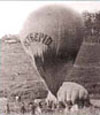
For example, during the American Civil War the Union Army established
a Balloon Corps and launched stationary observation balloons that were
used to accurately map the positions and encampments of Confederate troops
(Civil War Balloon "Intrepid" pictured at right).
With the advent of digital cartography, the accuracy, speed of revisions, and analytical capabilities of mapping products were geometrically increased, helping provide the U.S.Army's Topographic Engineering Center (TEC) with its slogan, "Digitizing the Army in the Quest for Information Dominance."
TEC is a Research and Development laboratory for the U.S.Army Corps of Engineers. Its mission, in part, is to "Provide the warfighter with a superior knowledge of the battlefield." A major, ongoing, project of TEC is the development, fielding, and sustainment of Combat Terrain Information Systems (CTIS). CTIS systems provide military commanders with automated topographic intelligence and support.
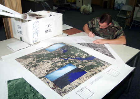
Within the CTIS family of systems is the Digital Topographic Support
System (DTSS), which includes geographic information system (GIS) and image
processing software.
According to Mark Hainsey, Project Director for CTIS, the army began
the development of its DTSS system more than 15 years ago. On the
advice of its prime contractor at that time, CTIS implemented an early
version of ESRI's ArcInfo GIS as a backbone component within the DTSS system.
Today, after several revisions of DTSS, CTIS continues to rely on ESRI's
GIS software for geospatial applications because of its superior analytical
and modeling capabilities. Building the DTSS system around Commercial
Off The Shelf (COTS) software has also greatly reduced operating and training
costs, and subsequently allowed more frequent software updates.
Observes Hainsey, "Years ago, the government typically developed its own software. Now, rather than develop software, we are trying to do a better job of influencing commercial technology. The result is that the products are cheaper, better tested, and updated more frequently."
He continued, "The functional capabilities of DTSS include terrain analysis,
image processing, terrain based data management, and graphics reproduction.
The system is in place with all active-duty engineer terrain teams across
the entire U.S.Army. It is also fielded to reserve units, which
support our active duty army."
These DTSS units are operated by terrain teams to support decision-making
by battlefield commanders. The DTSS system uses, among other data
sources, the National Imagery and Mapping Agency (NIMA) data and products.
NIMA is a United States government agency that provides geospatial databases
and services to other government agencies. The DTSS system uses NIMA's
digital data as a foundation for it's topographic products. Field
observations are collected to create an update overlay for the NIMA maps,
when needed, allowing the DTSS to perform accurate terrain analysis for
front line support.
"There is a wealth of information that soldiers can infer from terrain data," comments Hainsey. "How he can maneuver, where he can set up ambush sites, where he can expect to find possible enemy locations, where he can bed down for the night, the list goes on and on."
To deliver this capacity to the field, a number of configurations are available, including hand carried units, vehicle mounted components, and full systems installed at strategic command locations. DTSS systems have been recently deployed in both Bosnia and Afghanistan and have been very effective.
The DTSS system is typically deployed in a digital Tactical Operation Center as a component of the Army Battle Command System (ABCS), which includes fire support, air defense, maneuver control, combat service support, and terrain analysis. The various components operate digitally and exchange information to support creation of a common operational picture. DTSS provides a map background and terrain input to that common operational picture.
"The common operational picture is what is delivered to the Maneuver Commander," comments Hainsey. "He can look at one single integrated picture of information and see what the disposition of his friendly forces are, what the disposition of his enemy forces, and a map background or a terrain overlay that shows how those systems are going to be operating over the terrain. The commander also has weather input. So all of that information is fused into a single integrated digital picture. This is the direction that the Army is moving, but it is not, as yet, fully implemented. Only a few units within the Army are digital. The majority of the units still operate with what we call our stand-alone stovepipe type systems. Basically, they have to manually fuse their information together to come up with a common relevant picture."
Hainsey believes that in future versions of ABCS, an enterprise GIS
will be implemented so that all databases related to the system are geospatially
enabled.
It is also very likely that GIS will become a primary component of
the Future Combat System (FCS), an evolving project that incorporates elements
from various technologies for tactical military support and response.
Hainsey sees potential military applications in the recently announced
modeling environment for ESRI's ArcGIS, which will allow users to create,
modify, and share spatial models. The models are represented as process
flow diagrams and users will be able to rerun them using different input
data.
"Basically, we run our military operations with rules that are based on certain doctrines," comments Hainsey. "With this new modeling environment, the doctrines can be programmed into the system.
"Now we can build the different components that are required for military operations into a model that someone can run and adjust as needed," he continued. "We are not looking for push-button solutions because it is important to us that our soldiers really understand what they are doing, but at the same time you have to remember that our new soldiers are often coming right out of high school and we need to make the system as simple and user friendly as possible. We train them to use a weapon, how to maintain their vehicles, and now we also want them to learn GIS. It can be overwhelming for them. That is why the new versions of ESRI's software are exciting to us. They combine power and flexibility with easy of use."
About the Author
Jim Baumann writes about international GIS-related topics for ESRI.
He has written articles on various aspects of the computer graphics industry
and information technology for more than 15 years.