Each year for the last five I've put together the top
ten "things" of the past year.Some are events, some are non-events,
some are products, some are people.It's my opportunity to look back
and highlight some topics worthy of attention as we head into the New
Year.These are in no particular order.
Event with the most potential impact on our industry: The creation of the MapServer Foundation.
 While there
was some valid consternation regarding the process by which
it was formed, most members of the MapServer community are cautiously
welcoming Autodesk as a member, and finding their roles in the
organization.I was
criticized for suggesting that "this pairing
[Autodesk and the MapServer community] and the formation of the
Foundation are perhaps the most important events in the geospatial
arena in 20 years." I stand by that statement.The Foundation has the
potential to change GIS forever.Note that I said GIS, not consumer
mapping or search engines, etc.but the technology we know as GIS.
While there
was some valid consternation regarding the process by which
it was formed, most members of the MapServer community are cautiously
welcoming Autodesk as a member, and finding their roles in the
organization.I was
criticized for suggesting that "this pairing
[Autodesk and the MapServer community] and the formation of the
Foundation are perhaps the most important events in the geospatial
arena in 20 years." I stand by that statement.The Foundation has the
potential to change GIS forever.Note that I said GIS, not consumer
mapping or search engines, etc.but the technology we know as GIS.
Natural disasters where our technology and people shone: South East Asia Tsunami and Katrina
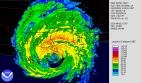 The geospatial community deserves quite a lot of credit for
its work on
site and at home in support of rescue, relief and recovery efforts.GIS
Corps, Mercy Corps and the Katrina Imagery Server team epitomize what's
possible.Newspapers are still recounting tales
of the value of maps in
these efforts.It's also worth noting how "mashups" of technology from
Google and other online services, produced not by us geospatial people,
but concerned programmers, popped up to track those missing and to help
find housing for those who were displaced.I'm hopeful, though not
confident, that we've learned something from these efforts regarding
preparation of data, processes, services, interoperability and staff to
work on future disasters.
The geospatial community deserves quite a lot of credit for
its work on
site and at home in support of rescue, relief and recovery efforts.GIS
Corps, Mercy Corps and the Katrina Imagery Server team epitomize what's
possible.Newspapers are still recounting tales
of the value of maps in
these efforts.It's also worth noting how "mashups" of technology from
Google and other online services, produced not by us geospatial people,
but concerned programmers, popped up to track those missing and to help
find housing for those who were displaced.I'm hopeful, though not
confident, that we've learned something from these efforts regarding
preparation of data, processes, services, interoperability and staff to
work on future disasters.
Second time may not be the charm: GOS II
 After a delayed RFP, ESRI won the Geospatial One-Stop (GOS) II
contract
and gave a demo at its Federal User Conference in February of 2005.The
site went live in July and GOS I was officially off line some months
later.The addition of Google's search appliance, portlets that could
be turned on or off, and enhanced developer access were all welcome
additions.Further, "the Geospatial One-Stop (GOS) Project, an E-gov
initiative under the direction of the USGS, is a finalist in the 2005
President's Quality Award Program."
After a delayed RFP, ESRI won the Geospatial One-Stop (GOS) II
contract
and gave a demo at its Federal User Conference in February of 2005.The
site went live in July and GOS I was officially off line some months
later.The addition of Google's search appliance, portlets that could
be turned on or off, and enhanced developer access were all welcome
additions.Further, "the Geospatial One-Stop (GOS) Project, an E-gov
initiative under the direction of the USGS, is a finalist in the 2005
President's Quality Award Program."
Still, the portal seems a backwater of the geospatial community.Be honest, have you used it for real work? Are hackers developing against it like they are Google and Yahoo tools? Is it time to throw in the towel and try something else? Or get Google or another commercial player to put something together?
Doing the mapping, setting the standard: Google
 Oh, we had MapQuest and MapPoint and some other online
mapping options
but once Google Maps' aura
spread via a soft launch back in February,
everything changed.Everyone wanted the real-time panning and the
simple interface in their mapping products.Then came the satellite
imagery, then the hybrid view, then Google
Earth.Let's face it,
everything that came before and after, from professional GIS to
consumer websites to APIs, is now compared to Google's offerings.
Bottom line: Google obliterated the once difficult task of integrating
remotely sensed with terrain data in a flashy, easily searchable
portal.Leave it to a non-GIS company to make geography sexy.
Oh, we had MapQuest and MapPoint and some other online
mapping options
but once Google Maps' aura
spread via a soft launch back in February,
everything changed.Everyone wanted the real-time panning and the
simple interface in their mapping products.Then came the satellite
imagery, then the hybrid view, then Google
Earth.Let's face it,
everything that came before and after, from professional GIS to
consumer websites to APIs, is now compared to Google's offerings.
Bottom line: Google obliterated the once difficult task of integrating
remotely sensed with terrain data in a flashy, easily searchable
portal.Leave it to a non-GIS company to make geography sexy.
USGS reorg/search for new mapping center
 I don't expect too many people know or care about the
internal
reorganization of the United State Geological Survey (USGS).But,
people do know that the National Geospatial Technical Operations Center
(NGTOC) was to be created in
Denver, which beat out Rolla, Missouri and
Reston, Virginia for the title back in September.Now investigations
are underway to explore how that decision was made and if it will
stick.Equally important, the government has begun an A-76 process
where it compares the cost of government employees doing USGS work with
that of the private sector doing the same work.If the private sector
"wins," even more federal jobs will be lost than those expected from
the consolidation to Denver (or wherever).USGS didn't come out looking
so good in this process.Acting director Patrick Leahy had just stepped
in the door as the decision was made by Karen Siderelis.I for one hope
USGS can gain back its credibility.
I don't expect too many people know or care about the
internal
reorganization of the United State Geological Survey (USGS).But,
people do know that the National Geospatial Technical Operations Center
(NGTOC) was to be created in
Denver, which beat out Rolla, Missouri and
Reston, Virginia for the title back in September.Now investigations
are underway to explore how that decision was made and if it will
stick.Equally important, the government has begun an A-76 process
where it compares the cost of government employees doing USGS work with
that of the private sector doing the same work.If the private sector
"wins," even more federal jobs will be lost than those expected from
the consolidation to Denver (or wherever).USGS didn't come out looking
so good in this process.Acting director Patrick Leahy had just stepped
in the door as the decision was made by Karen Siderelis.I for one hope
USGS can gain back its credibility.
Acquisitions and spinoffs: a trend in data
This year no single acquisition/merger stood out as earth shattering. To review: We had ORBIMAGE acquire one part of Space Imaging and Sanborn the other.Hexagon, after a protracted and hostile takeover bid, finally got Leica Geosystems.Oracle grabbed Siebel, which is important to the location intelligence arena.GlobeXplorer ate up AirphotoUSA, after Intermap decided not to pursue its intent to purchase the company.Layton GeoScience spun out of Layton Graphics, will focus on its PDF for geo products.Yahoo acquired Whereonearth to pump up its local search offering.And, in another aerial imagery deal, EarthData acquired a part of Emerge that had been with LJT & Associates.
 The trend is for those who need the data to begin acquiring
the
companies who make it.And, if they cannot do the acquiring, they enter
into long term contracts for the data.Consider Microsoft's deals with
ORBIMAGE, Pictometry, EarthData and Harris to power Virtual Earth/Live
Local, and Google's deals with DigitalGlobe and others.After perhaps
too many years thinking about the technology in terms of using geodata,
these new players are getting back to basics: data as the backend
engine or the fuel to power the apps.That may well be what pushes the
new players over the top in competing with traditional GIS companies.I
grant a special commendation to GlobeXplorer
for its emphasis on
serving imagery to the professional community directly in a preferred
environment (AutoCAD, ArcGIS, WMS, etc.).
The trend is for those who need the data to begin acquiring
the
companies who make it.And, if they cannot do the acquiring, they enter
into long term contracts for the data.Consider Microsoft's deals with
ORBIMAGE, Pictometry, EarthData and Harris to power Virtual Earth/Live
Local, and Google's deals with DigitalGlobe and others.After perhaps
too many years thinking about the technology in terms of using geodata,
these new players are getting back to basics: data as the backend
engine or the fuel to power the apps.That may well be what pushes the
new players over the top in competing with traditional GIS companies.I
grant a special commendation to GlobeXplorer
for its emphasis on
serving imagery to the professional community directly in a preferred
environment (AutoCAD, ArcGIS, WMS, etc.).
Can an individual make a difference? Intergraph reorganization
 Yes, every other year one of the big private companies
reorganizes and
I have to learn the new names of the divisions.This year it was
Intergraph's turn and I had to
learn to say SG&I for Security,
Government & Infrastructure and PP&M for Process, Power &
Marine.However, give credit where credit is due.Halsey Wise has made
the right moves to please stockholders, accelerating the stock price
from around $27 per share to near $50.In addition, he's hired one of
the most respected geospatial visionaries in Peter Batty, now on board
as CTO.Will he be able to lead technically and coerce the changes in
marketing that can bring the company out of its own user base to new
customers? I think he's got a good shot at it.
Yes, every other year one of the big private companies
reorganizes and
I have to learn the new names of the divisions.This year it was
Intergraph's turn and I had to
learn to say SG&I for Security,
Government & Infrastructure and PP&M for Process, Power &
Marine.However, give credit where credit is due.Halsey Wise has made
the right moves to please stockholders, accelerating the stock price
from around $27 per share to near $50.In addition, he's hired one of
the most respected geospatial visionaries in Peter Batty, now on board
as CTO.Will he be able to lead technically and coerce the changes in
marketing that can bring the company out of its own user base to new
customers? I think he's got a good shot at it.
Product buzz for 2006: ArcGIS Explorer
 What's the buzz for 2006 that started in 2005? ArcGIS
Explorer.The
rather clunky name refers to what has been called ESRI's "Google Earth
killer" among other things.While it has some similarity with that free
download, it also connects to ESRI powered 3D data via ArcGIS Server,
ArcIMS, ArcWeb Services as well as OGC WMS servers.ESRI has been
taking a page from Google's playbook and doing a "soft launch," talking
about the product and showing it only sparingly.The public beta is
expected in the first quarter of next year.
What's the buzz for 2006 that started in 2005? ArcGIS
Explorer.The
rather clunky name refers to what has been called ESRI's "Google Earth
killer" among other things.While it has some similarity with that free
download, it also connects to ESRI powered 3D data via ArcGIS Server,
ArcIMS, ArcWeb Services as well as OGC WMS servers.ESRI has been
taking a page from Google's playbook and doing a "soft launch," talking
about the product and showing it only sparingly.The public beta is
expected in the first quarter of next year.
New place for maps: the media frenzy
 The popular media (that is, non-academic or industry
publications)
began to cover mapping technology with far more vigor than any previous
year.The big flashy apps from Google, Yahoo and Microsoft certainly
helped.So too did the variety of mashups from the old standards
Craigslist and ChicagoCrime to new ones highlighting the New York
Marathon or where Xbox 360s are available.
The popular media (that is, non-academic or industry
publications)
began to cover mapping technology with far more vigor than any previous
year.The big flashy apps from Google, Yahoo and Microsoft certainly
helped.So too did the variety of mashups from the old standards
Craigslist and ChicagoCrime to new ones highlighting the New York
Marathon or where Xbox 360s are available.
Not only did the media outlets report on the technology, the open APIs and the websites, but they invested in it.The Washington Post hired Adrian Holovaty, the fellow behind Chicagocrime.org, to be its "editor, editorial innovations." See some mashups from its RSS feeds here.The Toronto Star and others, are using the technology to enhance their websites.That paper offers a traffic camera mashup, one related to report on homicides and another related to a missing persons case.ESRI tried to get the press excited about maps with MapStudio, but these new offerings clearly jumped to the head of the line.
MIA: MapQuest
 Whither MapQuest? In an interview
earlier this year the company told us
there were many new things to come, but of course we've not yet seen
them.As Microsoft, Google, Yahoo and even A9 struggle to keep their
names in our heads as players in the new geography and AOL ponders its
future, MapQuest seems to stand still.That said, it continues to
command the largest
share of those who visit mapping sites.I confess
to being a huge MapQuest fan in the early days (perhaps due to its
roots not far from Penn State) but have been lured away by Google
Local.And, frankly, it will be hard to win me back!
Whither MapQuest? In an interview
earlier this year the company told us
there were many new things to come, but of course we've not yet seen
them.As Microsoft, Google, Yahoo and even A9 struggle to keep their
names in our heads as players in the new geography and AOL ponders its
future, MapQuest seems to stand still.That said, it continues to
command the largest
share of those who visit mapping sites.I confess
to being a huge MapQuest fan in the early days (perhaps due to its
roots not far from Penn State) but have been lured away by Google
Local.And, frankly, it will be hard to win me back!
Event with the most potential impact on our industry: The creation of the MapServer Foundation.
While there
was some valid consternation regarding the process by which
it was formed, most members of the MapServer community are cautiously
welcoming Autodesk as a member, and finding their roles in the
organization.I was
criticized for suggesting that "this pairing
[Autodesk and the MapServer community] and the formation of the
Foundation are perhaps the most important events in the geospatial
arena in 20 years." I stand by that statement.The Foundation has the
potential to change GIS forever.Note that I said GIS, not consumer
mapping or search engines, etc.but the technology we know as GIS.Natural disasters where our technology and people shone: South East Asia Tsunami and Katrina
The geospatial community deserves quite a lot of credit for
its work on
site and at home in support of rescue, relief and recovery efforts.GIS
Corps, Mercy Corps and the Katrina Imagery Server team epitomize what's
possible.Newspapers are still recounting tales
of the value of maps in
these efforts.It's also worth noting how "mashups" of technology from
Google and other online services, produced not by us geospatial people,
but concerned programmers, popped up to track those missing and to help
find housing for those who were displaced.I'm hopeful, though not
confident, that we've learned something from these efforts regarding
preparation of data, processes, services, interoperability and staff to
work on future disasters.Second time may not be the charm: GOS II
Still, the portal seems a backwater of the geospatial community.Be honest, have you used it for real work? Are hackers developing against it like they are Google and Yahoo tools? Is it time to throw in the towel and try something else? Or get Google or another commercial player to put something together?
Doing the mapping, setting the standard: Google
Oh, we had MapQuest and MapPoint and some other online
mapping options
but once Google Maps' aura
spread via a soft launch back in February,
everything changed.Everyone wanted the real-time panning and the
simple interface in their mapping products.Then came the satellite
imagery, then the hybrid view, then Google
Earth.Let's face it,
everything that came before and after, from professional GIS to
consumer websites to APIs, is now compared to Google's offerings.
Bottom line: Google obliterated the once difficult task of integrating
remotely sensed with terrain data in a flashy, easily searchable
portal.Leave it to a non-GIS company to make geography sexy.USGS reorg/search for new mapping center
I don't expect too many people know or care about the
internal
reorganization of the United State Geological Survey (USGS).But,
people do know that the National Geospatial Technical Operations Center
(NGTOC) was to be created in
Denver, which beat out Rolla, Missouri and
Reston, Virginia for the title back in September.Now investigations
are underway to explore how that decision was made and if it will
stick.Equally important, the government has begun an A-76 process
where it compares the cost of government employees doing USGS work with
that of the private sector doing the same work.If the private sector
"wins," even more federal jobs will be lost than those expected from
the consolidation to Denver (or wherever).USGS didn't come out looking
so good in this process.Acting director Patrick Leahy had just stepped
in the door as the decision was made by Karen Siderelis.I for one hope
USGS can gain back its credibility.Acquisitions and spinoffs: a trend in data
This year no single acquisition/merger stood out as earth shattering. To review: We had ORBIMAGE acquire one part of Space Imaging and Sanborn the other.Hexagon, after a protracted and hostile takeover bid, finally got Leica Geosystems.Oracle grabbed Siebel, which is important to the location intelligence arena.GlobeXplorer ate up AirphotoUSA, after Intermap decided not to pursue its intent to purchase the company.Layton GeoScience spun out of Layton Graphics, will focus on its PDF for geo products.Yahoo acquired Whereonearth to pump up its local search offering.And, in another aerial imagery deal, EarthData acquired a part of Emerge that had been with LJT & Associates.
The trend is for those who need the data to begin acquiring
the
companies who make it.And, if they cannot do the acquiring, they enter
into long term contracts for the data.Consider Microsoft's deals with
ORBIMAGE, Pictometry, EarthData and Harris to power Virtual Earth/Live
Local, and Google's deals with DigitalGlobe and others.After perhaps
too many years thinking about the technology in terms of using geodata,
these new players are getting back to basics: data as the backend
engine or the fuel to power the apps.That may well be what pushes the
new players over the top in competing with traditional GIS companies.I
grant a special commendation to GlobeXplorer
for its emphasis on
serving imagery to the professional community directly in a preferred
environment (AutoCAD, ArcGIS, WMS, etc.).Can an individual make a difference? Intergraph reorganization
Yes, every other year one of the big private companies
reorganizes and
I have to learn the new names of the divisions.This year it was
Intergraph's turn and I had to
learn to say SG&I for Security,
Government & Infrastructure and PP&M for Process, Power &
Marine.However, give credit where credit is due.Halsey Wise has made
the right moves to please stockholders, accelerating the stock price
from around $27 per share to near $50.In addition, he's hired one of
the most respected geospatial visionaries in Peter Batty, now on board
as CTO.Will he be able to lead technically and coerce the changes in
marketing that can bring the company out of its own user base to new
customers? I think he's got a good shot at it.Product buzz for 2006: ArcGIS Explorer
What's the buzz for 2006 that started in 2005? ArcGIS
Explorer.The
rather clunky name refers to what has been called ESRI's "Google Earth
killer" among other things.While it has some similarity with that free
download, it also connects to ESRI powered 3D data via ArcGIS Server,
ArcIMS, ArcWeb Services as well as OGC WMS servers.ESRI has been
taking a page from Google's playbook and doing a "soft launch," talking
about the product and showing it only sparingly.The public beta is
expected in the first quarter of next year.New place for maps: the media frenzy
The popular media (that is, non-academic or industry
publications)
began to cover mapping technology with far more vigor than any previous
year.The big flashy apps from Google, Yahoo and Microsoft certainly
helped.So too did the variety of mashups from the old standards
Craigslist and ChicagoCrime to new ones highlighting the New York
Marathon or where Xbox 360s are available.Not only did the media outlets report on the technology, the open APIs and the websites, but they invested in it.The Washington Post hired Adrian Holovaty, the fellow behind Chicagocrime.org, to be its "editor, editorial innovations." See some mashups from its RSS feeds here.The Toronto Star and others, are using the technology to enhance their websites.That paper offers a traffic camera mashup, one related to report on homicides and another related to a missing persons case.ESRI tried to get the press excited about maps with MapStudio, but these new offerings clearly jumped to the head of the line.
MIA: MapQuest
From Our Homepage
Saying Farewell to an Amazing Journey
Communicating with Maps
Is There a GIS Career Ladder?
What does it mean to be geospatially smart? Series
Ways Real Estate and Property Developers Utilize Melissa GeoData for Data-Driven Decisions
Unlocking Value From Daily Satellite Imagery and Insights
Maximizing the Value of Your Address Data with Geo Addressing
How Indoor Mapping Enhances the Security of Smart Buildings
Look Ahead: AI, Location Intelligence and Efficiency
Collaboration Takes on Sea Level Rise & Dynamic Technology Environments
Brownies for Brownfields
Has Everything Been Mapped Already?
How Is Data Literacy Changing in an Artificial Intelligence Landscape
Portfolios for GIS Professionals: More Than Just Maps
How to Create a Distance Matrix in QGIS - A Step-by-Step Guide
7 Ideas for Bringing GIS into the K-12 Classroom
The Geography of Movement