On October 15th of this year, a 6.7 magnitude
earthquake struck the Big Island of Hawaii about six miles north of the
Keahole-Kona Airport at 7:07 a.m. on a Sunday morning. Eight
minutes later, a second earthquake of magnitude 6.0 (the United States
Geologic Survey [USGS] has confirmed that it was an entirely separate
quake based on its location and depth) jolted the same area, its
epicenter located approximately 27 miles north of the first quake. Both
were considered "strong" earthquakes but no fatalities resulted from
either episode. Power outages affected the Big Island, Maui and Oahu. I
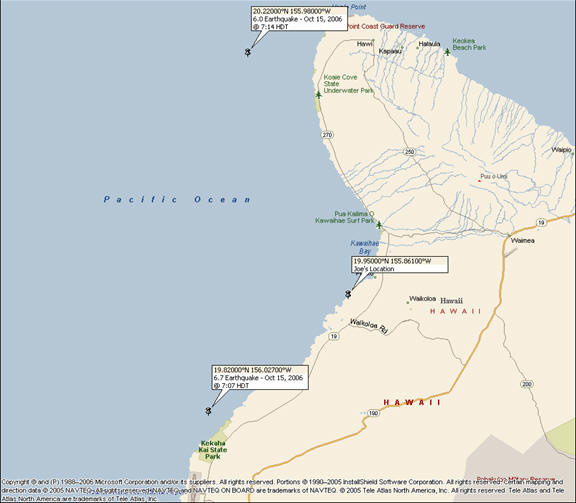
happened to be on the Big Island at the time, approximately 15 miles
from the epicenter of both quakes (refer to the map below), and I found
myself "in the dark" about what was going on and how much danger
I was in. Were these quakes on or offshore? How big were these quakes
and were they big enough to generate a tsunami? And if a tsunami was
possible, what evacuation routes should be taken? In short, I wanted to
know what was going on. I wanted to know what the local authorities
knew and where to turn for more information. Specifically, I wanted to
know if I was still in harm's way.
It's a reasonable request, given that we've spent billions of dollars in the U.S. preparing for the next major terrorist attack, hurricane and any other human or natural disaster. If what I encountered is any indication, we are woefully unprepared to assist those affected for the next one. Based on my experience and my subsequent research for this report, the information I wanted was very much dependent on the availability of the right geospatial data. Actually, the information was readily available, but it had no way of reaching me.
This report is not meant to be an indictment of any federal, state or local agency, but a first-hand account of what I observed, what I learned subsequently, and what I know is possible to mitigate what I believe to be a problem. As many of you will understand, the technological feasibility of solving a problem is often well ahead of other more difficult challenges. Despite the investments we have supposedly made in disaster planning and response, I came away with no clear understanding of who was in charge of informing the public and how it would be done.
Let me begin with one specific observation: These quakes occurred very early on a Sunday morning on an island in the Pacific that has a low population density, not in a major metropolitan area in the middle of rush hour. Consider the consequences of this occurring in San Francisco. Consider also if the more recent, powerful 8.3 magnitude earthquake off the Kuril Islands had affected Hawaii or the west cost of the U.S. Not that these kinds of events haven't happened before, such as in the Bay Area (the 1989 Loma Prieta quake that measured 6.9), but rather consider how government agencies have supposedly been preparing to mitigate communication problems during a disaster since 9/11 and more recently with hurricane Katrina. It appears that still more needs to be done to communicate with those who are actually experiencing the disaster as it occurs or others who may be affected by its aftermath.
Background Information
I was on the Big Island of Hawaii for a vacation when the earthquakes hit. When the first quake struck, I was outside in a garden area of my hotel. I felt the initial shock wave that cascaded over the hotel roof with a sound that was unlike anything I had ever heard and was coming from all directions. Then the ground began to shake, which lasted for about 20 seconds. It was a strong "shake" but I did not completely lose my balance. When ground motion stopped, my immediate thoughts turned to finding my wife. I ran back inside the building, but the power in our hotel was out and stairwells were completely dark. My wife had been in a glass-enclosed shower at the time where she was shaken violently and did need to hold on to a bar to remain stable. The quake tossed lamps and other items to the floor, knocked pictures off the wall and cracked the dry wall in the room in several places. Fortunately, my wife and I found each other 20 minutes later outside in a parking area. At that point she said she had overheard someone talking about a tsunami and that the best thing would be to get in our car and get to higher ground. So, we sped from the hotel parking lot, passing other hotel guests who were milling around, obviously uninformed and awaiting further instruction . . . presuming someone HAD information and further instructions! As we pulled away from the hotel, we turned on the radio to find out what was going on, only to hear . . . music. Now here is where the story begins.
Information Flow Expectations
What I expected to hear was the Emergency Broadcast System. You know, "In the event of a real emergency you would be instructed to tune to "XXXX" station." Well a strong earthquake felt like a real emergency to me and we never heard that broadcast, which is now known as the Emergency Alert System (EAS). However, according to the Federal Communications Commission (FCC), "The EAS is designed to provide the President with a means to address the American people in the event of a national emergency." Okay, this was not a national emergency, but indeed it was a "local" emergency. So, who is supposed to communicate the information? What agency is charged with informing the public about a local emergency?
Driving north along the Queen Kaahumanu Highway from our hotel, we encountered several road cuts where fallen rocks and some car-sized boulders had been strewn across the road. [The photos below were taken less than 1:45 hours after the quake.] Some authority needed to know about the blockages we encountered and the danger they presented to drivers, but who do you call? 911? Eventually, one radio station, broadcasting from Honolulu and obviously not affected by the power outage (or whose backup generators were operating when others were not), did break in with news about the quakes. Mostly we learned about power outages on Oahu and the Big Island, but that was it. Then, about one hour after our departure from the hotel and while awaiting news in Waimea (see map above; 20 miles from our hotel and at an elevation of 2500 feet above sea level), we heard from that same radio station that no tsunami threat existed. I don't remember who the station said was the source of this alert but my recollection is that the disc jockey simply said "government sources." That was it. No official broadcast, no government authority verifying the statement. We still felt in the dark. If it wasn't for this single radio station, which truly did not have any authority to relay an "official" announcement, we would have been left wondering about the status of our situation. After some time, we decided to trust the Oahu disc jockey and return to the hotel to see what was going on.
I expected more, and as tax payers we deserve more. Was there going to be a tsunami and if so, when would it occur? If an evacuation was necessary, where should we go? What roads were open and what was the travel time to a safe haven? The reports from the Oahu radio station provided us with only the basics: The earthquake registered 6.6 (later upgraded to 6.7), and ï¿1⁄2 eventually -no tsunami threat existed. And this info only gradually trickled in to the radio station over time; the station told us what they "heard" from local citizens calling into the station but there was no "official" report. So, I began to investigate the flow of information that I had expected to receive.
Where Does the Information Flow Start?
Seismic recording stations at the USGS's Hawaiian Volcanic Observatory (HVO) on the Big Island captured the earthquake from its many recording stations on the island. I spoke with Jim Kauahikaua of HVO who said that the observatory's mission is to provide initial position and magnitude information when earthquakes occur. They usually have a position of the earthquake within five minutes of the event and will send this information to local civil defense authorities. But HVO and the USGS are not responsible for alerting the public, and merely communicate the geospatial information to other agencies.
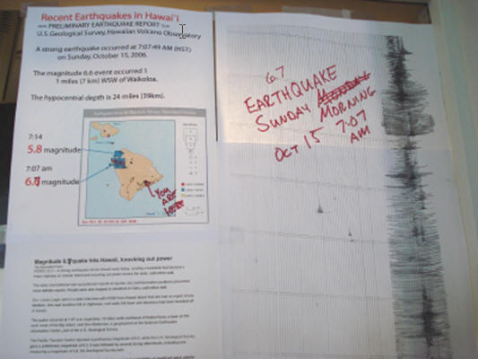
For the October 15th quake, the USGS determined that the second quake at 7:14 a.m. was triggered by the first. Aftershocks generally occur along the same rupture plane of the fault that caused the earthquake. The location of the second earthquake on October 15th was 30 kilometers north of the first and only half as deep at its rupture point within the earth's crust. HVO does not operate 24/7, but earthquakes of this magnitude brought geologists to the observatory within an hour of the first event. Earthquake assessments this big are also referred to the USGS's center in Golden, Colorado, because HVO primarily monitors events associated with the island volcanoes which do not usually produce earthquakes of this magnitude. In fact, HVO's recording stations are tuned to measure quakes of a maximum magnitude of only 4.9. These quakes sent their seismographs off scale. HVO had originally reported this quake at only 4.4. The information in the photo below was posted at the Hawaii Volcanoes National Park on Oct. 16th and you can see that the recording device truncates the data.
A more complete report from HVO about the earthquakes can be found on their website.
An earthquake of this magnitude gets people's attention. The information from HVO was immediately provided to the National Oceanographic and Atmospheric Administration's (NOAA) Pacific Tsunami Warning Center (PTWC) on Oahu and to local civil defense. PTWC may make their own assessment and in this case they issued a bulletin four minutes after the HVO report, with their own estimation of location and magnitude.
I spoke to Chip McCreary, director of the PTWC, about his responsibility for communicating the information. The PTWC continuously monitors data across the state, mostly from the Big Island since that is where the majority of seismic activity occurs. The PTWC coordinates closely with HVO. Within 20 seconds of an earthquake, they have a preliminary location, and alarm signals will notify the PTWC staff. In the case of this earthquake, signals went off before it shook the PTWC building on Oahu.
Some background information is necessary to explain NOAA's mission. In general, NOAA will inform the public about severe weather and, in this case, a tsunami. But some communication is a function of the local agencies. Primary responsibility for informing the public about emergency situations (weather, etc.) lies with civil defense (CD) which controls the EAS. Multiple communication systems exist between the PTWC and CD; phone lines are backed up with satellite and radio systems. PTWC has a dedicated phone line supported by the Federal Emergency Management Agency (FEMA). They also communicate via text bulletins through normal weather channels, such as the World Meteorological Organization (WMO), an agency of the United Nations (worldwide); and Advanced Weather Interactive Processing System (AWIPS), a National Weather Service (NWS) program. Therefore, if an emergency existed, redundant systems are in place to alert other public entities, but not the general public. This seems to be a gross oversight given that the surest way to reduce panic is to get the right information into the hands of those people most affected by the situation.
The PTWC made a preliminary tsunami threat assessment of the situation within three to four minutes of the October 15th earthquake and issued a bulletin via NOAA weather radio. It also alerted local civil defense authorities that this particular quake was not "tsunami-genic." McCreary said that once or twice a month a magnitude four tremor or above occurs on the Big Island and bulletins are regularly issued. In the aftermath of the October 15th quake, McCreary talked with the director of state civil defense to reassure him that no tsunami threat was evident. No quake of this magnitude has occurred on the Big Island for 13 years but McCreary said there is increased awareness of tsunami potential due to the tsunami that hit Indonesia in December 2004.
Significantly, PTWC does not issue any bulletin if there will NOT be a tsunami; only if a tsunami event is likely will they issue an alert. In this case there was no warning because there was no threat. While this method may be functional, it certainly does not meet the "need to know" for the general public, who were caught in an information void on that Sunday morning.
Sources for this report indicated that it was Hawaii County Civil Defense (HCCD) that had the responsibility for informing the public. In searching for information about what civil defense authorities advise the public to do in the case of an emergency, the following information is found on the Oahu CD website: "A local earthquake, i.e., one that causes you to fall or hold on to something to keep from falling, is a natural tsunami warning . . . (For) An Earthquake in Hawaiian Waters: If a significant earthquake occurs in the vicinity of the Hawaiian Islands, the Pacific Tsunami Warning Center (PTWC) will issue an URGENT TSUNAMI WARNING for those islands which could be affected by tsunami. The warning will be announced over radio through the Emergency Broadcast System in conjunction with the sounding of Civil Defense sirens. If an URGENT TSUNAMI WARNING specifically identifies Oahu, leave all evacuation zones immediately." However, two of my sources said that HCCD's system had a "glitch" due to the power outage. If HCCD had tried to issue a warning, they would have been prevented from doing so by an easily predictable power interruption. My calls to HCCD to confirm this were not returned. In this case, this was a strong earthquake, one which caused me to seek a hand hold. Therefore, by the warning advice above, I might assume that a tsunami was imminent. It's a gray area. Though no sirens sounded, was I to presume that everything was okay? And with the power out, could I presume that the sirens would sound anyway?
What We Should Expect and the Information We Should Receive
Let's start with the basics. The public should expect an emergency status notification if they are located in the affected area. The solution must work a majority of the time to inform the highest number of citizens possible. That is perhaps the 70% solution guideline. In my experience, everyone who remembered to pick up their cell phone as they evacuated their rooms used it to call someone. With over 200 million cell phones in use in the United States, there's a good chance you'll be standing next to someone with a cell phone in case you left yours behind, which is what happened to me. Most people that I saw were getting through to make a call. We can not necessarily assume that all cellular communications will be functional, but in this case backup generators were functioning at the cell towers. Other solutions might involve two-way pagers or satellite communications, but the majority of the people today are carrying cell phones.
Consider this: As my wife and I pulled away from the hotel, we switched on our Garmin i5 StreetPilot GPS-enabled personal navigation device (PND). Garmin has introduced consumer PNDs integrated with cellular communications, traffic alerts and XM Satellite services, thereby giving consumers more access to better location-aware devices that are more convenient, portable and more likely to be purchased than a NOAA weather radio. These are the devices to which communications should be sent concerning emergency evacuation routes and where to turn for more information. And, as we have already seen with services offered by some mobile virtual network operators (MVNO) such as Disney, the ability to locate family members by "pinging" their cell phones and retrieving their locations is already available.
More important, because these devices determine an exact location for the user, emergency communications from civil defense authorities can alert those who are danger within a specific geographic proximity that they will, or will NOT, be in harm's way. That was one of the main issues I had in investigating this event. It is technologically feasible to have an alert sent to me at my specific location to tell me if I am in danger. It is equally important to me to know that I am not in danger.
In this case, NOAA/PTWC should have been able to communicate to those in Hawaii County (i.e. the affected area) that the 6.7 magnitude quake was NOT tsunami-genic. And, they should have been able to do it with widely used communication tools. This would have alleviated many fears for all concerned. According to PTWC, their algorithms are sufficiently sophisticated to determine the area of a coastline that may expect a tsunami if an earthquake of sufficient magnitude occurs. If so, then the cell carriers who are now offering "geofencing" capabilities with their phone service to locate family members should be communicating with emergency authorities to provide similar alerts (via opt-in request to address privacy concerns) to the affected people during any type of emergency, local or national. It is not acceptable to be left uninformed when the technology is readily available to notify citizens in a very well-defined geographic region that they are in danger.
In addition, when NOAA sends alerts for flash floods, hurricanes or tornadoes, it is usually a county-wide notification. This proves to be overkill in most cases, especially when we are more technologically equipped in terms of geospatial situational awareness. In short, if I had a GPS-enabled device on which I received a text message alert telling me that I am within ten miles of a tsunami, I would have the information that I need to take action. And, if possible, that same alert should tell me the most viable route to take to evacuate the area because it should also be aware that some routes may be experiencing high traffic flow or blockages. Today we already have adequate real time traffic information services; in the future, a network of road sensors may have even more information to deliver to citizens.
The WARN Act
This past September, the president of the United States signed into law the WARN Act which originated in the Senate Commerce Committee. The WARN Act is supposed to encourage communication protocols and standards in a manner consistent with what I suggested above. It states, " The WARN Act will establish a network for the transmission of alerts across a broad variety of communication technologies, including wireless communication devices such as cell phones and Blackberries, the internet, digital, analog, cable, satellite television, and satellite and terrestrial radio, as well as non-traditional media such as sirens and ï¿1⁄2radios-on-a-stick.' The legislation would require that alerts provide individuals with instructions about what to do in response to the threat. The National Alert System, created under the WARN Act, will ensure that regardless of where an individual is or what kind of communication technologies they are using, they will receive a life-saving alert. Alerts would be transmitted in response to all threats to public safety, including natural disasters, man-made accidents and terrorist incidents. Alerts would only be allowed for hazards that pose a grave risk to public health and safety."
I contacted the Senate Commerce Committee concerning the implications of this legislation. My source commented that the bill came up short of its intended purpose. There are no deadlines to enforce the law or to set these recommendations in motion in private industry. The Act was supposed to push the telecommunications industry to come up with standards. But essentially the legislation has no "teeth."
Summary
Though many millions of dollars in property were destroyed, the Hawaiian earthquakes of October 15th caused no fatalities and the disruption in power was merely an inconvenience for several hours for a sparsely populated area. But it could have been a very different situation, had the events occurred during a different time of day in a more densely populated area. In my opinion, none of the solutions to warn and inform the public would be difficult to implement. My suggestions can be accomplished with technology available today. However, it will require a number of agencies and telecommunications companies to work together.
In the case of an earthquake or similar point source for an event, it is likely that the geospatial data would be available to understand location and magnitude such that the public residing in the affected geographic region could be notified by some form of communication, and one that may not depend on electrical power. Specifically in this case, information should not be limited to the NOAA weather radio system. It is not a ubiquitous form of communication, no matter how insistent NOAA is that people should buy a weather radio. To be sure, it appears to be a political problem whereby the necessary "teeth" are needed in the WARN Act or other legislation to compel government and corporations to work on solving this problem.
The WARN act emphasizes that "all" forms of communications be used to inform the public. However, we should begin with the common sense notion that a large majority of people are carrying cell phones and that most of the phones, within five years, will contain location determination chipsets such as GPS. Again in this specific case, had this been a tsunami-genic event, NOAA would have issued an alert and sirens would have sounded. However, as a tourist destination, how many visitors would have understood that the sirens indicated that a tsunami was imminent? So, there are also certain mitigating circumstances that must be factored. These "gray areas" need to be addressed, but the bottom line is that all available relevant information should be relayed the public. Wandering around clueless in an emergency situation is unacceptable.
Every organization that was mentioned above had some important piece of the puzzle, but no single agency seemed to be able to coordinate the information and use the available technology to communicate with the public. And if they had the information, a question exists as to the means they would use to communicate it most effectively. Cell phones are one possible solution but perhaps not the only solution.
The next time I confront an emergency situation I hope to be informed by an official source and in the shortest possible time. I'll gladly opt-in to an emergency notification system that can determine my location. We do that today with the 911 service that is already mandated for cellular communications. And if I am incapacitated, I want first responders to know my location as well. This is a geospatial problem and we can solve it today.
 |
It's a reasonable request, given that we've spent billions of dollars in the U.S. preparing for the next major terrorist attack, hurricane and any other human or natural disaster. If what I encountered is any indication, we are woefully unprepared to assist those affected for the next one. Based on my experience and my subsequent research for this report, the information I wanted was very much dependent on the availability of the right geospatial data. Actually, the information was readily available, but it had no way of reaching me.
This report is not meant to be an indictment of any federal, state or local agency, but a first-hand account of what I observed, what I learned subsequently, and what I know is possible to mitigate what I believe to be a problem. As many of you will understand, the technological feasibility of solving a problem is often well ahead of other more difficult challenges. Despite the investments we have supposedly made in disaster planning and response, I came away with no clear understanding of who was in charge of informing the public and how it would be done.
Let me begin with one specific observation: These quakes occurred very early on a Sunday morning on an island in the Pacific that has a low population density, not in a major metropolitan area in the middle of rush hour. Consider the consequences of this occurring in San Francisco. Consider also if the more recent, powerful 8.3 magnitude earthquake off the Kuril Islands had affected Hawaii or the west cost of the U.S. Not that these kinds of events haven't happened before, such as in the Bay Area (the 1989 Loma Prieta quake that measured 6.9), but rather consider how government agencies have supposedly been preparing to mitigate communication problems during a disaster since 9/11 and more recently with hurricane Katrina. It appears that still more needs to be done to communicate with those who are actually experiencing the disaster as it occurs or others who may be affected by its aftermath.
Background Information
I was on the Big Island of Hawaii for a vacation when the earthquakes hit. When the first quake struck, I was outside in a garden area of my hotel. I felt the initial shock wave that cascaded over the hotel roof with a sound that was unlike anything I had ever heard and was coming from all directions. Then the ground began to shake, which lasted for about 20 seconds. It was a strong "shake" but I did not completely lose my balance. When ground motion stopped, my immediate thoughts turned to finding my wife. I ran back inside the building, but the power in our hotel was out and stairwells were completely dark. My wife had been in a glass-enclosed shower at the time where she was shaken violently and did need to hold on to a bar to remain stable. The quake tossed lamps and other items to the floor, knocked pictures off the wall and cracked the dry wall in the room in several places. Fortunately, my wife and I found each other 20 minutes later outside in a parking area. At that point she said she had overheard someone talking about a tsunami and that the best thing would be to get in our car and get to higher ground. So, we sped from the hotel parking lot, passing other hotel guests who were milling around, obviously uninformed and awaiting further instruction . . . presuming someone HAD information and further instructions! As we pulled away from the hotel, we turned on the radio to find out what was going on, only to hear . . . music. Now here is where the story begins.
Information Flow Expectations
What I expected to hear was the Emergency Broadcast System. You know, "In the event of a real emergency you would be instructed to tune to "XXXX" station." Well a strong earthquake felt like a real emergency to me and we never heard that broadcast, which is now known as the Emergency Alert System (EAS). However, according to the Federal Communications Commission (FCC), "The EAS is designed to provide the President with a means to address the American people in the event of a national emergency." Okay, this was not a national emergency, but indeed it was a "local" emergency. So, who is supposed to communicate the information? What agency is charged with informing the public about a local emergency?
Driving north along the Queen Kaahumanu Highway from our hotel, we encountered several road cuts where fallen rocks and some car-sized boulders had been strewn across the road. [The photos below were taken less than 1:45 hours after the quake.] Some authority needed to know about the blockages we encountered and the danger they presented to drivers, but who do you call? 911? Eventually, one radio station, broadcasting from Honolulu and obviously not affected by the power outage (or whose backup generators were operating when others were not), did break in with news about the quakes. Mostly we learned about power outages on Oahu and the Big Island, but that was it. Then, about one hour after our departure from the hotel and while awaiting news in Waimea (see map above; 20 miles from our hotel and at an elevation of 2500 feet above sea level), we heard from that same radio station that no tsunami threat existed. I don't remember who the station said was the source of this alert but my recollection is that the disc jockey simply said "government sources." That was it. No official broadcast, no government authority verifying the statement. We still felt in the dark. If it wasn't for this single radio station, which truly did not have any authority to relay an "official" announcement, we would have been left wondering about the status of our situation. After some time, we decided to trust the Oahu disc jockey and return to the hotel to see what was going on.
 |
 |
I expected more, and as tax payers we deserve more. Was there going to be a tsunami and if so, when would it occur? If an evacuation was necessary, where should we go? What roads were open and what was the travel time to a safe haven? The reports from the Oahu radio station provided us with only the basics: The earthquake registered 6.6 (later upgraded to 6.7), and ï¿1⁄2 eventually -no tsunami threat existed. And this info only gradually trickled in to the radio station over time; the station told us what they "heard" from local citizens calling into the station but there was no "official" report. So, I began to investigate the flow of information that I had expected to receive.
Where Does the Information Flow Start?
Seismic recording stations at the USGS's Hawaiian Volcanic Observatory (HVO) on the Big Island captured the earthquake from its many recording stations on the island. I spoke with Jim Kauahikaua of HVO who said that the observatory's mission is to provide initial position and magnitude information when earthquakes occur. They usually have a position of the earthquake within five minutes of the event and will send this information to local civil defense authorities. But HVO and the USGS are not responsible for alerting the public, and merely communicate the geospatial information to other agencies.
For the October 15th quake, the USGS determined that the second quake at 7:14 a.m. was triggered by the first. Aftershocks generally occur along the same rupture plane of the fault that caused the earthquake. The location of the second earthquake on October 15th was 30 kilometers north of the first and only half as deep at its rupture point within the earth's crust. HVO does not operate 24/7, but earthquakes of this magnitude brought geologists to the observatory within an hour of the first event. Earthquake assessments this big are also referred to the USGS's center in Golden, Colorado, because HVO primarily monitors events associated with the island volcanoes which do not usually produce earthquakes of this magnitude. In fact, HVO's recording stations are tuned to measure quakes of a maximum magnitude of only 4.9. These quakes sent their seismographs off scale. HVO had originally reported this quake at only 4.4. The information in the photo below was posted at the Hawaii Volcanoes National Park on Oct. 16th and you can see that the recording device truncates the data.
 |
A more complete report from HVO about the earthquakes can be found on their website.
An earthquake of this magnitude gets people's attention. The information from HVO was immediately provided to the National Oceanographic and Atmospheric Administration's (NOAA) Pacific Tsunami Warning Center (PTWC) on Oahu and to local civil defense. PTWC may make their own assessment and in this case they issued a bulletin four minutes after the HVO report, with their own estimation of location and magnitude.
I spoke to Chip McCreary, director of the PTWC, about his responsibility for communicating the information. The PTWC continuously monitors data across the state, mostly from the Big Island since that is where the majority of seismic activity occurs. The PTWC coordinates closely with HVO. Within 20 seconds of an earthquake, they have a preliminary location, and alarm signals will notify the PTWC staff. In the case of this earthquake, signals went off before it shook the PTWC building on Oahu.
Some background information is necessary to explain NOAA's mission. In general, NOAA will inform the public about severe weather and, in this case, a tsunami. But some communication is a function of the local agencies. Primary responsibility for informing the public about emergency situations (weather, etc.) lies with civil defense (CD) which controls the EAS. Multiple communication systems exist between the PTWC and CD; phone lines are backed up with satellite and radio systems. PTWC has a dedicated phone line supported by the Federal Emergency Management Agency (FEMA). They also communicate via text bulletins through normal weather channels, such as the World Meteorological Organization (WMO), an agency of the United Nations (worldwide); and Advanced Weather Interactive Processing System (AWIPS), a National Weather Service (NWS) program. Therefore, if an emergency existed, redundant systems are in place to alert other public entities, but not the general public. This seems to be a gross oversight given that the surest way to reduce panic is to get the right information into the hands of those people most affected by the situation.
The PTWC made a preliminary tsunami threat assessment of the situation within three to four minutes of the October 15th earthquake and issued a bulletin via NOAA weather radio. It also alerted local civil defense authorities that this particular quake was not "tsunami-genic." McCreary said that once or twice a month a magnitude four tremor or above occurs on the Big Island and bulletins are regularly issued. In the aftermath of the October 15th quake, McCreary talked with the director of state civil defense to reassure him that no tsunami threat was evident. No quake of this magnitude has occurred on the Big Island for 13 years but McCreary said there is increased awareness of tsunami potential due to the tsunami that hit Indonesia in December 2004.
Significantly, PTWC does not issue any bulletin if there will NOT be a tsunami; only if a tsunami event is likely will they issue an alert. In this case there was no warning because there was no threat. While this method may be functional, it certainly does not meet the "need to know" for the general public, who were caught in an information void on that Sunday morning.
Sources for this report indicated that it was Hawaii County Civil Defense (HCCD) that had the responsibility for informing the public. In searching for information about what civil defense authorities advise the public to do in the case of an emergency, the following information is found on the Oahu CD website: "A local earthquake, i.e., one that causes you to fall or hold on to something to keep from falling, is a natural tsunami warning . . . (For) An Earthquake in Hawaiian Waters: If a significant earthquake occurs in the vicinity of the Hawaiian Islands, the Pacific Tsunami Warning Center (PTWC) will issue an URGENT TSUNAMI WARNING for those islands which could be affected by tsunami. The warning will be announced over radio through the Emergency Broadcast System in conjunction with the sounding of Civil Defense sirens. If an URGENT TSUNAMI WARNING specifically identifies Oahu, leave all evacuation zones immediately." However, two of my sources said that HCCD's system had a "glitch" due to the power outage. If HCCD had tried to issue a warning, they would have been prevented from doing so by an easily predictable power interruption. My calls to HCCD to confirm this were not returned. In this case, this was a strong earthquake, one which caused me to seek a hand hold. Therefore, by the warning advice above, I might assume that a tsunami was imminent. It's a gray area. Though no sirens sounded, was I to presume that everything was okay? And with the power out, could I presume that the sirens would sound anyway?
What We Should Expect and the Information We Should Receive
Let's start with the basics. The public should expect an emergency status notification if they are located in the affected area. The solution must work a majority of the time to inform the highest number of citizens possible. That is perhaps the 70% solution guideline. In my experience, everyone who remembered to pick up their cell phone as they evacuated their rooms used it to call someone. With over 200 million cell phones in use in the United States, there's a good chance you'll be standing next to someone with a cell phone in case you left yours behind, which is what happened to me. Most people that I saw were getting through to make a call. We can not necessarily assume that all cellular communications will be functional, but in this case backup generators were functioning at the cell towers. Other solutions might involve two-way pagers or satellite communications, but the majority of the people today are carrying cell phones.
Consider this: As my wife and I pulled away from the hotel, we switched on our Garmin i5 StreetPilot GPS-enabled personal navigation device (PND). Garmin has introduced consumer PNDs integrated with cellular communications, traffic alerts and XM Satellite services, thereby giving consumers more access to better location-aware devices that are more convenient, portable and more likely to be purchased than a NOAA weather radio. These are the devices to which communications should be sent concerning emergency evacuation routes and where to turn for more information. And, as we have already seen with services offered by some mobile virtual network operators (MVNO) such as Disney, the ability to locate family members by "pinging" their cell phones and retrieving their locations is already available.
More important, because these devices determine an exact location for the user, emergency communications from civil defense authorities can alert those who are danger within a specific geographic proximity that they will, or will NOT, be in harm's way. That was one of the main issues I had in investigating this event. It is technologically feasible to have an alert sent to me at my specific location to tell me if I am in danger. It is equally important to me to know that I am not in danger.
In this case, NOAA/PTWC should have been able to communicate to those in Hawaii County (i.e. the affected area) that the 6.7 magnitude quake was NOT tsunami-genic. And, they should have been able to do it with widely used communication tools. This would have alleviated many fears for all concerned. According to PTWC, their algorithms are sufficiently sophisticated to determine the area of a coastline that may expect a tsunami if an earthquake of sufficient magnitude occurs. If so, then the cell carriers who are now offering "geofencing" capabilities with their phone service to locate family members should be communicating with emergency authorities to provide similar alerts (via opt-in request to address privacy concerns) to the affected people during any type of emergency, local or national. It is not acceptable to be left uninformed when the technology is readily available to notify citizens in a very well-defined geographic region that they are in danger.
In addition, when NOAA sends alerts for flash floods, hurricanes or tornadoes, it is usually a county-wide notification. This proves to be overkill in most cases, especially when we are more technologically equipped in terms of geospatial situational awareness. In short, if I had a GPS-enabled device on which I received a text message alert telling me that I am within ten miles of a tsunami, I would have the information that I need to take action. And, if possible, that same alert should tell me the most viable route to take to evacuate the area because it should also be aware that some routes may be experiencing high traffic flow or blockages. Today we already have adequate real time traffic information services; in the future, a network of road sensors may have even more information to deliver to citizens.
The WARN Act
This past September, the president of the United States signed into law the WARN Act which originated in the Senate Commerce Committee. The WARN Act is supposed to encourage communication protocols and standards in a manner consistent with what I suggested above. It states, " The WARN Act will establish a network for the transmission of alerts across a broad variety of communication technologies, including wireless communication devices such as cell phones and Blackberries, the internet, digital, analog, cable, satellite television, and satellite and terrestrial radio, as well as non-traditional media such as sirens and ï¿1⁄2radios-on-a-stick.' The legislation would require that alerts provide individuals with instructions about what to do in response to the threat. The National Alert System, created under the WARN Act, will ensure that regardless of where an individual is or what kind of communication technologies they are using, they will receive a life-saving alert. Alerts would be transmitted in response to all threats to public safety, including natural disasters, man-made accidents and terrorist incidents. Alerts would only be allowed for hazards that pose a grave risk to public health and safety."
I contacted the Senate Commerce Committee concerning the implications of this legislation. My source commented that the bill came up short of its intended purpose. There are no deadlines to enforce the law or to set these recommendations in motion in private industry. The Act was supposed to push the telecommunications industry to come up with standards. But essentially the legislation has no "teeth."
Summary
Though many millions of dollars in property were destroyed, the Hawaiian earthquakes of October 15th caused no fatalities and the disruption in power was merely an inconvenience for several hours for a sparsely populated area. But it could have been a very different situation, had the events occurred during a different time of day in a more densely populated area. In my opinion, none of the solutions to warn and inform the public would be difficult to implement. My suggestions can be accomplished with technology available today. However, it will require a number of agencies and telecommunications companies to work together.
In the case of an earthquake or similar point source for an event, it is likely that the geospatial data would be available to understand location and magnitude such that the public residing in the affected geographic region could be notified by some form of communication, and one that may not depend on electrical power. Specifically in this case, information should not be limited to the NOAA weather radio system. It is not a ubiquitous form of communication, no matter how insistent NOAA is that people should buy a weather radio. To be sure, it appears to be a political problem whereby the necessary "teeth" are needed in the WARN Act or other legislation to compel government and corporations to work on solving this problem.
The WARN act emphasizes that "all" forms of communications be used to inform the public. However, we should begin with the common sense notion that a large majority of people are carrying cell phones and that most of the phones, within five years, will contain location determination chipsets such as GPS. Again in this specific case, had this been a tsunami-genic event, NOAA would have issued an alert and sirens would have sounded. However, as a tourist destination, how many visitors would have understood that the sirens indicated that a tsunami was imminent? So, there are also certain mitigating circumstances that must be factored. These "gray areas" need to be addressed, but the bottom line is that all available relevant information should be relayed the public. Wandering around clueless in an emergency situation is unacceptable.
Every organization that was mentioned above had some important piece of the puzzle, but no single agency seemed to be able to coordinate the information and use the available technology to communicate with the public. And if they had the information, a question exists as to the means they would use to communicate it most effectively. Cell phones are one possible solution but perhaps not the only solution.
The next time I confront an emergency situation I hope to be informed by an official source and in the shortest possible time. I'll gladly opt-in to an emergency notification system that can determine my location. We do that today with the 911 service that is already mandated for cellular communications. And if I am incapacitated, I want first responders to know my location as well. This is a geospatial problem and we can solve it today.
From Our Homepage
Saying Farewell to an Amazing Journey
Communicating with Maps
Is There a GIS Career Ladder?
What does it mean to be geospatially smart? Series
Ways Real Estate and Property Developers Utilize Melissa GeoData for Data-Driven Decisions
Unlocking Value From Daily Satellite Imagery and Insights
Maximizing the Value of Your Address Data with Geo Addressing
How Indoor Mapping Enhances the Security of Smart Buildings
Look Ahead: AI, Location Intelligence and Efficiency
Collaboration Takes on Sea Level Rise & Dynamic Technology Environments
Brownies for Brownfields
Has Everything Been Mapped Already?
How Is Data Literacy Changing in an Artificial Intelligence Landscape
Portfolios for GIS Professionals: More Than Just Maps
How to Create a Distance Matrix in QGIS - A Step-by-Step Guide
7 Ideas for Bringing GIS into the K-12 Classroom
The Geography of Movement