A major study of subsea mapping data conducted by the University of New Hampshire under a grant from the National Oceanic and Atmospheric Administration (NOAA) used GIS technology to provide the United States the information needed to decide how much new seafloor mapping is required before pursuing a claim that could extend the U.S.jurisdiction over the seabed and subsoil on the continental margin beyond the current Exclusive Economic Zone (EEZ).
By international law, coastal nations claim sovereignty over the resources contained in the offshore areas reaching 200 nautical miles from their shorelines.This area, called the EEZ, includes mineral, oil and gas resources found below the seafloor.However, under Article 76 of the United Nations Convention on the Law of the Sea (UNCLOS), a nation may extend their jurisdiction over the seabed and subsoil in such a way that it reaches beyond its EEZ if a complex set of criteria involving water depth, seafloor shape and sediment thickness are meet.
Although the United States has yet to ratify the 25-year-old UNCLOS article, it recently renewed interest in submitting a claim for an extended jurisdiction.It is worth noting that a 2001 study estimated some $1.3 trillion worth of resources, which could be extracted from the larger zone. In December 2001, at the direction of the U.S.Congress NOAA funded the Center for Coastal and Ocean Mapping/Joint Hydrographic Center (CCOM/JHC) at the University of New Hampshire to analyze the availability and quality of hydrographic, geologic and geophysical data that would be required to submit a claim.
In less than six months, our team at CCOM/JHC gathered enormous volumes of relevant data from several sources around the country and loaded these data sets into an Oracle9i database for archiving, sorting and accessing. We linked this database to Intergraph's GeoMedia Professional GIS system to analyze and merge the subsurface data, creating dozens of maps revealing where data is sufficient to potentially stake a claim and where additional or higher quality data may be needed.
Our results indicate there is great potential for satisfying UNCLOS requirements in at least eight areas of the U.S.coastline, however, we have also suggested collecting new data in these regions.This information has been submitted to the U.S.Congress for use in deciding how the U.S. will proceed on UNCLOS and Article 76.
Extending the EEZ
UNCLOS Article 76 essentially attempts to redefine the legal definition of the continental shelf beyond the currently assigned 200 nautical mile limit.In summary, the convention defines three parameters for basing a claim and allows the coastal state to apply whichever is most advantageous at any given location, which means that many combinations of the criteria listed below can be used:
- Foot of Slope (FOS) - By finding the point where the continental slope ends and levels out onto the ocean floor, a nation may extend its EEZ another 60 nautical miles seaward from that point.
- Sediment Thickness - Where sediment has flowed outward from the continental shelf and down the slope, a nation may extend its EEZ to the point where the thickness of sediment equals one percent of the distance from the FOS.
- Cutoff Lines - Regardless of the FOS and sediment thickness a nation may not extend its EEZ beyond the most seaward of 100 nautical miles past where water depth reaches 2500 meters (the 2500 m isobath), or more than 350 nautical miles from the shoreline.
Based on these criteria, the two data sets that are most critical in staking a claim are bathymetry and seismic profiles.Bathymetry measures the depth of water and therefore provides the 2500 m isobath and also enables a user to pinpoint the FOS.Seismic reflection surveys are the most practical means of determining sediment thickness.
A third important, although more readily accessible data set, is the Territorial Sea Baseline - normally the low-water line - which is used to measure standard distances from the shoreline such as the 200 nautical miles EEZ and the 350 nautical miles cutoff.
The first phase of our project was consumed with locating and obtaining all bathymetric, seismic and other geophysical data available for the United States and its territories.We worked with NOAA's National Geophysical Data Center (NGDC) in Boulder, Colo., which serves as a central repository for many of the sought-after data sets, and the U.S.Geological Survey who are responsible for seismic data in the U.S.Other consultants assisted in finding many additional sources of unclassified data not held at the time by NGDC.
Although committed to procuring as much U.S.data as possible, our researchers are experienced in subsurface geomorphology and we knew early on that certain parts of the coastline could be eliminated from consideration.Subduction zones, such as those along the Pacific side of the Aleutian Islands and offshore from Puerto Rico, create sharp drop-offs from the Coastal Shelf to substantial depths much closer to shore than the current 200 nm limit, making it impossible to extend the EEZ in those areas.
Mapping with GIS
We obtained copies of relevant data sets and gathered them into a centralized Oracle database established at the CCOM/JHC laboratory in New Hampshire. The volume and diversity of data were staggering, including nearly 40,000 seismic tracklines, 6000 bathymetric survey polygons and millions of individual sonar soundings.The diversity of these data cannot be overstated - they represent literally thousands of acquisition methods, data types, file formats and map projections.
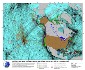
Map above depicts the amount of tracklines in the data base and available bathymetric data
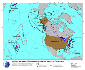
Map above shows the detailed study areas and where new surveys are suggested
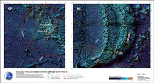
Maps above shows the bathymetry from ETOPO2 with all our tracklines over Kingman Reef and Mariana Islands
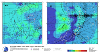
Maps above show sediment thickness from NGDC database and all seismic tracklines over the same area
Perhaps too often associated with land mapping, GIS is the most efficient technology available to organize, georeference and visualize these subsurface data sets.Intergraph's GeoMedia Professional package was used in this project for its ability to access multiple raster and vector data files in a variety of formats and quickly convert them on the fly into maps of desired datum, projection or scale.The open architecture of GeoMedia also allowed us to easily integrate into the GIS environment results from Caris LOTS, a specialized software package for geodetic computations of the complex Law of the Sea limits.
With our 6-month deadline rapidly approaching, we relied on the speed of GeoMedia to process large numbers of huge data files and produce a series of overview maps showing the geographic distribution of the obtained bathymetry, seismic surveys and other data sets.Without this quick mapping capability, we may not have met our deadline.These overviews were crucial for providing the first indication of where to focus our evaluation of existing data and where to recommend collection of additional data.
The first stage of real analysis involved using the GIS to overlay water depth measurements, sediment thickness profiles, existing territorial baselines, cutoff lines and the current EEZ boundary.By projecting these elements on a common map, we could easily see where the United States has the greatest potential for filing claims.Tagged for further study were most of the East Coast, the Gulf of Mexico, the Alaskan margin, the Aleutian Basin, the Arctic margin and areas around the Guam and Palmyra Atolls.
Mapping Data Quality
Focusing on these regions of interest, our GIS analysis then turned to assessing whether the available data were sufficient to file a claim. Unfortunately, Article 76 offers little guidance in this realm, stating only that the data submitted must be "acceptable" to the Commission.In terms of acceptability, the Commission merely states that points along a claim line must be spaced no greater than 60 nautical miles.The Commission also suggests that bathymetric data supporting a claim should meet International Hydrographic Organization (IHO) specifications for accuracy.
To examine density, we called on the GIS to map the bathymetry data with color coding by source.This revealed that if density alone were taken into account, existing bathymetric data is sufficient to submit claims for our target areas, with the exception of the Arctic.However, given the age of many data sets and the outdated methods used to acquire and locate navigation points, we became concerned over data quality issues.
Assessing the quality of seismic data exceeds the capability of GIS analysis and requires computational work that we have recommended for assignment to the U.S.Geological Survey (USGS).However, a rough estimate of the quality of bathymetry data based on information of used ship navigation and depth measurement systems is possible to achieve and visualize using GIS, and this is where GeoMedia's® data handling capabilities played their most important role.
In addition to storing bathymetric and other geophysical data sets in the project database, we also archived the metadata associated with each file.This provided us with exhaustive information relating to when and how each depth measurement was acquired.GeoMedia allowed us to create maps of bathymetry quality based on specific attributes in the metadata files.
For example, survey accuracy was a major concern regarding the depth measurements given the fact that most of these data sets were collected prior to the availability of GPS.This meant that a wide variety of navigational techniques, including the sextant, were used to fix location points to the data points.For one map, we ranked navigational techniques by their accuracy and then queried the database and used GeoMedia to create a color-coded map illustrating where the most and least accurate data sets occurred.
By mapping many different variations of data quality based on metadata files, we quickly began seeing where poor quality data might jeopardize an UNCLOS claim.From the outset of this project, we proposed to take a conservative view of data availability, and we considered any data of questionable quality as a data gap.
Congress, NOAA Now Reviewing
We submitted our report to Congress in May 2002 with the conclusion that there are several offshore areas of the United States with the potential for filing Article 76 claims.In order to be able to submit a high-quality and territorially optimized claim we recommend additional bathymetric survey work using modern multibeam sonar technology along in our report defined critical regions of these offshore areas.NOAA and the U.S.Congress is now reviewing our report and considering alternatives.
Jakobsson, M., Mayer, L., and Armstrong, A., in press, Analysis of Data Relevant to Extending a Coastal State's Jurisdiction Over the Seafloor Under Law of the Sea Article 76, International Hydrographic Review, v. 4(1).
The report is available at http://www.ccom.unh.edu/unclos/index.htm
Report citation:
Jakobsson, M., Mayer, L., and Armstrong, 2002, The Compilation and Analysis of Data Relevant to a U.S.Claim Under United Nations Law of the Sea Article 76: Maps, University of New Hampshire Report for the US Congress, 40 Maps.Mayer, L., Jakobsson, M., and Armstrong, A., 2002, The Compilation and Analysis of Data Relevant to a U.S.Claim Under United Nations Law of the Sea Article 76: A Preliminary Report, University of New Hampshire Report for the US Congress, p.1-75 plus Appendices.