Microsoft Virtual Earth and Autodesk
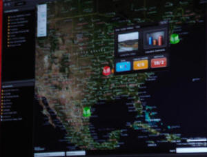
Microsoft demonstrated how to use Virtual Earth to interface to Autodesk's project management solutions, thereby providing what they called an "uber user" perspective. The scenario given by Eddie Amos, senior director, developer and platform evangelist, took the entire lifecycle of a building project and reviewed it from a geographic perspective. Virtual Earth was used to review the locations of all commercial properties for which a project manager is responsible. The status of certain tasks and deliverables from various contractors who are in different locations can be understood by color-coded icon. The icon may be linked to approval forms or DWF files. Reports or design drawings from other project team members can be dragged and dropped onto the icon to complete the task or trigger other actions that need to be performed.
Support for a new drawing format, DWFx, is built into Microsoft's new Vista operating system. According to the Autodesk press release, "DWF files published to the XPS specification can be automatically opened and viewed directly in Windows Vista using the XPS Viewer. Project team members can use Microsoft Corp.'s forthcoming software right out of the box to review designs in digital format. As part of the announcement, Autodesk will incorporate support for publishing DWF files to the XPS specification." All drawing or design files associated with a particular location can be attached to a specific geographic location. Using Virtual Earth, the user can zoom to ever higher detail at the city block or building level thus revealing all associated drawing files.
 |
HP Workstations
Paul Renaud, Hewlett-Packard's director of segment marketing for workstations, provided an overview of how HP and Autodesk work together to facilitate work on 3D graphic cards and remote access for better collaboration among project participants. Renaud emphasized how more users are requiring 3D visualization, thus driving higher compute requirements. Multiple displays and advanced simulation combined with photo realism are contributing to the demand for faster processors. HP is offering workstations using the Intel Xeon Multi-core processor. This is a single processor offered with either two or four processing cores but the effect is like having multiple processors in a single desktop computer. The processor allows users to invoke an "isolate" command to enable work on a single design element so that any change to a specific design element does not require the user to wait for the model to be entirely updated. The time required for these changes has gone from minutes to seconds.
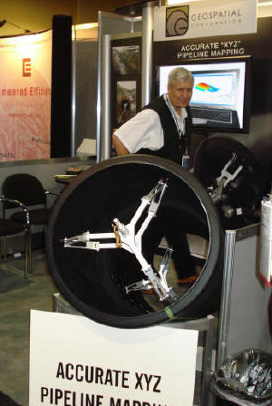
Geospatial Corporation
Geospatial Corporation's DuctRunner Smart Probe technology offers a gyroscopically controlled, un-tethered device that captures centerline information by running a probe through a pipeline. The probe will capture location and elevation data of the pipe in addition to angular and linear dimensions. Different body styles of the probe are available depending on the inside diameter of the pipe, which can be as narrow as 5 centimeters or as large as 122 centimeters. The data can be integrated with most any CAD or GIS software.
 |
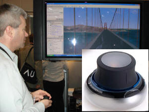
3DConnexion
3DConnexion's SpaceNavigator is designed for the user who wants a more immersive media experience when working with simulation models or, in the case of geospatial technology, to more easily navigate 3D perspective views such as those facilitated by ArcGIS Explorer, Microsoft's Virtual Earth or Google Earth. The device connects by a USB port and weighs 16.9 ounces so it is designed to replace the sometimes awkward ergonomics of a mouse when trying to zoom, pan and rotate at the same time. Rory Dooley, president of 3DConnexion, explained that the company recently reduced the price of the device from $500 to $59 to more closely approximate the market's intrinsic price point. The company is no longer trying to push the productivity aspects of the device, which he said were the company's original justification for the higher price. Now, the company understands that it is considered yet another interface device, like a keyboard or mouse, and therefore should be priced accordingly. However, with users depending more on 3D visualization to demonstrate a project's value, this tool would seem to be a "must" in helping to create the intended experience that comes with higher expectations of a more discerning and technically savvy decision maker.
 |
[Disclosure: Autodesk paid for travel and lodging for this event.]
From Our Homepage
Saying Farewell to an Amazing Journey
Communicating with Maps
Is There a GIS Career Ladder?
What does it mean to be geospatially smart? Series
Ways Real Estate and Property Developers Utilize Melissa GeoData for Data-Driven Decisions
Unlocking Value From Daily Satellite Imagery and Insights
Maximizing the Value of Your Address Data with Geo Addressing
How Indoor Mapping Enhances the Security of Smart Buildings
Look Ahead: AI, Location Intelligence and Efficiency
Collaboration Takes on Sea Level Rise & Dynamic Technology Environments
Brownies for Brownfields
Has Everything Been Mapped Already?
How Is Data Literacy Changing in an Artificial Intelligence Landscape
Portfolios for GIS Professionals: More Than Just Maps
How to Create a Distance Matrix in QGIS - A Step-by-Step Guide
7 Ideas for Bringing GIS into the K-12 Classroom
The Geography of Movement