CRESTA zones provide a universal standard for the exchange of aggregated, insurance-relevant information among insurers and reinsurers.
The worldwide demand for a precise cartographic basis for estimating risk and damages from natural catastrophes continues to grow. The new CRESTA maps offer users from the insurance and reinsurance branches a valuable basis for calculating insurance policies.
Previously, zones were available for 86 countries, along with supplementary subzones. As a means of offering more value to users, the reformed 2013 CRESTA zones are now defined based on official boundaries rather than being risk-dependent.
Postcodes and administrative regions offer worldwide coverage at a detailed level. These are also commonly used and clearly defined regional levels for which a high-quality cartographic basis is available thanks to GfK, the official supplier of the worldwide CRESTA zones.
The new CRESTA zones are available in two resolutions: high resolution (HighRes) and low resolution (LowRes). The high-resolution zones are ideal for data exchange and natural catastrophe modeling. The low-resolution zones are well suited to accumulation control and cartographic illustrations. [Refer to map below; Click for larger image].
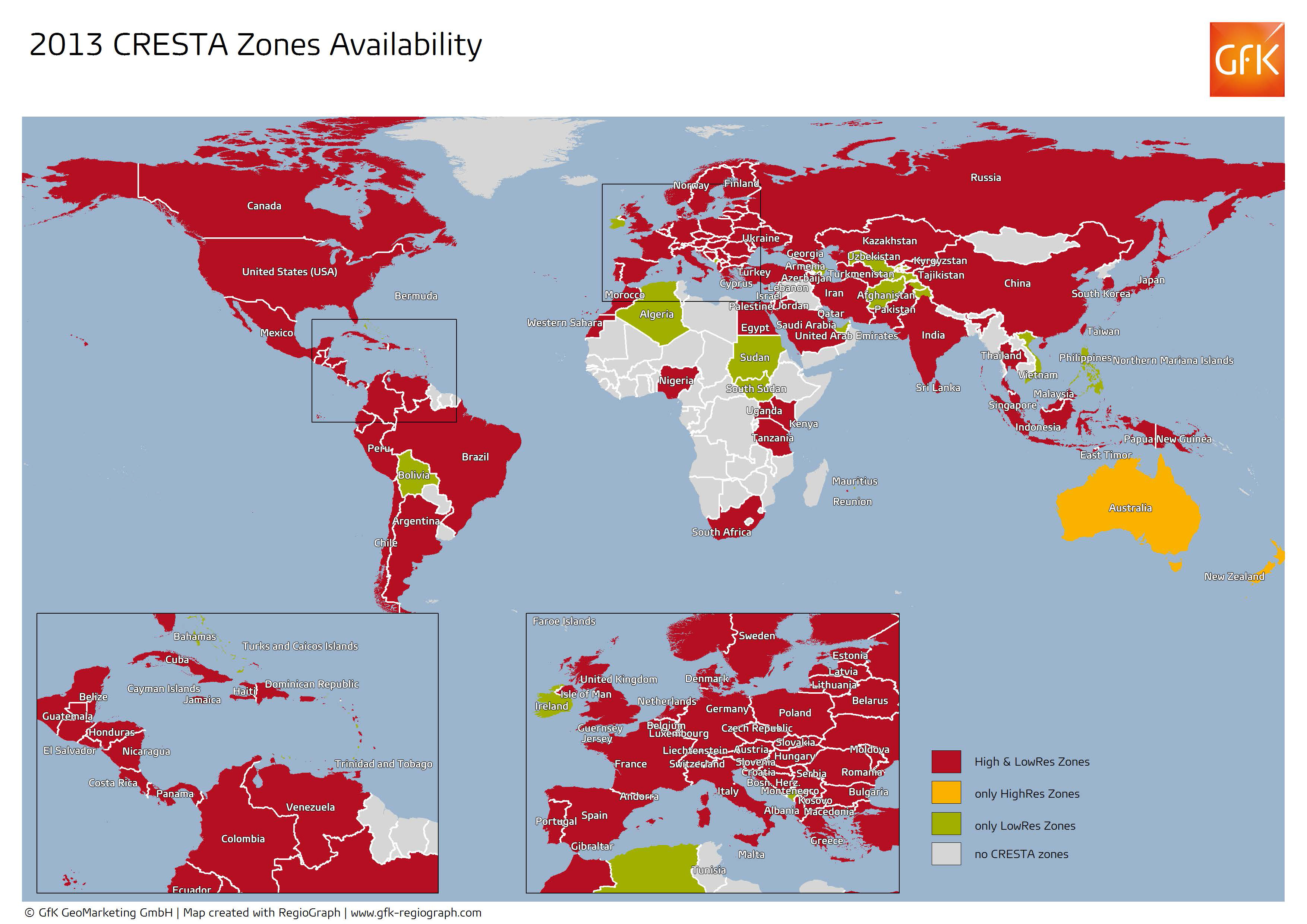
Figure 1: Digital maps of CRESTA zones comprise the basis for natural catastrophe modeling, accumulation control and cartographic illustrations. As of 2013, there are high-resolution (HighRes) and low-resolution (LowRes) CRESTA zones.
In the past, users had access to approximately 43,000 old zones; following the reform, this has been expanded to around 250,000 high-resolution zones.
CRESTA.org - online geodatabase for the reinsurance industry
The expanded CRESTA database now offers coverage of 137 countries. Users from the insurance and reinsurance branches can access the database free of charge at www.cresta.org. This service is sponsored by Munich Re and Swiss Re.
To facilitate the transition to the new zones, the CRESTA website allows users to access and cartographically display both the new and (on a temporary basis) the old zones and subzones.
CRESTA additionally offers conversion tables for linking the old and new zones. Users can also display aggregated insured sums per CRESTA zone by uploading a standardized ACORD (Association for Cooperative Operations Research and Development) table.
One important new and free feature lets users quickly and easily determine the CRESTA zone for any entered coordinates.
ABOUT CRESTA
Founded in 1977, the independent CRESTA initiative dedicates itself to providing a universal standard for accumulation control of natural hazards. The acronym "CRESTA" stands for Catastrophe Risk Evaluating and Standardizing Target Accumulations.
Munich Re and Swiss Re alternate responsibility for the CRESTA secretariat, with Munich Re taking charge in 2013. The secretariat is currently headed by Dr. Jürgen Schimetschek, Risk Manager in Corporate Underwriting/Geospatial Solutions.
More information at www.cresta.org
Case study (pdf) reprinted with permission from GfK Geomarketing GmbH.
Explore more:
Location Intelligence
From Our Homepage
Saying Farewell to an Amazing Journey
Communicating with Maps
Is There a GIS Career Ladder?
What does it mean to be geospatially smart? Series
Ways Real Estate and Property Developers Utilize Melissa GeoData for Data-Driven Decisions
Unlocking Value From Daily Satellite Imagery and Insights
Maximizing the Value of Your Address Data with Geo Addressing
How Indoor Mapping Enhances the Security of Smart Buildings
Look Ahead: AI, Location Intelligence and Efficiency
Collaboration Takes on Sea Level Rise & Dynamic Technology Environments
Brownies for Brownfields
Has Everything Been Mapped Already?
How Is Data Literacy Changing in an Artificial Intelligence Landscape
Portfolios for GIS Professionals: More Than Just Maps
How to Create a Distance Matrix in QGIS - A Step-by-Step Guide
7 Ideas for Bringing GIS into the K-12 Classroom
The Geography of Movement