Unlike many natural disasters, human-induced disasters such as the terrorist attack on September 11, 2001, occur on the micro-space of multi-level structures (such as buildings) in urban areas, where evacuation is critical.Many GIS-based emergency management systems for earthquake, floods and other disasters have been developed using 2D GIS with 3D visualization systems.The systems have limitations in representing the complex internal structure of buildings in 3D. Additional technology is needed to handle emergency situations in micro-scale environments such as large public buildings, shopping centers, underground metro-subways and garages.This article introduces an 'intelligent' emergency evacuation system of complex buildings using 3D GIS and Intelligent Transportation System (ITS) technologies, called an Intelligent Building Evacuation (IBE) System.
Evacuation is an important component of emergency management.Since the early 1980s, much GIS-based research has been conducted to resolve evacuation problems at an urban scale.Evacuation plans have been developed in 2D environments to deal with vehicle movements on street networks.Evacuation tools have been implemented to prepare evacuation plans for evacuations in micro-space, such as the inside of complex buildings and ships.They are pre-defined evacuation plans designed to operate under ideal situations regardless of what has happened or is happening within the buildings, and are not intelligent emergency response systems (Pu and Zlatanova, 2005).
Kwan and Lee (2005) proposed GIS-based Intelligent Emergency Response System (GIERS) to evaluate the potential benefit of a 3D GIS for improving the speed of emergency response.The impact of two types of uncertainty was evaluated: street network uncertainty (vehicle movements in 2D space); and route uncertainty within built environments (pedestrian movements in 3D space).The experiment demonstrated that response delays within multi-level structures due to indoor route uncertainty can be much longer than delays incurred on the ground.The results also showed that extending conventional 2D GIS to 3D GIS to represent the internal structures of high-rise buildings can significantly improve the overall speed of rescue operations.
The IBE system this article discusses, is the logical continuation of that research, and is a spatial decision support system that facilitates coordination and implementation of emergency response operations such as pedestrian evacuation and rescue within micro-scale urban indoor space.It incorporates dynamic geospatial data about the emergency situation, and spatial-temporal analytical and modeling capabilities.These include a navigable 3D GIS, a dynamic geospatial database, data positioning in real-time, analytical models to simulate possible trajectories of change and to formulate alternative decision scenarios, and a distributed information architecture.
To base an evacuation model on spatial analysis and modeling, a navigable data model of the building interior(s) and a dynamical geospatial database are needed.Determining the safest and most efficient way to evacuate a building can be dealt with as a transportation problem, using a pedestrian navigation model called an Indoor Navigable Data Model (INDM).An INDM is used in Graph Theory and 3D Geometric Network Data Model (GNM) (Lee, 2004a).The GNM is based on a node-relation structure (Lee, 2001) and was developed to represent connectivity relationships among 3D spatial entities in built-environments.
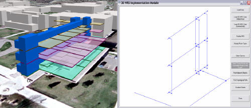
To develop an INDM based on GNM, straight medial axis transformation modeling is used to represent horizontal paths (corridors) on the floor of the building, and a 3D Poincäre Duality model is used to represent the connectivity relationships between horizontal paths (rooms to hallways) and vertical paths (stairwells and elevators among floors).Figure 1 shows an example of an INDM generated for the area surrounding Trafton East Hall, located at Minnesota State University in Mankato (Lee 2004b).The 3D model of the MSU-Mankato campus is based on an ESRI ArcView 3D Shapefile data model, with links to a GIS database including the Campus Map and floor layout information.
Figure 1(a) displays the transport routes within Trafton East Hall in 3D View, and Figure 1(b) depicts the extracted INDM of the study area. The figure presents the connectivity relationships among transport routes (such as corridors, stairways and elevators) inside the building and a street network in the study area.The 3D GNM is generated by integrating the 3D internal network of the building with the 2D network of the ground transportation system.
Figure 1a (left) and b (right): Indoor Navigable Data Model (Lee, 2004b).(Click for larger image)
The INDM consists of geospatial object-object relationships and geospatial object-event participation relationships.The Network class (NetworkClass) is composed of Node and Edge Classes.The Node class has four subclasses: NotePT, InterPT, EventPT and DoorPT classes, while the Edge class has two subclasses: MoveEdge and ConnectEdge classes.The NotePT objects are source or destination nodes representing a source of people (workplaces, rooms or suites) and building exits, respectively. The InterPT objects are intermediate nodes in the network, and DoorPTs represents doors between workplaces and halls and stairwells.The EventPT objects are bottlenecks (traffic congestion areas) or disaster sites.The MoveEdge objects represent hallways in horizontal movements, and stairwells or elevators in vertical movements, while the ConnectEdges represent paths of movements between nodes and the MoveEdges.
The INDM is a digital geographic database of a pedestrian transportation system that supports escape and rescue within a building, and is integrated to other information from intelligent building systems, 3D cadastre systems, and other emergency management systems.The INDM requires the following three functions:
- Supply a 3D location to locate rescue personnel and/or disaster.
- 'Map matching' to 'snap' bottlenecks or disaster site positions to the nearest location on a network segment when its reported, or estimated location outside the network.
- An indoor navigation function to identify feasible and safe routes within a multi-level structure and to provide navigation guidance for rescue personnel.
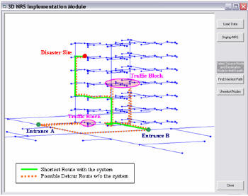
The IBE system based on the INDM is designed with six core services: a gateway/GUI, a reference database (to access information related to the input addresses), 3D geocoding conversion from address to 3D coordinates, map matching (to connect or snap event locations to the network), presentation (2D and 3D visualization), and 3D navigation (spatial queries to define optimal routes within 3D indoor). An experimental implementation of an emergency response system based on the INDM took in downtown Columbus, Ohio (Kwan and Lee, 2005).The study assumed that a 250-pound high-explosive bomb exploded on the 42nd floor of the Franklin County Municipal Building (labeled "Disaster Site" in Fig.2), and that the shock also caused minor damage on some other floors as well as to some of the stairways inside the building. Following is a description of what happened during the experiment. After arriving at the disaster building at Entrance A, emergency responders discover that this entrance was blocked by debris and couldn't be used to reach the disaster site on the 42nd floor.They then walk to another side of the building in order to use Entrance B. They blocked at the 28th floor as they attempt to walk up to the 42nd floor using the stairway.They then walked down to the ground level and used another stairway to go up again.They were blocked on the 28th floor again and had to walk down a couple of floors and walk through some corridors to go up using another stairway.The additional delay between the optimal route (green line) and the hypothetical detour route (red dotted line) represents the effect of entry point uncertainty and route uncertainty.The purpose of the study was to evaluate the potential benefit of a navigable 3D GIS for improving the speed of emergency response.The benefit of the system based upon an integrated and navigable 3D network data model would be even greater when the real world scenario is worse than that conceived in this experiment.The evacuation can begin long before emergency responders arrive at the disaster site, which could save many lives, especially if the building is becoming structurally unstable after a bomb attack.
Figure 2: The shortest path between two entrances (A and B) and a disaster site inside the building (Kwan and Lee, 2005).(Click for larger image) Although future research is needed to develop a real-time emergency response system for building evacuations, the INDM is an indispensable and significant step toward this development.
References:
Kwan, M-P.and Lee, J., 2005, Emergency response after 9/11: the potential of real-time 3D GIS for quick emergency response in micro-spatial environments, Computers, Environment and Urban Systems, 29, pp 93-113.
Lee, J., 2001, A 3D Data Model for Representing Topological Relationships Between Spatial Entities in Built-Environments, unpublished Ph.D.Dissertation, Department of Geography, The Ohio State University
Lee, J., 2004a, "A Spatial Access Oriented Implementation of a Topological Data Model for 3D Urban Entities" GeoInformatica 8:3, pp 235-262
Lee, J., 2004b "3-D GIS for Geo-coding Human Activity in Micro-scale Urban Environments" in Geographic Information Sciences: Springer's Lecture Notes in Computer Science Computers (LNCS 3234).Eds M Egenhofer, C Freksa and H Miller (Springer, New York) pp 162-178
Pu, S.and Zlatanova, S., 2005, "Evacuation Route Calculation of Inner Buildings" in Geo-Information for disaster management.Eds P. van Oosterom, S.Zlatanova and E.M.Fendel (Springer Verlag, Heidelberg) pp.1143-1161.