State Program
|
Accomplishments & Programs
|
Photo & Plans
|
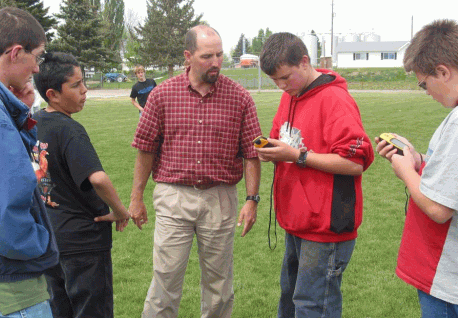
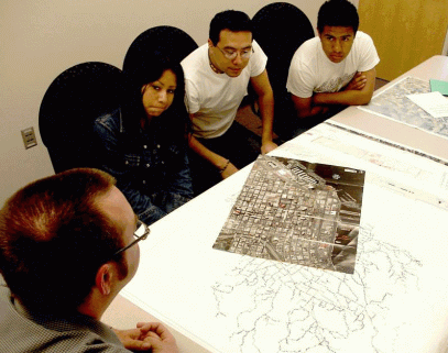
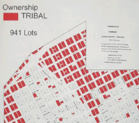
Arizona
|
- Soil Surveys
- Crop Management
- West Nile Virus For State and County Health Programs
- Colorado River Information for the Fish & Wildlife
Service
- Colorado River Indian Tribes Leased Farm Land Information
- Colorado River Indian Tribes - Tribal and Private Land
Ownership in Parker County
- Bureau of Indian Affairs Irrigation System
|
|
Georgia
|
- Madison County serving as pilot county for GPS/GIS
- Purchased GPS kit from Iowa State University
- Developing educational plans for Kit Use
- Summer class - GPS Functions & Use
- Map Volunteer Locations
- Self Guided Tour of Madison County
- Turkey Survey for Wildlife Project
|
- GPS/GIS applications in judging events
- Orienteering at camps
- Scavenger hunt using GPS during 4-H Rally
- Career classes related to GPS/GIS applications
- Determine judging event locations based on county's
participation
- Session on GPS/GIS technology at 4-H Tech Team Retreat
|
Idaho
|
- Getting Started
- 10 Delorme GPS/palm units purchased
- GPS training at local school with tech team
- Youth, teachers, and adult volunteers
- Palm basics, navigation, street atlas software
- Idaho State Leaders Forum
- Five youth tech team members
- Workshop on technology in 4-H
- GPS/palm units models
- GPS caching with workshop participants
- 4-H GPS/GIS Project in school
- GPS/GIS teaching unit purchased from Iowa 4-H Program
- 60 mid-high students learned basic map,compass, and GPS
skills
- Will be utilized to teach 4-H youth on tech teams
|
MYCOE (My Community, Our Earth) Project Ideas
- Partner with local, state, and federal agencies to create a
map of businesses along Indian Creek as part of the uncovering project.
- Create a GIS of the Jump Creek Recreation area to show
potential users dangerous areas.
|
Illinois
|
The "untapped" use of technology in our State
- Rural Areas:
- Lack of basic computer skills
- Lack of "In Depth" classes
- Lack of Face to Face teachers
- Urban Areas
- Technology present, but more knowledge needed
- Training needed for technology career
- Lack of after school computer clubs
- The need of youth to youth teaching
|
The future with GIS/GPS
- Linking groups of teens teaching technology to
others
- Training Internet Masters GIS/GPS skills
- Plotting land to identify the territories of endangered
animals and location of endangered plants
- Outreach to veterans and low income housing and teaching
GIS/GPS
- Assist local governments in gathering information for land
use planning
- Assist environmental groups
|
Michigan
|
Exploration Days '03
- Training for 50 Youth
- Providing an Introduction to GPS
- GPS Basics
- Geocaching Activities
Great Lakes Natural Resource Camp
- Creating a Greater Awareness of the Environmental Concerns
for the Great Lakes
- Exploring Web Based Resources
- GPS Skill Development
- Mapping the Camp
- GPS Scavenger Hunt
Wilderness Technology Immersion Camp
- Building on Last Year
- Technology use in the Wilderness
- GPS, PDA's, Digital Cameras
- Developing GIS/GPS Skills
- Geocaching
- GPS Scavenger Hunts
|
Great Lakes
|
Minnesota
|
Starting with the Basics
- Basic GPS Training
- Find Different Points on the State Fairgrounds with GPS
- Find something
- Find some place
- Become familiar with an area
- Set a trail
|
|
Missouri
|
- Working with GIS
- Working with ArcVoyager and Center for Agriculture,
Resource and Environmental Systems
- MYCOE
- 4-H Aerospace Camp
- 2 Sessions on GPS
- Participants in both 2001 & 2002
- Loaner Equipment and Software
- 2 GPS units
- 29 copies of ArcView
|

|
North Carolina
|
Trying to learn as much as we can about GPS
and
GIS programs already in NC
|
|
North Dakota
|
Starting with the Basics
- Learning about GIS & GPS
- Learning how the technology can be use in 4-H Programming
- Wildlife Mapping
- Environmental Education
- Trip Planning
- Search and Rescue
- ...and more
|
Move into GPS
- Using GPS
- Scavenger Hunts
- GPS Challenges & Games
- Geocaching
- IPAQ GPS
|
Oregon
|
4-H Goals
- Teach students GPS-GIS technology
- Teach life and workforce skills
- Establish Innovative Community Partnership
- Real world projects
- Adelante con Tecnologia
- Hispanic families
- Increase access and computer literacy
- 4-H GPS-GIS members will gather data, create maps, and
teach classes
- County Culvert Project and Threatened species
- Students mark and map culverts
- Culverts mapped which are not Fish-Friendly
- Sheriff's Department GIS program
- Real-time vehicle locator
- Plotting 911 calls
- Staffing and routing
|
|
Tennessee
|
Technology Activities
- Tech Camps
- CyberSeniors/�CyberTeens Program
- GPS workshops
- Tech Teams at State 4-H Events
- Community mapping partnership with Tennessee State
University
Intro to GPS Workshops
- 5 GPS units purchased with local grant
- Discussion about uses of GPS
- Treasure Hunt
- Hands on application to practice using GPS
- Teams follow routes to find long lost treasure
- Successful teams keep spoils of treasure hunt
Radar Gun GIS/GPS Application
- Discuss Experimental Design
- Clocked cars with police radar
- Used GIS/GPS to plot location and meta data about the
"speeders"
|
The Tennessee Tourism Mapping and Analysis
Model
- To implement and maintain an interactive partnership
between local and state 4-H community with chambers of commerce, the
state department of tourism, and universities to use tourism as an
rural/urban economic development tool.
- Identification of community resources
- Information is mapped and shareable
- Youth immersed in authentic practice
- Youth empowered with new technology skills and career
opportunities
- Win - Win situation for both youth and community
- Model's Development Steps:
- Mapping of community's resources that can be used by
tourists (4-H Tech Teams).
- Development of Web Pages for community resources
identified (4-H Tech Teams).
- Link developed Web Pages with local Chamber of Commerce
and State Department of Tourist Development (4-H Tech Teams,
Universities).
- Collection and Analysis of Community/Tourism Centered
Economic Data (4-H Tech Teams, Universities).
|
Utah
|
GPS Technology Program
- School Papers and Presentations
- 4-H Demonstrations
- Geocaching
- Outdoor Activities
- Hunting
- Camping
- Fishing
- Riding 4-wheelers
- In June 2003
- 519 4-H Youth Trained
- 2-4 Hours of Instruction
- 2-4 Hours of Practice using GPS
|
|
Washington
|
T.E.C.S - Teens Exploring Computer and Sharing
- Snohomish County
- Working with the county natural resource department to
teach GPS and GIS skills to youth.
- Working with commercial GPS equipment companies to use
rental equipments for free on the weekends
- Put together a GPS and put GIS software on Computer lab
computers
- Lincoln County
- Working with the weed department to use the youths GPS
and GIS knowledge to track weeds
- King County
- Working with the agriculture department to track bugs
|
|
 The
U.S.
Department of Agriculture
maintains the
Cooperative State Research, Education and Extension Services or CSREES.
The CSREES mission is to
"advance knowledge for agriculture, the environment, human health and
well-being,
and communities through national program leadership and federal
assistance."
One of the programs they maintain is the 4-H Youth Technology
Leadership Team Program
that fosters the learning of geographic information systems and the
global
positioning satellite system.
The
U.S.
Department of Agriculture
maintains the
Cooperative State Research, Education and Extension Services or CSREES.
The CSREES mission is to
"advance knowledge for agriculture, the environment, human health and
well-being,
and communities through national program leadership and federal
assistance."
One of the programs they maintain is the 4-H Youth Technology
Leadership Team Program
that fosters the learning of geographic information systems and the
global
positioning satellite system.