Commercial off the shelf Enterprise Resource Planning Systems are designed to provide a variety of tools to perform business analysis.However such systems can not utilize the geographic and geo-historical dimension of the information.In today's integrated global business environment it is imperative that this missing link be automated and integrated to achieve a true ERP environment that does not only help you plan your resources but also support your monitoring processes. Geography matters whether our business line is logistics, utilities, telecommunication, local government, environment, natural resources, health, education or defense.This paper highlights the importance of spatial information and its integration in a Global eBusiness Model and provokes a thinking process of how to integrate Geographic Information Systems with existing ERP, MRP, ESS, MIS, or DSS systems.
Keywords: GIS, eBusiness, SAP, Mapping, ESRI, Internet, Artificial Intelligent.
Introduction
A number of new business models
have emerged since the introduction of the buzz word eBusiness.The scope
of this paper does not cover the specifics of such models, instead it highlights
the ever growing importance and sensitivity of time and geography
in our daily business processes.
A business model is simply the architecture of a company and its network of partners for creating, marketing and delivering value and relationship capital to a global customer's base in order to generate profitable and sustainable revenue streams.In today's volatile economy effective and successful business models are those that are capable of eliminating time and geographic barriers to reach international markets from one's desktop.Global communication and transportation technologies, global culture, global social norms, global knowledge base, and global political stability are the major drivers of a global business environment. An understanding of global expectations, regionalism, nationalism, laws, work hours and language differences are crucial in order to penetrate and compete in global markets, product brands, and operations.
Fool Proof - Artificial Think
Tank!
Integration of such global scenarios
into our strategic and day to day operation level business processes requires
a broader approach to establish a true Enterprise Resource Planning &
Monitoring System - ERPMS.A system that provides a live link between research,
planning, tactical analysis efforts sales and marketing, as well as revenue
streams is vital.A system that helps identify the best possible exploration
site, measure of its resources, assist in transmission and transportation,
provide the best markets and location assessments, and track down revenue
streams through the global distribution network is desirable.Ideally,
the same system should be capable of supporting emergency response operations
and Environmental Impact Assessments (EIA) during a business process.
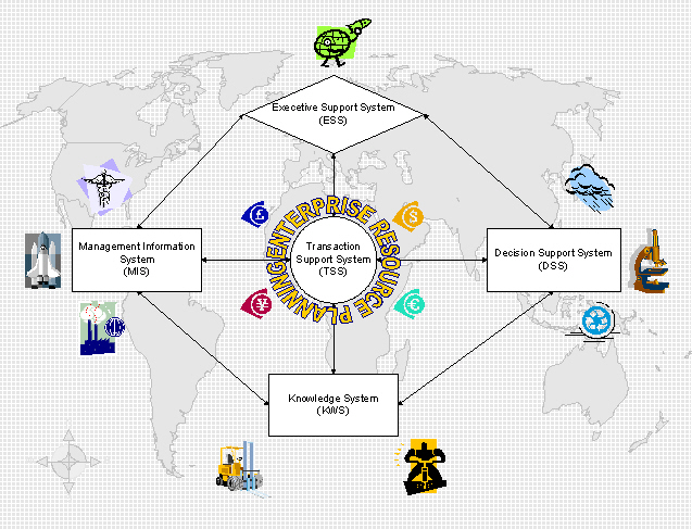
Figure 1
Click for larger image
The theory of such a system is not new.Such intelligence and integration do exist in successful businesses environments; however, a significant part of it remains undocumented and segregated in the brains of capable human resources of an enterprise.We call it loss of skill and experience when someone decides to take up new challenges in another enterprise.In a global eBusiness environment having just one of these links missing can cause a tremendous setback.There is no substitute for human intelligence and creativity and therefore HR will always remain central to a successful business or global eBusiness model. However "the key to success in the twenty first century is doing business at the speed of thought - Bill Gates".The Thought is the outcome of a thinking process and we have no choice but to recognize and appreciate the automation of intelligent business links and embed years of enterprise experience into an artificial intelligent system that supports business thinking processes that will respond to a 21st century market.
The establishment of such systems was neither conceived nor required until recently.Technological developments were not even capable of supporting such integrated and streamlined global business processes.The emphasis in the last century was to create and develop tools to gather information.The challenge in the twenty first century business environment is how effectively and intelligently those information resources can be integrated and utilized.
GIS- The Information Integrator
While accepting the challenge of
the 21st century we are required to establish an appropriate and cost effective
technological framework that is capable of integrating and managing such
business intelligence.There are three basic questions that need to be
answered.One, what kind of system will support the largest number of data
inputs? Data input may be a customer list, market questionnaire, health
and educational statistics, land use and agricultural maps, GPS locations,
remotely sensed environmental impact imageries, aerial photographs of transmission
networks, weather station data, or financial plans and revenue streams.
Second, what system has the capability to intelligently maintain these
databases in an integrated environment? Third, what kind of system will
provide the best possible information security and integration scenarios
in a global eBusiness environment.One thing becomes obvious that such
system should be able to integrate geography into its analysis for enhanced
global decision-making processes.Only SAP/R3, PeopleSoft, SAS, or SPSS
alone cannot fulfill such requirement.Need arises to establish a broader
resource planning infrastructure that can capture and analyze geographic
and geo-historic information resources.
Most of the organizations consider Geographic Information Systems for visualizing and analyzing existing information. This is true and just use of such system, but is not limited to such extent only.The real power of GIS systems is those silent features that manipulate and analyze those data sources that no other systems can process.Some of them are spatial topological constructions, data overlaying, geocoding, and linear referencing capabilities.(A brief description of these terminologies is provided at the end of this paper)
Capabilities to model and analyze
historic plate tectonic (geological) data is integral to oil and gas exploration.
One of many such activities is to determine the extent of oil reservoir
sediment.This requires identifying rocks that were deposited millions
of years ago.Geographic Information Systems utilization of unique data
gathering tools like Global Positioning Systems (GPS) and Remote Sensing
(RS) can be used to effectively and promptly answer such questions.GIS
allows us to take advantage of time as well as plate (geological) data
in our exploration analytical models.A user can also determine the rate
at which oil is extracted from a well and how to increase the ultimate
recovery potential in a reservoir.We can locate, relocate, as well as
overlay wells, faults, and field data with the rest of the geological data
using such systems.While financial and business management data are usually
stored in a centralized architecture, operational data for each well completion
and treatment is not.Automation and standardization of such spatial data
using GIS can provide a solid and sustainable data feed for a company's
existing ERP Systems. 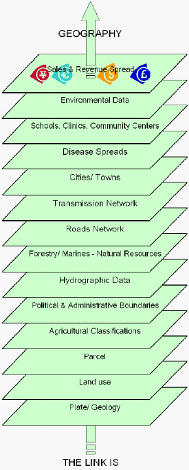
GIS based data integration provides valuable new insight that is invisible and sometime not even possible to generate through traditional spreadsheets and data tables processing alone. Geographic layers are linked and merged with each in a number of ways to achieve certain results; however they may not be captured to address a specific application need.Some of these data sources for example remote sensed data may be used by anyone from health services to weather observers and environmentalists.The common link in overlaying different layers is geography and may not be any other.
Another example of spatial data is a versatile network of pipelines and transportation that is required to transmit oil and gas resources.Transmission and transportation of such fuels is mission critical and an environmentally sensitive process.Day to day operations and management of underground oil and gas storage facilities and thousands of miles of pipeline networks for gathering and distribution of oil and gas resources has a significant impact on its consumers and; without a doubt; global environment.Safety, reliability, capacity and time are the core factors in deploying a successful and sustainable transmission and transportation infrastructure.The fuel that we use in our car or our stoves passes through miles of transmission networks, storage facilities, refineries, ships, trucks and fuel stations before it reaches a car tank. Such complex flows can be effectively and intelligently modeled using GIS tools.Situations like transmission networks breakdown and fuel spills again demand for state of the art GIS based emergency response systems to cost effectively allocate the available rescue resources and contain the problem areas.
GIS based automated business processes can directly integrate with existing company ERP and MRP systems.The most useful information can be the customer street address and inventory location coordinates in such systems.Spatial data with SAP R/3 asset information can be viewed and analyzed directly and efficiently.Problem area reporting and history tracking to work order generation and rectification of the reported problem can be easily managed using GIS and ERP tools.Field crew work progress tracking and scheduling day-to-day business activities can also be significantly enhanced by integrating GIS tools with other resource planning automated systems.
A few more examples of GIS
based business processes automation
Proximity Analysis
Geographic Information Systems are
often used to answer such questions as, how many houses lie within 100
m of this water main?, What is the total number of customers within 10
km of this store? What proportion of a certain crop is within 500 m of
a water resource?

Figure 3
Click for larger image
Geo-statistical Analysis
Socio-economic statistics coupled
with GIS database are used by many organizations for site location analysis,
deploying new marketing strategies and understanding the potential of local
and international customer base.A number of financial institutions have
started looking into integrating GIS tools and processes for enhancing
their financial and marketing strategies.This includes banks, accounting
firm, and government revenue and taxation departments.

Figure 4
Click for larger image
Geographic Links in eBusiness
Composition
Like any other business, an eBusiness
is a composite of customers, products, structure, and revenues.The following
chart briefly illustrates the possible GIS based applications from sales,
support, to risk management and cost benefit analysis.

Figure 5
Click above for larger image
Conclusion & Recommendations
It's a well established fact that
about 80% of the information that we use in our business processes is somewhat
geographic in nature.Whether you are designing a new product or exploiting
new global or local markets, geographic processes are part of the process:
from strategic planning to day-to-day business operations; from a desktop
to a PDA and Cellular Phone, from a car to a truck, vessel and ambulance.
Geography does not only help us find our way home safely, or locate a new
customer but also tracks our money streams securely.Automation and integration
of geographic links can significantly enhance our business responses in
today's ever changing global markets.A live link between GIS technological
infrastructure and ERP and other day-to-day decision support as well as
knowledge systems can prove to be very cost effective from saving lives
and assets to better customer service and marketing.
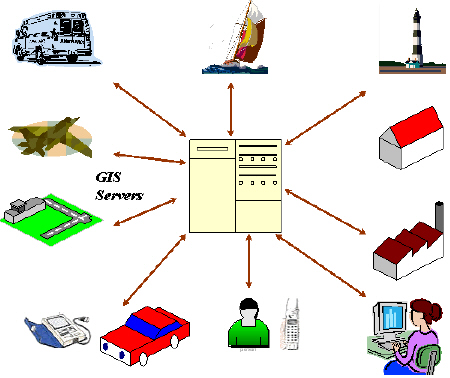
Figure 6
Recommendations
1.Nothing is local anymore -- think globally.Always geo-reference your decision-making processes.
2.If you have an existing GIS infrastructure, you may need to monitor its goals and services more closely.Look for ways and mean to feed your ERP and other support systems with real and near real time, GIS based automated projection models.
3.Depending on the size of your operation and financial resources create an executive level full-time GIS Integration Officer position or establish a part time GIS Steering Committee or both to address the following issues.4.Take a crash course in Geostatistical AnalysisCreatively exploit the need for GIS systems in day-to-day business operations as well as projection and modeling scenarios. Coordinate among all stakeholders to sort out the information dissemination levels and data security and sharing concerns, Standardize and formalize spatial data creation and QA/ QC processes. Develop & document metadata and data dictionary of all enterprise wide data/ information sources. Establish GIS training requirements and opportunities Provide a wide range of backgrounds and viewpoints to make it easier to set budget and resource program priorities. Establish software and hardware and communication infrastructures to disseminate GIS information.
5.Keep the following book on your desk for daily reference.Principles of Geographical Information Systems (Spatial Information Systems and Geo-statistics) by Peter A.Burrough, Rachael McDonnell, Rachel A.McDonnell.OXFORD University Press
Further Readings
Books
- "Geostatistics - Modeling Spatial Uncertainty - Jean-Paul Chilés/ Pierre Delfiner - Wiley Series in Probability and Statistics - Wiley-Interscience, John Wiley & Sons, Inc. Scientific, Technical, and Medical Division 605 Third Avenue, New York, NY 10158-0012
- Why ERP? A Primer on SAP Implementation - F.Robert Jacobs/ D.Clay Whybark - Urban Wemmerlöv, University of Wisconsin - Madison
- Enterprise GIS for Energy Companies - Christian Harder - Environmental Systems Research Institute, Inc.380 New York Street, Redlands, California 92373 - 8100
- ArcView GIS means Business - Christian Harder - Environmental Systems Research Institute, Inc.380 New York Street, Redlands, California 92373 - 8100
- ArcUser - The Magazine for ESRI Software Users - Health Geography, July - September 2002
Papers
- GIS as a foundation for ERP - Engineer Mohammad Issa Baltaji, Chief Planning & Development, Sewerage Directorate, Abu Dhabi Municipality, UAE - Conference Proceedings Page 497 - GIS 2002 International Conference March 11-13, 2002 - Le Royal Meridien, Bahrain
- GIS and Location Services on the Web - Internet Map Server Solutions for Application Providers - An ESRI White Paper - June 2000 - Environmental Systems Research Institute, Inc.380 New York Street, Redlands, California 92373 - 8100
- Utilizing GIS to Protect Lives, Assets and Operations - Mr.Peter R.O'Regan, CASD/ eMap Division, Saudi ARAMCO, KSA - Conference Proceedings Page 551 - GIS 2002 International Conference March 11-13, 2002 - Le Royal Meridien, Bahrain
Websites
- http://www.esri.com
- http://www.inforge.unil.ch/yp
- http://www.accenture.com
- http://www.intergraph.com/gis
- http://www.sdmagazine.com/documents/s=4077/sdm0203a/0203a.htm
Acknowledgement
- Figure 3 & 4 are generated using Microsoft Map Point 2002.Displayed information comes with the COTS product.
References
- Center for eBusiness@MIT
- Wayne Rick, Location, Location, Location - http://www.sdmagazine.com/documents/s=4077/sdm0203a/0203a.htm
- eBusiness Model Design, Classification and Measurements - Magali Dubosson Torbay IUMI/ Alexander Osterwalder, INFORGE/ Yves Pigneur, INFORGE, HEC Lausanne.
- Decision Support for Multimodal Freight Transportation - Dr.John Sutton and Kenneth Bennett, GIS/Trans, Ltd.ArcUser October-December 2001.http://www.gistrans.com
- Geographic Information Officer - A New Executive Position at Many Organization - ArcNews - ESRI Summer 2002 - ESRI International User Conference Issue - Vol.24 No.2
Glossary of used GIS related
terms
Spatial Topology: Spatial Data or Geographic Data Structures that consist of structuring and maintaining line features like road networks, polygon features like district and county boundaries, and Point features like city, hospital and well locations etc.Geo-coding: It is a process that assigns map position to an address record.Following example shows the difference between a non-geo-coded and geo-coded record.
Overlaying: Combining two or more maps that has the same geographic reference is called overlaying. Traditionally overlaying was done by transferring two maps to a clear mylar sheets, and literally overlaying them on a light board.GIS makes this process much more power full by overlay multiple layers of day and integrating it with other related business information.
Linear Reference: Data on utility and transportation networks are kept using a measurement from a fixed reference point along a route.Methods used include mileposts, complete route mileage, geographic coordinates, or GPS coordinates
Dynamic Segmentation: It's a GIS function that locates a point or line segment by interpolating the distance between to known points and allows the recording of information along linear features.
GPS: Global Positioning System
Authors Biography
Bokhari, Mehdi-ul-Hasnain Syed Qadri
is currently working as a consultant with eMap Division of Saudi ARAMCO
in the Kingdom of Saudi Arabia.He has a degree in Computer Sciences as
well as in Geography with over 12 years of international experience in
GIS planning, design, development, and implementation.During these years,
he worked on a range of projects for agriculture, natural resources, forestry,
health, education, transportation, and petroleum sectors.His assignments
involved extensive GIS project planning activities for government agencies,
non-profit organizations, private and public businesses, and multinationals.
Some of his previous were with US Federal Highway Administration, US-Department
of Transportation, Canadian Forest Services, and Canadian Ministry of Environment,
Lands and Parks, United Nations, World Bank, United States Agency for International
Development, Swiss Development Corporation and GTZ (German Aid) and local
health and educational agencies.
Dhahran, Saudi Arabia.
Email: mehdi.bokhari@aramco.co
It is the function of creative men to perceive the relations between thoughts, or things, or forms of expression that may seem utterly different, and to be able to combine them into some new forms_
The power to connect the seemingly unconnected.
William Plomer