Sometimes technology that
originates from within the
government or military has a way of moving down to the private sector.
In order
to see what is coming, we have to look at what these people are using
now.
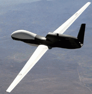
An integrated system that was shown at GEOINT 2004 was the Global Hawk Unmanned Aerial Vehicle (UAV) from Northrop Grumman, and the supporting Global Hawk Ground Segment by Raytheon.
The global Hawk UAV is a high altitude surveillance unmanned aircraft with a range of 12,000 miles and a total in-the-air time of 35 hours. It is flown from a consol and the take off and landing processes are all automated.The Global Hawk is flown by a real pilot, communicates with Air Traffic Control, through controlled airspace, just like a manned airplane.
Click image for larger view.
An integrated system that was shown at GEOINT 2004 was the Global Hawk Unmanned Aerial Vehicle (UAV) from Northrop Grumman, and the supporting Global Hawk Ground Segment by Raytheon.
The global Hawk UAV is a high altitude surveillance unmanned aircraft with a range of 12,000 miles and a total in-the-air time of 35 hours. It is flown from a consol and the take off and landing processes are all automated.The Global Hawk is flown by a real pilot, communicates with Air Traffic Control, through controlled airspace, just like a manned airplane.
The
aircraft itself has several sensor configurations which
include Synthetic Aperture Radar (SAR) with Ground Moving Target
Indicator
(GMTI - one of many military acronyms), Electro Optical, infrared, and
a
traditional visible light image collector.The output of these sensors
is moved
either via wideband line-of-sight digital radio or via satellite data
link.The
mission can be either visible surveillance or it can be configured to
monitor
communication or other electronic signals.
All
of
this data can be moved from the UAV, through the
ground support system and to the intended customer in near real time.
That
means that the information is processed and packaged for delivery
through the
ground support system so it has maximum value to the end user in a very
timely
manner.
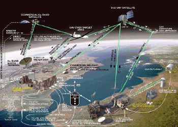
This
image shows how the ground support links the launch and
recovery, the flight path control and the ground processing system
together.

Click image for larger view.
The
logistics of this entire system allow for one real pilot
to control up to three UAVs, the entire ground support can redeployed
in 24
hours, and the whole thing can be moved by three C141 transport planes.
That
also includes all the maintenance equipment and supplies for 30 days of
autonomous operations.
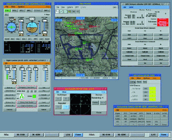
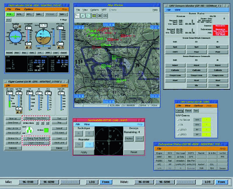
The
control panel
for the pilot below shows the map covering
flight path operations and control, the basic aircraft situations
indicators
(heading, altitude, systems status, etc.) and information on sensor
status.
Click image for larger
view.
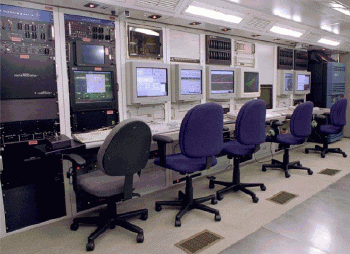
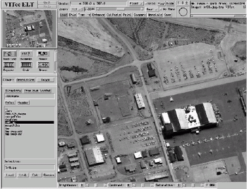
This
is what inside
the ground station looks like.

Click image for larger
view.
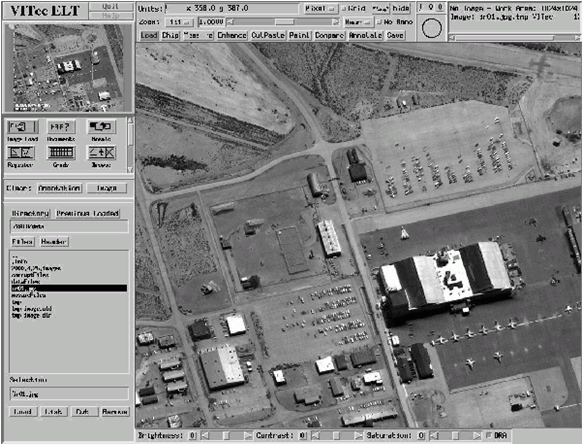
This
last image
shows integration within this system of
standard off-the-shelf software for visualization.
Click image for larger
view.
After
all this data
is collected and processed, it has to be
stored and ultimately de-classified.If the UAV was being used for
homeland security,
it could provide the commercial market with some very high resolution
images in
a number of formats depending on the sensors used.
What
is probably the
most important part of this technology is
that it establishes a process and a set of standard procedures for
unmanned
remote sensing.Not all of this type of collection needs to involve
high
altitude stealth technology UAVs, satellite data links and major
collections of
technology.
For
example, at Bridgewater State College, near Boston, the
GIS department is experimenting with model airplanes, digital cameras
and
simple data links to capture imagery over areas that may include
wetlands, new
real estate developments and other areas of local interest.The cost is
far
cheaper than flying the subject area using commercial aerial
photography, and
the end results can be in near real time.
The
payoff is that the data may be available at a reasonable
cost, the process for collections could become available to commercial
users,
and like many technologies, it may herald a standard method of imagery
collection.
It
is
also quite possible that these systems will be
available on the military surplus market in a few years when we have
moved to
even more advanced technology.Is it conceivable that a company could
buy
several of these systems, and in a nomadic pattern touring the country,
create
current imagery for various local government entities? If you imagine
that the
level of automation includes automatic ortho-rectification of the
imagery, far
better than sub-meter resolution and the fast creation of useable
multi-spectral products (remember near-real time?), this could make
imagery the
commodity we all have wished it could be.
If
you are an
instrument-rated, private pilot with a few
bucks, it might be wise to begin revisiting the Army surplus store and
thinking
about becoming an entrepreneur...
From Our Homepage
Saying Farewell to an Amazing Journey
Communicating with Maps
Is There a GIS Career Ladder?
What does it mean to be geospatially smart? Series
Ways Real Estate and Property Developers Utilize Melissa GeoData for Data-Driven Decisions
Unlocking Value From Daily Satellite Imagery and Insights
Maximizing the Value of Your Address Data with Geo Addressing
How Indoor Mapping Enhances the Security of Smart Buildings
Look Ahead: AI, Location Intelligence and Efficiency
Collaboration Takes on Sea Level Rise & Dynamic Technology Environments
Brownies for Brownfields
Has Everything Been Mapped Already?
How Is Data Literacy Changing in an Artificial Intelligence Landscape
Portfolios for GIS Professionals: More Than Just Maps
How to Create a Distance Matrix in QGIS - A Step-by-Step Guide
7 Ideas for Bringing GIS into the K-12 Classroom
The Geography of Movement