The healthcare management groups that manage U.S.
hospitals and other critical care facilities need to build command
centers equipped with the same geospatial technology used by government
first-responders in order for them to quickly respond to emergency
situations.When one service-based system breaks down, it's an
inconvenience, but when all of the highly engineered services we depend
on break down, the seriousness of the situation changes drastically.
This became evident during Hurricane Katrina.If hospitals and critical
care facilities are to respond to an event within the vital 48-hour
timeframe, they will need near real-time event data to do so.In this
article, we propose how geospatial technologies might effectively be
used to help.
Currently, the vast majority of emergency response technology dollars are spent on systems used by government agencies.This has created a situation where managers of critical care facilities have to wait to be apprised of their situation and then rescued.As we have witnessed first hand, this is no longer good enough.Healthcare decision makers at all hospitals and critical care facilities throughout the United States must use the same systems used by government first-responders.
The response to Hurricane Katrina's impact on New Orleans' healthcare infrastructure started like most emergency events where emergency first-responders at federal, state local agencies did a lot of situation assessment and rescue planning using geospatial technologies before springing into action.However, the heavy reliance on information and rescue direction provided from others came late, putting healthcare staff and patients at risk.In the case of the 317-bed Memorial Medical Center in New Orleans, the facility, owned by Tenet Healthcare Corporation, Dallas, Texas, took a severe hit.During this ordeal, there were more than 2,000 people (260 patients but also staff members and their families and other community members) in the hospital complex.From a statement released by Tenet on Tuesday, Sept.13: "The hospital was surrounded by water as a result of the hurricane and levee breach.Land evacuation was impossible throughout the ordeal."
The flooding all but rendered the hospital's transportation component of its evacuation plan useless.This resulted in a situation where hospital staff had to rely almost exclusively on government first-responders for information about the extent of flooding in the area, and direction on how to proceed; but not within the critical 48-hour window.The same statement cited above goes on to say, "By Sept.2, we were able to evacuate every living patient from the hospital, often using private helicopters hired by Tenet after government rescue efforts were overwhelmed."
During this crisis, Memorial Medical Center and other publicly and privately owned hospitals could have acted more quickly in their own behalf had they been less reliant on government first-responders.The speed of a response to this situation and others like it depends a lot on how quickly event data can be integrated with existing systems, and flow into the decision making process.
One particular technology application, usually considered a critical application by many in the emergency response business, was quickly rendered useless once the City of New Orleans and its environs flooded. Routing applications are the backbone of any emergency management response.But unless they contain current event information, for example, information on flooded streets, the logistics of routing emergency vehicles becomes a blind operation.What is needed is a way to enhance routing applications with the capability of integrating, in near real-time, event information to perform accurate routing.The only way to quickly collect and integrate event data is by using remote sensing technology, GIS and geoprocessing to perform the necessary data integration.(For the purposes of this article, we are defining geoprocessing as the ability to overlay totally unrelated layers of information and to transfer one layer of information to another producing a derivative layer of information containing attributes from both.Extracting a floodwater polygon from satellite imagery and overlaying it onto the street network is such an example.)
Remote Sensing
Satellite imagery, prior to and during the Hurricane Katrina disaster, has become a mainstay technology for both government and its citizenry. Hardly a day goes by without seeing this useful technology on the evening news or on the Internet.A wealth of accessible information is now available to the average person.However, even with this increased awareness, the question arises, "Are these technologies being used by the right users, when they are most needed and in the most useful ways?"
In light of the many emergency response problems hospitals and other critical care facilities in New Orleans faced, perhaps it's time for healthcare administrators and healthcare group leaders to use the same GIS, remote sensing and geoprocessing capabilities used by government first-responders.By adopting this philosophy, healthcare administrators can be more proactive in assessing their own situation during an event, be better prepared to help government first-responders by passing on better information to them about their situation and, be better prepared to initiate their evacuation routing operations within the critical 48-hour timeframe.
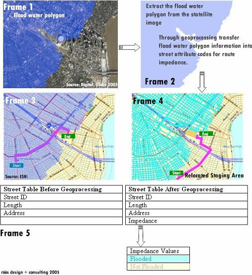
Let's take a look at how an enhanced GIS routing application, updated with event (flooded street) data might be used during a flood event. GIS-based routing applications are designed to generate a route based on stored information about each street segment in the application's street network file.Table items containing descriptive street information, including: street segment name, segment length, bi-directional street address information, street direction, impedance values, turn restrictions, jurisdiction boundaries and many other descriptors are used by a program to generate a route (the actual descriptive content is based on content provided by vendors who specialize in this area).In this scenario, the routing system is presumed to be no longer useful because of street closures due to flooding.Just when this type of information is most critical it no longer works because it lacks event data about which streets are flooded (Frame 3) and could erroneously route you down a flooded street.
Correcting this situation will require the street network files to be updated by the application on the fly, as quickly as satellite imagery can be collected and integrated.Street network files will need to evolve with the times and become read-writable media.They can then be updated with information pertinent to the situation, allowing new information to be coded; street attribute tables can report a street's status as 'flooded' or 'not flooded.' In addition, if the system includes an elevation surface, depth of water could be determined, and from there, the system could also store information on the type of vehicle to be used based upon its ability to function in water of a given depth.A new route can now include streets with some standing water.Knowing the depth of water would allow for more specialized routing applications where rescue vehicles able to function in water of a given depth are being used.
The satellite imagery that was so extensively used during Hurricane Katrina response could provide the answers we're looking for by doing double duty a) as our primary source of information for defining floodwater's extent through a simple a visual examination of the imagery; and b) by capturing and transferring information into codes needed for the updated street network, so that floodwater status for each and every road segment in New Orleans proper (Frame 4) could be known.This requires integrating two very different data types, raster-based satellite imagery and vector-based street data.That's the sort of integration geoprocessing allows.
Geoprocessing
Most GIS professionals agree that GIS is much more then a map-making tool.In fact, through its geoprocessing capabilities, GIS becomes an analytical engine that can drive the decision-making process.As mentioned above, geoprocessing allows operations like taking a floodwater polygon and overlaying it on a street network.
The flood extent information is integrated with the street network.It can be added as a routing impedance code, telling the routing application whether a street is navigable based on it code value (Frame 5).In this example the routing application using the 'Street Table Before Geoprocessing' scenario places no restrictions on routing, while the 'Street Table After Geoprocessing' scenario contains a new field called 'Impedance' as a result of the overlay geoprocessing operation. Frame 4 shows that the routing application can now take the flooding status of a street into consideration.
Hospitals as First-Responders
Healthcare groups need to consider having command centers with these kinds of capabilities to monitor the well being of their member organizations during emergencies.It's ultimately the decision-making process that determines an outcome; more informed decisions, based on real-time event information should, in theory, produce more favorable outcomes.
Making the decision of whether to stay or leave a facility during a crisis needs to be made quickly, but solely relying on others for an assessment of the situation may not produce the outcome most healthcare managers hope to achieve.Instinctively, this decision becomes one of evacuation and routing; using its own vehicles or those supplied by its contractor.Either way, the decision to evacuate requires having knowledge about the extent of street flooding and other system failures.
By law, a hospital's evacuation plan is required to have the necessary contracts in place for transportation services during an emergency. Staging this type of operation during a crisis requires having in hand the very best information available.With power outages and communication channel breakdowns compounding the situation, healthcare facilities need to initiate their own evacuation plan.
In the case of the many healthcare facilities impacted in New Orleans, patients suffered needlessly because evacuation plans became moot when unanticipated flooding become so severe.A hospital information system augmented with enhanced emergency routing is one of many tools that could significantly change the outcome of a disaster response.In the hands of a healthcare group, a professionally designed and managed GIS-based decision support system with enhanced routing is able to both assess their own situation and assist first-responders.
Summary
Both the geospatial and healthcare communities need to recognize the importance of using existing software tools and existing data in new ways to solve problems and better predict outcomes.As the healthcare and geospatial communities experience, and better understand, the different logistical problems that can arise during an emergency response, we can better collaborate to creatively solve problems.The healthcare industry needs to consider embracing the same technologies that are used at all levels of government to build their own command centers.The authors of this article believe they need to make a commitment to be proactive in training future healthcare workers to plan for emergency responses using geospatial technology.
Currently, the vast majority of emergency response technology dollars are spent on systems used by government agencies.This has created a situation where managers of critical care facilities have to wait to be apprised of their situation and then rescued.As we have witnessed first hand, this is no longer good enough.Healthcare decision makers at all hospitals and critical care facilities throughout the United States must use the same systems used by government first-responders.
The response to Hurricane Katrina's impact on New Orleans' healthcare infrastructure started like most emergency events where emergency first-responders at federal, state local agencies did a lot of situation assessment and rescue planning using geospatial technologies before springing into action.However, the heavy reliance on information and rescue direction provided from others came late, putting healthcare staff and patients at risk.In the case of the 317-bed Memorial Medical Center in New Orleans, the facility, owned by Tenet Healthcare Corporation, Dallas, Texas, took a severe hit.During this ordeal, there were more than 2,000 people (260 patients but also staff members and their families and other community members) in the hospital complex.From a statement released by Tenet on Tuesday, Sept.13: "The hospital was surrounded by water as a result of the hurricane and levee breach.Land evacuation was impossible throughout the ordeal."
The flooding all but rendered the hospital's transportation component of its evacuation plan useless.This resulted in a situation where hospital staff had to rely almost exclusively on government first-responders for information about the extent of flooding in the area, and direction on how to proceed; but not within the critical 48-hour window.The same statement cited above goes on to say, "By Sept.2, we were able to evacuate every living patient from the hospital, often using private helicopters hired by Tenet after government rescue efforts were overwhelmed."
During this crisis, Memorial Medical Center and other publicly and privately owned hospitals could have acted more quickly in their own behalf had they been less reliant on government first-responders.The speed of a response to this situation and others like it depends a lot on how quickly event data can be integrated with existing systems, and flow into the decision making process.
One particular technology application, usually considered a critical application by many in the emergency response business, was quickly rendered useless once the City of New Orleans and its environs flooded. Routing applications are the backbone of any emergency management response.But unless they contain current event information, for example, information on flooded streets, the logistics of routing emergency vehicles becomes a blind operation.What is needed is a way to enhance routing applications with the capability of integrating, in near real-time, event information to perform accurate routing.The only way to quickly collect and integrate event data is by using remote sensing technology, GIS and geoprocessing to perform the necessary data integration.(For the purposes of this article, we are defining geoprocessing as the ability to overlay totally unrelated layers of information and to transfer one layer of information to another producing a derivative layer of information containing attributes from both.Extracting a floodwater polygon from satellite imagery and overlaying it onto the street network is such an example.)
 |
Remote Sensing
Satellite imagery, prior to and during the Hurricane Katrina disaster, has become a mainstay technology for both government and its citizenry. Hardly a day goes by without seeing this useful technology on the evening news or on the Internet.A wealth of accessible information is now available to the average person.However, even with this increased awareness, the question arises, "Are these technologies being used by the right users, when they are most needed and in the most useful ways?"
In light of the many emergency response problems hospitals and other critical care facilities in New Orleans faced, perhaps it's time for healthcare administrators and healthcare group leaders to use the same GIS, remote sensing and geoprocessing capabilities used by government first-responders.By adopting this philosophy, healthcare administrators can be more proactive in assessing their own situation during an event, be better prepared to help government first-responders by passing on better information to them about their situation and, be better prepared to initiate their evacuation routing operations within the critical 48-hour timeframe.
Let's take a look at how an enhanced GIS routing application, updated with event (flooded street) data might be used during a flood event. GIS-based routing applications are designed to generate a route based on stored information about each street segment in the application's street network file.Table items containing descriptive street information, including: street segment name, segment length, bi-directional street address information, street direction, impedance values, turn restrictions, jurisdiction boundaries and many other descriptors are used by a program to generate a route (the actual descriptive content is based on content provided by vendors who specialize in this area).In this scenario, the routing system is presumed to be no longer useful because of street closures due to flooding.Just when this type of information is most critical it no longer works because it lacks event data about which streets are flooded (Frame 3) and could erroneously route you down a flooded street.
Correcting this situation will require the street network files to be updated by the application on the fly, as quickly as satellite imagery can be collected and integrated.Street network files will need to evolve with the times and become read-writable media.They can then be updated with information pertinent to the situation, allowing new information to be coded; street attribute tables can report a street's status as 'flooded' or 'not flooded.' In addition, if the system includes an elevation surface, depth of water could be determined, and from there, the system could also store information on the type of vehicle to be used based upon its ability to function in water of a given depth.A new route can now include streets with some standing water.Knowing the depth of water would allow for more specialized routing applications where rescue vehicles able to function in water of a given depth are being used.
The satellite imagery that was so extensively used during Hurricane Katrina response could provide the answers we're looking for by doing double duty a) as our primary source of information for defining floodwater's extent through a simple a visual examination of the imagery; and b) by capturing and transferring information into codes needed for the updated street network, so that floodwater status for each and every road segment in New Orleans proper (Frame 4) could be known.This requires integrating two very different data types, raster-based satellite imagery and vector-based street data.That's the sort of integration geoprocessing allows.
Geoprocessing
Most GIS professionals agree that GIS is much more then a map-making tool.In fact, through its geoprocessing capabilities, GIS becomes an analytical engine that can drive the decision-making process.As mentioned above, geoprocessing allows operations like taking a floodwater polygon and overlaying it on a street network.
The flood extent information is integrated with the street network.It can be added as a routing impedance code, telling the routing application whether a street is navigable based on it code value (Frame 5).In this example the routing application using the 'Street Table Before Geoprocessing' scenario places no restrictions on routing, while the 'Street Table After Geoprocessing' scenario contains a new field called 'Impedance' as a result of the overlay geoprocessing operation. Frame 4 shows that the routing application can now take the flooding status of a street into consideration.
Hospitals as First-Responders
Healthcare groups need to consider having command centers with these kinds of capabilities to monitor the well being of their member organizations during emergencies.It's ultimately the decision-making process that determines an outcome; more informed decisions, based on real-time event information should, in theory, produce more favorable outcomes.
Making the decision of whether to stay or leave a facility during a crisis needs to be made quickly, but solely relying on others for an assessment of the situation may not produce the outcome most healthcare managers hope to achieve.Instinctively, this decision becomes one of evacuation and routing; using its own vehicles or those supplied by its contractor.Either way, the decision to evacuate requires having knowledge about the extent of street flooding and other system failures.
By law, a hospital's evacuation plan is required to have the necessary contracts in place for transportation services during an emergency. Staging this type of operation during a crisis requires having in hand the very best information available.With power outages and communication channel breakdowns compounding the situation, healthcare facilities need to initiate their own evacuation plan.
In the case of the many healthcare facilities impacted in New Orleans, patients suffered needlessly because evacuation plans became moot when unanticipated flooding become so severe.A hospital information system augmented with enhanced emergency routing is one of many tools that could significantly change the outcome of a disaster response.In the hands of a healthcare group, a professionally designed and managed GIS-based decision support system with enhanced routing is able to both assess their own situation and assist first-responders.
Summary
Both the geospatial and healthcare communities need to recognize the importance of using existing software tools and existing data in new ways to solve problems and better predict outcomes.As the healthcare and geospatial communities experience, and better understand, the different logistical problems that can arise during an emergency response, we can better collaborate to creatively solve problems.The healthcare industry needs to consider embracing the same technologies that are used at all levels of government to build their own command centers.The authors of this article believe they need to make a commitment to be proactive in training future healthcare workers to plan for emergency responses using geospatial technology.
From Our Homepage
Saying Farewell to an Amazing Journey
Communicating with Maps
Is There a GIS Career Ladder?
What does it mean to be geospatially smart? Series
Ways Real Estate and Property Developers Utilize Melissa GeoData for Data-Driven Decisions
Unlocking Value From Daily Satellite Imagery and Insights
Maximizing the Value of Your Address Data with Geo Addressing
How Indoor Mapping Enhances the Security of Smart Buildings
Look Ahead: AI, Location Intelligence and Efficiency
Collaboration Takes on Sea Level Rise & Dynamic Technology Environments
Brownies for Brownfields
Has Everything Been Mapped Already?
How Is Data Literacy Changing in an Artificial Intelligence Landscape
Portfolios for GIS Professionals: More Than Just Maps
How to Create a Distance Matrix in QGIS - A Step-by-Step Guide
7 Ideas for Bringing GIS into the K-12 Classroom
The Geography of Movement