Geospatial data are only as useful as they are
accessible. The people who require urgent access to geospatial data -
such as emergency response managers, military personnel, safety
managers, utility engineers and municipal workers - typically need them
in a format that can be shared, analyzed and commented on via wireless
laptops.
For the groups highlighted above, as well as for researchers, building professionals and others, the ability to reliably communicate geospatial information is mission-critical. Data need to be instantly available to project team members, whether they are assembled on-site or working individually at remote locations. The aim is to not only distribute data but also share comments and provide people with greater flexibility in viewing and exploring geospatial data.
In the past, complex geospatial mapping data were distributed with multiple layers on paper. More recently digital maps have become common, but the large file sizes can make them difficult to send and view - let alone to annotate and share.
For instance, GeoTIFF files can be large - 100MB or more - making them challenging to send over network connections serving remote locations or areas impacted by disasters. As a workaround, team members might send "flattened" maps with information layers - highlighted data for sewers, city utilities and electrical grids - overlaid on the street map of an area. But trying to decipher information in this tangle of lines is slow, error-prone work.
Another tactic to support widespread distribution of maps is to distill them to JPEG files. Unfortunately, the resulting files can be less than ideal for professionals in the field because data are lost in translation, the maps can’t be scaled, and they are often too pixilated. For geospatial data to be useful and accessible digitally, they have to be small enough to distribute readily, be easily available to diverse audiences using an array of computing devices, ensure data integrity, and support commenting and collaboration.
Enhanced support for digital delivery of geospatial data
The latest release of Adobe Acrobat and the free, ubiquitous Adobe Reader software offer features that bring capabilities and control to sharing geospatial data digitally. The platform- and application-independent Portable Document Format (PDF) files created in Acrobat 9 Pro Extended can reach people anywhere at any time with rich, interactive geospatial data.
PDF helps address the challenge of dealing with the large size of geospatial data by compressing data dramatically. A TIFF file, after georegistration and conversion to PDF, can be as much as 80 percent smaller - a more manageable size for most networks and machines. The smaller files are readily available to people using Adobe Reader. This means that people don’t have to download more software to work with geospatial files. Instead, they can use the client software to interact with maps, measure distances and turn layers on and off.
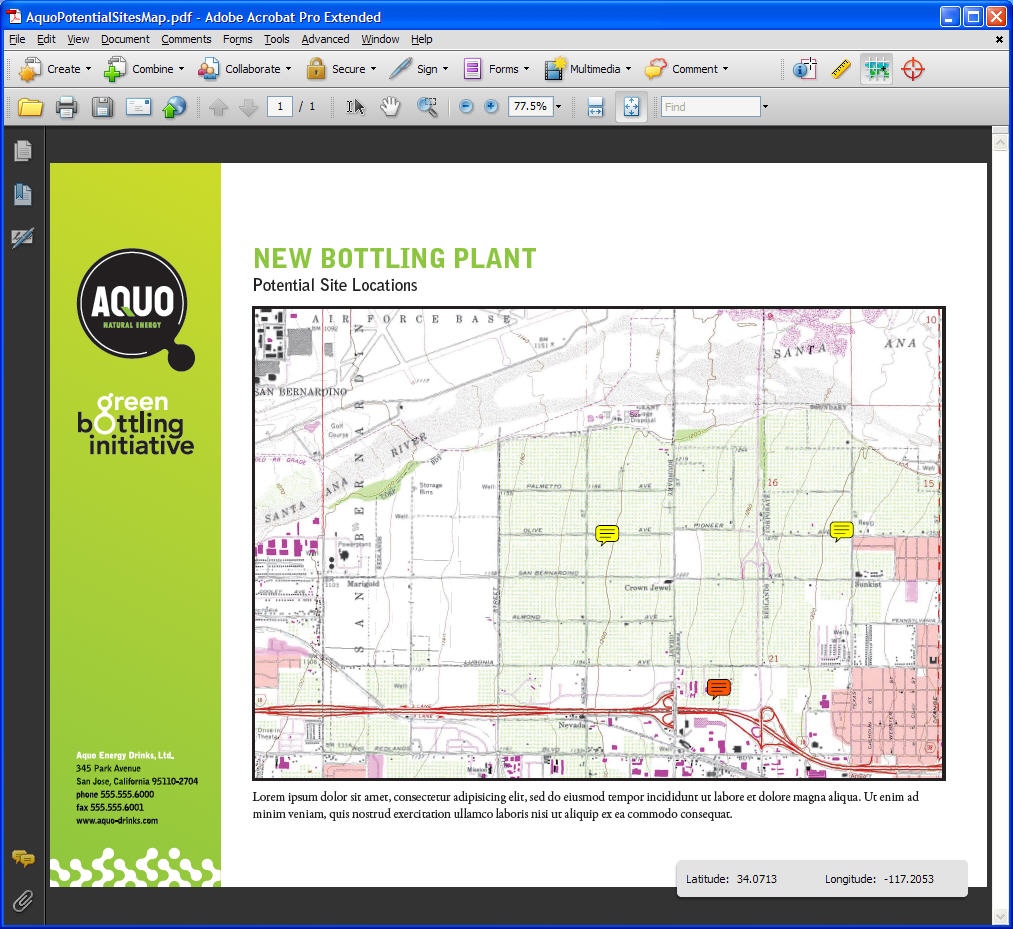
Acrobat 9 also makes it easy to collaborate on content in maps, because it enables reviewers to bring maps into digital review and markup workflows. This saves time because users don’t have to refer to a separate and potentially confusing paper workflow or email conversation. They can comment and review notes within the PDF map file and circulate their annotated versions. In addition, they can include digital maps (along with other content) in a wide range of presentations instead of having to send maps as separate paper copies.
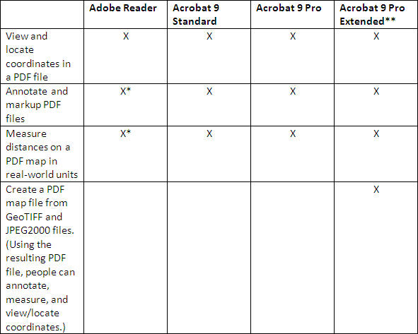
Different Acrobat 9 offerings are available to meet varying customer requirements. The chart below highlights which geospatial features are supported in each version.
* This is possible only with PDF files that are "Reader-enabled." These
are PDF files in which document authors use the full version of Acrobat
software (Acrobat Standard, Acrobat Pro, or Acrobat Pro Extended) to
enable certain capabilities to be available to people using Adobe
Reader.
** Acrobat 9 Pro Extended is available for Microsoft Windows only.
New mapping features in Acrobat 9
New features in Acrobat 9 support several ways of interacting with mapping and geospatial data.
Geospatial location
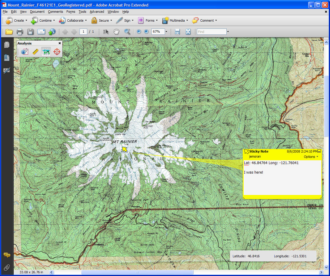
Users can view coordinates on Windows and Macintosh computers. When they open a PDF file that has coordinate information, Adobe Reader offers a geospatial location tool in the analysis tool bar, enabling them to see where they are, based on their coordinates. Coordinates may be found in two ways. First, with the Geospatial Location tool, a user can hover the mouse over the map area and coordinates will display in a widget at the bottom of the application window. Another option is to enter latitude and longitude coordinates and use Adobe Reader (or the full version of Acrobat) to locate the spot for you.
Users can also measure distances in PDF files, when enabled to do so by
the author of the file using Acrobat 9 Pro Extended. In
"Reader-enabled" files - PDF documents in which authors using Acrobat
enable certain capabilities to be available to people using Adobe
Reader - recipients can use Adobe Reader to mark up maps and have the
comment reference the coordinates. By viewing PDF files with Acrobat 9
or Adobe Reader, users can see traditional longitude and latitude
coordinates in decimal or degree minutes seconds (DMS) format.
Measurement
Acrobat 9 Pro Extended can be used to create PDF files with geospatially aware data. Users can measure the distance between points using a variety of units, such as miles or millimeters, and make routes by combining points together. The measurement is added to the PDF as an annotation layer. Unlike JPEG or TIFF, when a user zooms in or out on a file, the scale for measurement is adjusted automatically.
Geospatial authoring
Geospatial authoring capabilities in Acrobat 9 Pro Extended enable users to open and save as a PDF any GeoTIFF file or JPEG 2000 file that has coordinate information embedded in it. Additionally map owners can import SHP files into a PDF map file; they are then retained as layers in the PDF file. Viewers can then turn these layers in the PDF file on and off to show the layers most relevant to them.
Geospatial registration
If users have a map without geospatial information, but know some of the coordinates on it, they can georegister it to fill in missing information and ensure accuracy. If users know the projection used to create the map in question, they can use the geospatial registration wizard on the analysis toolbar and get the other coordinates.
The right geospatial data in the right place
By enabling people to create and distribute geospatial data in compact, layered, readily accessible PDF files, Acrobat 9 Pro Extended allows organizations to deliver data where they are needed without jeopardizing quality or usefulness. At the same time, the ability to use Adobe Reader to comment on geospatial data in PDF improves communication and collaboration across project teams.
This accurate communication of geospatial data is critical - both to support the infrastructure of people’s daily lives, and in times of emergency. So, for example, in a building project, all team members can be "on the same page" about the city infrastructure that would support the finished building, and about any constraints on the site, in order to complete the project as time- and cost-effectively as possible.
In an emergency, such as a flood, responders can scan paper maps, put them in compact PDF files, and share them widely across wireless networks to coordinate distribution of reliable, actionable data in the affected areas. Responders can immediately notify others of any problems, communicate precisely where those problems are, and be alert for potentially hazardous infrastructure, such as power lines and generators.
Both office-based project teams facing tight deadlines and emergency responders working long hours in difficult conditions appreciate the same benefit of delivering geospatial data in PDF: With its intuitive markups and layers, PDF makes complex geospatial data readily accessible and easy to interact with and understand.
For the groups highlighted above, as well as for researchers, building professionals and others, the ability to reliably communicate geospatial information is mission-critical. Data need to be instantly available to project team members, whether they are assembled on-site or working individually at remote locations. The aim is to not only distribute data but also share comments and provide people with greater flexibility in viewing and exploring geospatial data.
In the past, complex geospatial mapping data were distributed with multiple layers on paper. More recently digital maps have become common, but the large file sizes can make them difficult to send and view - let alone to annotate and share.
For instance, GeoTIFF files can be large - 100MB or more - making them challenging to send over network connections serving remote locations or areas impacted by disasters. As a workaround, team members might send "flattened" maps with information layers - highlighted data for sewers, city utilities and electrical grids - overlaid on the street map of an area. But trying to decipher information in this tangle of lines is slow, error-prone work.
Another tactic to support widespread distribution of maps is to distill them to JPEG files. Unfortunately, the resulting files can be less than ideal for professionals in the field because data are lost in translation, the maps can’t be scaled, and they are often too pixilated. For geospatial data to be useful and accessible digitally, they have to be small enough to distribute readily, be easily available to diverse audiences using an array of computing devices, ensure data integrity, and support commenting and collaboration.
Enhanced support for digital delivery of geospatial data
The latest release of Adobe Acrobat and the free, ubiquitous Adobe Reader software offer features that bring capabilities and control to sharing geospatial data digitally. The platform- and application-independent Portable Document Format (PDF) files created in Acrobat 9 Pro Extended can reach people anywhere at any time with rich, interactive geospatial data.
PDF helps address the challenge of dealing with the large size of geospatial data by compressing data dramatically. A TIFF file, after georegistration and conversion to PDF, can be as much as 80 percent smaller - a more manageable size for most networks and machines. The smaller files are readily available to people using Adobe Reader. This means that people don’t have to download more software to work with geospatial files. Instead, they can use the client software to interact with maps, measure distances and turn layers on and off.
Acrobat 9 also makes it easy to collaborate on content in maps, because it enables reviewers to bring maps into digital review and markup workflows. This saves time because users don’t have to refer to a separate and potentially confusing paper workflow or email conversation. They can comment and review notes within the PDF map file and circulate their annotated versions. In addition, they can include digital maps (along with other content) in a wide range of presentations instead of having to send maps as separate paper copies.
Different Acrobat 9 offerings are available to meet varying customer requirements. The chart below highlights which geospatial features are supported in each version.
 |
** Acrobat 9 Pro Extended is available for Microsoft Windows only.
New mapping features in Acrobat 9
New features in Acrobat 9 support several ways of interacting with mapping and geospatial data.
Geospatial location
Users can view coordinates on Windows and Macintosh computers. When they open a PDF file that has coordinate information, Adobe Reader offers a geospatial location tool in the analysis tool bar, enabling them to see where they are, based on their coordinates. Coordinates may be found in two ways. First, with the Geospatial Location tool, a user can hover the mouse over the map area and coordinates will display in a widget at the bottom of the application window. Another option is to enter latitude and longitude coordinates and use Adobe Reader (or the full version of Acrobat) to locate the spot for you.
 |
 |
Measurement
Acrobat 9 Pro Extended can be used to create PDF files with geospatially aware data. Users can measure the distance between points using a variety of units, such as miles or millimeters, and make routes by combining points together. The measurement is added to the PDF as an annotation layer. Unlike JPEG or TIFF, when a user zooms in or out on a file, the scale for measurement is adjusted automatically.
Geospatial authoring
Geospatial authoring capabilities in Acrobat 9 Pro Extended enable users to open and save as a PDF any GeoTIFF file or JPEG 2000 file that has coordinate information embedded in it. Additionally map owners can import SHP files into a PDF map file; they are then retained as layers in the PDF file. Viewers can then turn these layers in the PDF file on and off to show the layers most relevant to them.
Geospatial registration
If users have a map without geospatial information, but know some of the coordinates on it, they can georegister it to fill in missing information and ensure accuracy. If users know the projection used to create the map in question, they can use the geospatial registration wizard on the analysis toolbar and get the other coordinates.
The right geospatial data in the right place
By enabling people to create and distribute geospatial data in compact, layered, readily accessible PDF files, Acrobat 9 Pro Extended allows organizations to deliver data where they are needed without jeopardizing quality or usefulness. At the same time, the ability to use Adobe Reader to comment on geospatial data in PDF improves communication and collaboration across project teams.
This accurate communication of geospatial data is critical - both to support the infrastructure of people’s daily lives, and in times of emergency. So, for example, in a building project, all team members can be "on the same page" about the city infrastructure that would support the finished building, and about any constraints on the site, in order to complete the project as time- and cost-effectively as possible.
In an emergency, such as a flood, responders can scan paper maps, put them in compact PDF files, and share them widely across wireless networks to coordinate distribution of reliable, actionable data in the affected areas. Responders can immediately notify others of any problems, communicate precisely where those problems are, and be alert for potentially hazardous infrastructure, such as power lines and generators.
Both office-based project teams facing tight deadlines and emergency responders working long hours in difficult conditions appreciate the same benefit of delivering geospatial data in PDF: With its intuitive markups and layers, PDF makes complex geospatial data readily accessible and easy to interact with and understand.
From Our Homepage
Saying Farewell to an Amazing Journey
Communicating with Maps
Is There a GIS Career Ladder?
What does it mean to be geospatially smart? Series
Ways Real Estate and Property Developers Utilize Melissa GeoData for Data-Driven Decisions
Unlocking Value From Daily Satellite Imagery and Insights
Maximizing the Value of Your Address Data with Geo Addressing
How Indoor Mapping Enhances the Security of Smart Buildings
Look Ahead: AI, Location Intelligence and Efficiency
Collaboration Takes on Sea Level Rise & Dynamic Technology Environments
Brownies for Brownfields
Has Everything Been Mapped Already?
How Is Data Literacy Changing in an Artificial Intelligence Landscape
Portfolios for GIS Professionals: More Than Just Maps
How to Create a Distance Matrix in QGIS - A Step-by-Step Guide
7 Ideas for Bringing GIS into the K-12 Classroom
The Geography of Movement