In the movement toward digital imaging, the market started with spaceborne sensors (satellites).When satellites were launched into space, engineers realized they needed to offer a digital platform to exploit satellites to their fullest potential.Initially the first spaceborne sensors scanned the earth's surface by pushing a line of sensors over its surface.This began the movement towards using digital technology for mapping purposes.
Although spaceborne sensors provided the first leap towards digital imagery acquisition, they have several limitations.They are on a set orbit time of about 90 minutes, which makes them slow to acquire imagery of large areas.They are heavily dependent on the earth's weather conditions, such as cloud coverage at the time of image acquisition, meaning they are not flexible to users' needs.They are also very expensive to maintain and their services cannot be afforded by many organizations.Thus, spaceborne sensors were followed by airborne imaging sensors, which are mounted onto aircraft and flown over areas to acquire imagery.Also based on line sensor technology, these sensors are easier to operate and manipulate for various project needs.Presently, three-line sensors appear to be the preferred sensors in the market.They are very appealing to users because they are the equivalent of having three cameras in one sensor: one for panchromatic imagery, one for color imagery and one for false color infrared image acquisition. These sensors are also flexible enough to cover users' needs quickly and have a high price-to-performance ratio.
For starters, airborne sensors are now delivering results that spaceborne sensors promised but had much difficulty delivering:
- a seamless, large area coverage,
- imagery taken in a timely manner without long intervals between acquisitions, and
- low product price
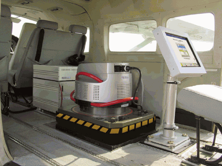
Figure 1: ADS40_inplane2: Airborne digital sensors are not
as dependent on weather conditions as satellites.They are mounted on aircraft
and flown over the earth's surface to capture imagery.(ADS40_inplace2
image courtesy of Leica Geosystems GIS & Mapping, LLC)
Secondly, the automated nature of an airborne sensor's digital workflow makes project completion a much smoother process for users, from data acquisition to updating a GIS.The absence of film labs and film scanning eliminate tedious, costly and time-consuming steps, signifying significant time and cost savings to users in the long run.Additionally, a complete workflow from project planning through flight management, data download, processing and integration into a GIS is a must for users as they strive for workflow automation.Market leaders realize this and they are making modules at all phases of imaging workflow, from data acquisition to updating a GIS, available from one supplier.Sensors currently available on the market, such as the ADS40 from Leica Geosystems GIS & Mapping (See Figure 1), have made great strides in integrating standard photogrammetric workflow steps.
Airborne sensors are impacting our industry in other ways as well.They require less human interaction when operating, reducing the risk of human error.Airborne sensors have already made improved radiometric quality (See Figure 2) and improved digital surface models a reality. The CCD response in sensors is linear and provides an excellent dynamic range, resulting in much sharper color and more clear detail.Three-line sensors, which capture imagery looking forward, backward and nadir from a plane, provide insight into all parts of an imaged object because all three strips with different view angles provide a 100 percent overlap. The three-line principle results in no dead zones or occluded areas, providing insight to all parts of an imaged object.Additionally, they can cover much larger areas of the earth's surface in record time.For example, the ADS40- a three-line sensor- has already successfully captured data over 90,000 square miles of land in Nebraska in about three weeks.
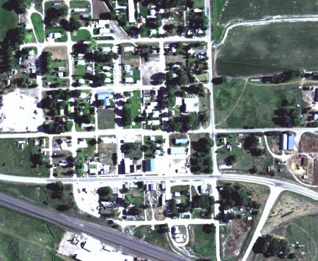
Figure 2: Radiometric: A radiometrically-balanced
aerial photo of a rural area of Nebraska acquired with the ADS40 Airborne
Digital Sensor.Unlike film photography, imagery acquired by such sensors
can be manipulated to fit users' specific needs.(Radiometric image courtesy
of EarthData)
Users must note that the benefits provided by sensors do not mean that a digital workflow is easier to understand than a film-based workflow. As with film, certain project requirements will surely involve redoing certain processes, such as re-flying areas or making adjustments, perhaps in the processing steps, so that results meet clients' needs.What makes the digital workflow more attractive than film is that it is more efficient. Well-trained personnel can keep a digital workflow at a high production rate, resulting in more product delivery coupled with a fast turnaround time.
Currently, Leica Geosystems GIS & Mapping owns the majority of the market share in large-format airborne digital sensors.With about 15 units in operation worldwide, we have a good understanding of trends and needs in the market.Customers are presently using our sensors primarily to obtain digital surface models and true ortho-photos for photogrammetric workflows. While the excellent remote sensing capabilities of airborne sensors are still not being fully exploited by photogrammetric users, I believe they will soon begin to recognize the advantage of sensors' excellent band separation qualities.The future will also bring the integration of different sensors. The ADS40 already combines imaging, positioning and navigation sensors. Combining other types of sensors such as ranging or LIDAR would only enhance this and similar sensors on the market.I see the market further developing this concept soon.
With the advent of digital camera formats, what will become of film? Film is definitely not dead.It won't go away, at least not anytime soon. With development dollars no longer targeting film but towards digital imaging sensors, film has certainly hit its peak.The demand for film deliverables will continue to drop as digital sensor technology improves.However, film applications offer unique factors that are still needed by the market. Film photos are instant shots of the ground's conditions; they cannot be tampered with in any way and will always be an invaluable and authentic record of the earth's surface.However digital sensors' automated workflow, flexibility and high performance-to-price ratio is quickly becoming the preferred method for imagery acquisition.