SRC
190 South Glassell Street, Suite #201
Orange, CA 92866
Phone: (714) 516-2400
Fax: (714) 516-2410
www.extendthereach.com
Introduction
When it comes to data manipulation, most people still use Microsoft Excel. Everybody has it; most people can use it; therefore its limitations may be more readily accepted. SRC has developed a data manipulation product that is more focused on spatial data, large data sets and speed in creating data transforms. It is also a visual workflow tool, allowing the user to create and save processes that will be performed over and over. Alteryx also uses existing tools you may have on your computer, such as geocoding engines, and will create output that is native to most mapping products.
Scope
Alteryx is a visual workflow tool that allows for transformation of large datasets and can process in the range of 20 to 30 million records per hour. It will merge disparate data types (such MapInfo and Shape files), create new data layers and can run as a Web-based application as well as on the desktop. From the toolbox, icons can be linked to assemble processes and functions. The user interface provides the means to view results in both tabular format and as a map, without having to leave Alteryx and load data into another program. Alteryx also works with other SRC products like Allocate.
The User Interface
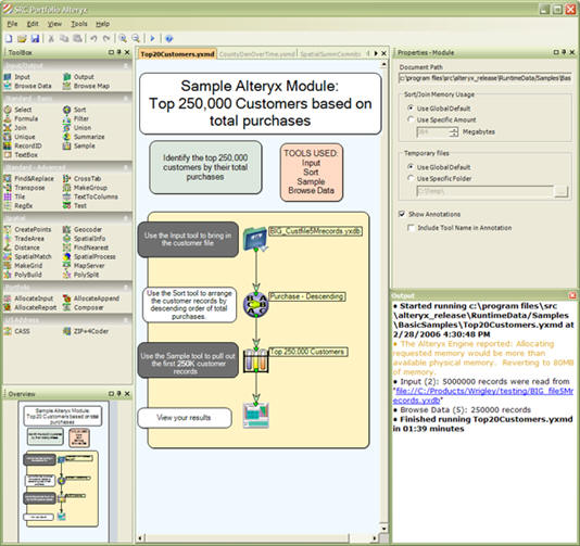
Below is an example of the user interface and how processes can be linked by icons. In this graphic, the left-hand side has the toolbox. The center window shows the process flow with annotations. On the right side are the selected properties (maps and data can also be browsed here). In the lower right are the process steps and the elapsed time. A nice touch is the process overview window in the lower left where longer and more complicated processes can be seen.
 |
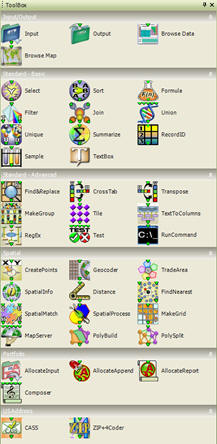
The Toolbox
The toolbox, shown below, shows the functions and processes that can be linked together to form a workflow. Both the function and the look of the icons can be customized by the user.
 |
A More Complicated Workflow
Below is an example of a telecommunications workflow. Note how the process is annotated, the linkages defined and the workflow divided into sections. These workflows can be re-used as well, by swapping out file inputs. At the bottom of the graphic is the output window showing the processes and the total run-time.
 |
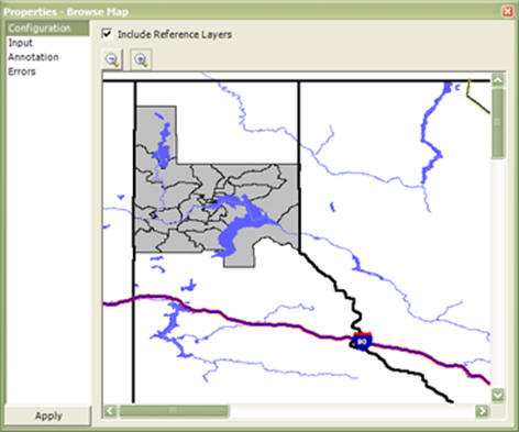
Mapping the results
The Properties Window displays a map of the process results.
 |
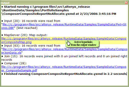
The output window displays hyperlinks of data and result locations. This allows the user to navigate directly from the output window to the data.
 |
An Alteryx function features the output of thematic map images via the map server. Alteryx has a built-in map server - you can use this feature to out-source the data you have processed to multiple datastreams, outputting map images all in a single pass. No need to save the file, open the mapping application and then load the data to see the results. The map server will display what you have created and make it available to others in a format they can natively read, such as a jpg file for those who need to see the results but may not have a mapping program on their computer.
 |
If you need to process large database files, manipulate spatial data and create workflows that can be re-used, this could be your solution. Like all SRC products, it is designed to be focused and very fast. It has none of the size limitations that Excel has. Alteryx has not only been optimized for spatial data, but it will use your existing geocoder, while reading and writing files native to your primary mapping program. If you want to distribute the workflows to other users of Alteryx, you can do that too. Licensing of Alteryx is driven by the number of users, number of years of the license, components licensed, such as Explorer for geocoding, etc.
From Our Homepage
Saying Farewell to an Amazing Journey
Communicating with Maps
Is There a GIS Career Ladder?
What does it mean to be geospatially smart? Series
Ways Real Estate and Property Developers Utilize Melissa GeoData for Data-Driven Decisions
Unlocking Value From Daily Satellite Imagery and Insights
Maximizing the Value of Your Address Data with Geo Addressing
How Indoor Mapping Enhances the Security of Smart Buildings
Look Ahead: AI, Location Intelligence and Efficiency
Collaboration Takes on Sea Level Rise & Dynamic Technology Environments
Brownies for Brownfields
Has Everything Been Mapped Already?
How Is Data Literacy Changing in an Artificial Intelligence Landscape
Portfolios for GIS Professionals: More Than Just Maps
How to Create a Distance Matrix in QGIS - A Step-by-Step Guide
7 Ideas for Bringing GIS into the K-12 Classroom
The Geography of Movement