 As the
march continues toward a common data store for geographic and CAD
files, an interesting approach to this challenge is one developed by
UK-based Laser-Scan.Their
approach to the common data store (as embodied in Radius Topology 2.5),
is to insert automation into the maintaining of clean geospatial data.
In addition, Radius Topology uses topology for rapid access to and
highly optimized spatial queries of that data.
As the
march continues toward a common data store for geographic and CAD
files, an interesting approach to this challenge is one developed by
UK-based Laser-Scan.Their
approach to the common data store (as embodied in Radius Topology 2.5),
is to insert automation into the maintaining of clean geospatial data.
In addition, Radius Topology uses topology for rapid access to and
highly optimized spatial queries of that data.The concepts and applications of topology are not trivial, as explained here by Laser-Scan's definition of topology.
"Topology describes the characteristics of a geometric figure which are invariant under continuous deformation of the coordinate space.For example, a Compact Disc is topologically identical to a funnel - just press the centre of the disk downwards.Calculating properties such as adjacency, colinearity and containment from geometry is computationally intensive.Topological data structures allow expensive geometry comparison algorithms to be re-cast as simple combinatorial (algebraic) algorithms."
In less complex terms, the use of topology simplifies the access to complex relationships among disparate geometries.Click here for a very good white paper on topology and databases.
While databases are now storing geospatial data, either directly as in Oracle 9i or 10g, or via ESRI's SDE, there is a significant need to insure that not only the common store is accessible by various parts of the enterprise using various platforms of GIS and CAD, but that the data is clean and follows some type of rules-based topology so that data integrity remains intact.
The rules and mechanisms of the Radius Topology engine insure that counties do indeed fall within states, polygons connect, and there is continuity across the road network.If the rules are not in place and working as designed, then the accuracy and usability of the common store is compromised, potentially making the use of the common store questionable.
In Business GIS, there has always been the "dream" of tying store or plant locations to the drawing files that were used to create those stores or plants in the first place - but it's never quite come to fruition.That would constitute a sub-geography within the overall physical geography.This could be used for facility maintenance, property meets and bounds descriptions and a whole series of plans, drawings and specifications on the why and how of a particular location.The logic is to find the location on a map (electronic, not paper) and then drill down to the files related to that location.But in order to do so, GIS, CAD and IT have to come together.This is where Radius Topology comes in.
In contrast to business, local governments have been linking CAD and GIS into a common store for some time because a major part of their role is knowing where things are.Typical items like what's inside the streets, the jurisdictional area extents and what makes up all the basic infrastructure that is the core of a community.Homeland security has also pushed local governments to adopt the concepts of being able to locate things in a central data store and having information about them immediately at hand.In some cases, these common stores are directly accessed by both the public and private sectors.
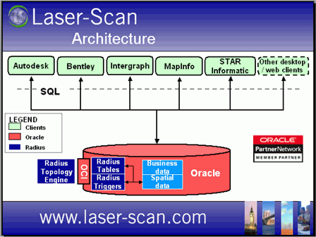
Click image for larger view.
Laser-Scan has taken the common store concept a step farther by incorporating two key features:
- Data cleansing and topology corrections on the fly, from both CAD and GIS files, as the data is placed in the common store in Oracle.
- Faster spatial queries, because the queries can be more precise in their scope.
When considering using any software that is designed to work with several other platforms, the question I always have to ask is, "How much of an issue is it to get this software to work with what I have in place?" Radius Topology states that they seamless integrate with Autodesk, Intergraph, MapInfo and STAR Informatic GIS products.No modifications, no plug-ins, it just works transparently.Radius Topology is presented by Laser-Scan as the "Universal Component" for common data storage in Oracle.
Other advantages are that everything is working on the server side, therefore allowing for very thin clients.Like all software of this scope, it also has to be very scalable - what starts out as a good idea and initially works doesn't quickly become eclipsed by the volume of users or the number of transactions.
Radius Topology uses these Oracles features:
- Native support of spatial data types
- Spatial indexing.
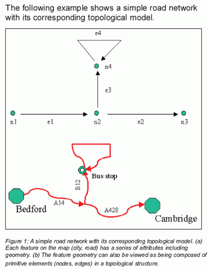
Click image for
larger view.
...to this....
This way, users can take advantage of all the standard database features of table joins and queries, linking, etc.The Radius Topology claim to fame is that the data will be clean, polygons will close and linear features will go from beginning to end.
If you want to bring several departments together into a common data store and are now using Oracle 9i or later, it would appear to be worth a conversation with Laser-Scan about this product.
From Our Homepage
Saying Farewell to an Amazing Journey
Communicating with Maps
Is There a GIS Career Ladder?
What does it mean to be geospatially smart? Series
Ways Real Estate and Property Developers Utilize Melissa GeoData for Data-Driven Decisions
Unlocking Value From Daily Satellite Imagery and Insights
Maximizing the Value of Your Address Data with Geo Addressing
How Indoor Mapping Enhances the Security of Smart Buildings
Look Ahead: AI, Location Intelligence and Efficiency
Collaboration Takes on Sea Level Rise & Dynamic Technology Environments
Brownies for Brownfields
Has Everything Been Mapped Already?
How Is Data Literacy Changing in an Artificial Intelligence Landscape
Portfolios for GIS Professionals: More Than Just Maps
How to Create a Distance Matrix in QGIS - A Step-by-Step Guide
7 Ideas for Bringing GIS into the K-12 Classroom
The Geography of Movement