Our
health may be at risk, reports the U.S. Fish and Wildlife Service
(FWS). The agency, whose mission it is to monitor and manage threatened
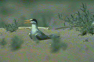
and endangered wildlife, reports that bird populations are plummeting
at an alarming rate and the health of our feathered friends is "a
critical indicator of the health of the environment on which we all
depend."
One way the agency is keeping an eye on threatened and endangered birds is by collaborating with the U.S. Army Corps of Engineers (USACE), New York District. The agencies collaborated in the creation of a website that is supported by a geographic information system (GIS). The GIS serves as a user-friendly repository of information on threatened and endangered bird and plant species living along the New York and New Jersey coasts. Scientists, decision makers and interested citizens can use this information to come up with joint solutions for protecting these species. The website is called the Threatened and Endangered Species System (TESS).
"The purpose of the website is to provide a central point of data entry for surveys and site observations related to threatened and endangered species," said Rose Dopsovic, GIS contractor, Army Corps, Mobile District, who is assisting the New York District.
The goal of the Threatened & Endangered Species System (TESS) website is to effectively manage the data storage of threatened and endangered species observations.
In the past, USACE did not have a defined protocol for data collection and storage of species observation data. Not having a centralized and organized source for this information made it difficult for project managers to compile the necessary season summary reports and spatially view the locations of threatened and endangered populations.
Inputting Data on the Website
The TESS website allows authorized users, as defined by the USACE project manager, to input site observations of the threatened and endangered species into a database. The observations include data extracted from daily and end-of-the-season summary on-site surveys.
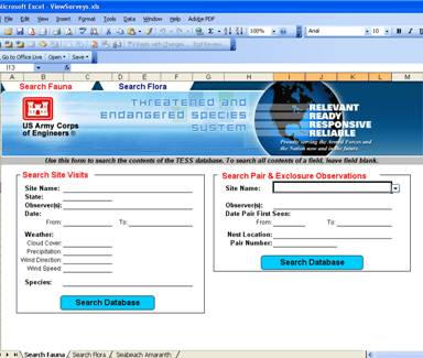
The TESS website provides downloadable Microsoft Excel forms for each of the species currently supported by TESS (see accompanying image).
When completed, the observation forms are automatically transferred to the USACE project manager via email. Upon receipt, the project manager reviews the submission, makes any required modifications, and uploads the forms’ content into the centralized TESS database.
This upload is automated through a number of database-stored procedures accessible through custom Microsoft Excel forms. The original Excel submission is also maintained and archived in the TESS standard file architecture.
Searching Data on the Website
Once the data observation forms are submitted to the TESS database, users can download, browse or query the database content.
Some database content is sensitive, therefore public access to active datasets is restricted until the active nesting or growing season is complete. To obtain access to active season data, a user must be designated as "authorized" by the project manager and will be issued a username and password for data access.
To browse or query the database content, a Microsoft Excel search form is available for download from the TESS website. This Excel form contains a read-only connection to the centralized TESS application. The user can select from a variety of search variables (see accompanying images).
The "Mapping Data" page of the TESS website allows all users to download auto-generated Google Earth KMLs and comma separated text files of database content. Only authorized users are able to view active season content.
The automatic generation of these files provides the users with the most up-to-date information directly extracted from the TESS database. A KML file, native format for Google Earth, is built from coordinates submitted to the database to reflect the location of the site observations and site observation details.
If the user prefers to simply download the full database content, a hyperlink is available that will prompt the user to download full database details for the selected species.
 |
One way the agency is keeping an eye on threatened and endangered birds is by collaborating with the U.S. Army Corps of Engineers (USACE), New York District. The agencies collaborated in the creation of a website that is supported by a geographic information system (GIS). The GIS serves as a user-friendly repository of information on threatened and endangered bird and plant species living along the New York and New Jersey coasts. Scientists, decision makers and interested citizens can use this information to come up with joint solutions for protecting these species. The website is called the Threatened and Endangered Species System (TESS).
"The purpose of the website is to provide a central point of data entry for surveys and site observations related to threatened and endangered species," said Rose Dopsovic, GIS contractor, Army Corps, Mobile District, who is assisting the New York District.
The goal of the Threatened & Endangered Species System (TESS) website is to effectively manage the data storage of threatened and endangered species observations.
In the past, USACE did not have a defined protocol for data collection and storage of species observation data. Not having a centralized and organized source for this information made it difficult for project managers to compile the necessary season summary reports and spatially view the locations of threatened and endangered populations.
Inputting Data on the Website
The TESS website allows authorized users, as defined by the USACE project manager, to input site observations of the threatened and endangered species into a database. The observations include data extracted from daily and end-of-the-season summary on-site surveys.
 |
The TESS website provides downloadable Microsoft Excel forms for each of the species currently supported by TESS (see accompanying image).
When completed, the observation forms are automatically transferred to the USACE project manager via email. Upon receipt, the project manager reviews the submission, makes any required modifications, and uploads the forms’ content into the centralized TESS database.
This upload is automated through a number of database-stored procedures accessible through custom Microsoft Excel forms. The original Excel submission is also maintained and archived in the TESS standard file architecture.
Searching Data on the Website
Once the data observation forms are submitted to the TESS database, users can download, browse or query the database content.
Some database content is sensitive, therefore public access to active datasets is restricted until the active nesting or growing season is complete. To obtain access to active season data, a user must be designated as "authorized" by the project manager and will be issued a username and password for data access.
 |
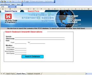 |
To browse or query the database content, a Microsoft Excel search form is available for download from the TESS website. This Excel form contains a read-only connection to the centralized TESS application. The user can select from a variety of search variables (see accompanying images).
The "Mapping Data" page of the TESS website allows all users to download auto-generated Google Earth KMLs and comma separated text files of database content. Only authorized users are able to view active season content.
The automatic generation of these files provides the users with the most up-to-date information directly extracted from the TESS database. A KML file, native format for Google Earth, is built from coordinates submitted to the database to reflect the location of the site observations and site observation details.
If the user prefers to simply download the full database content, a hyperlink is available that will prompt the user to download full database details for the selected species.
From Our Homepage
Saying Farewell to an Amazing Journey
Communicating with Maps
Is There a GIS Career Ladder?
What does it mean to be geospatially smart? Series
Ways Real Estate and Property Developers Utilize Melissa GeoData for Data-Driven Decisions
Unlocking Value From Daily Satellite Imagery and Insights
Maximizing the Value of Your Address Data with Geo Addressing
How Indoor Mapping Enhances the Security of Smart Buildings
Look Ahead: AI, Location Intelligence and Efficiency
Collaboration Takes on Sea Level Rise & Dynamic Technology Environments
Brownies for Brownfields
Has Everything Been Mapped Already?
How Is Data Literacy Changing in an Artificial Intelligence Landscape
Portfolios for GIS Professionals: More Than Just Maps
How to Create a Distance Matrix in QGIS - A Step-by-Step Guide
7 Ideas for Bringing GIS into the K-12 Classroom
The Geography of Movement