"We were lucky to have some CADD drawings for a [water or wastewater] line," said Troy Austin, ACSA project engineer. "Everything was managed by employee memory or paper drawings. It was low reliability as to where the utilities actually were."
To continue to provide effective service for approximately 12,000 customers in this rural area, ACSA decided to implement an advanced geographic information system (GIS) to manage its water and wastewater systems.
The Approach
Like many local government agencies, ACSA had
been relying on utility drawings, computer aided design and drafting (CADD),
and employee knowledge to manage its systems. Although ACSA had CADD-based
water modeling software, the specific information it provided limited its
usefulness. To solve this problem, GeoDecisions, a software-independent
consulting company and ESRI business partner, was selected to develop,
integrate, and customize a robust data model and to design custom applications
to meet ACSA's management needs.
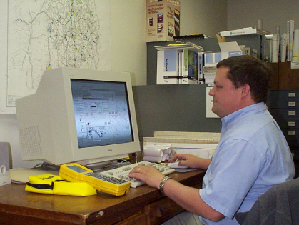 Troy
Austin updates features in the water system, using the ArcGIS maintenance
interface developed by GeoDecisions
Troy
Austin updates features in the water system, using the ArcGIS maintenance
interface developed by GeoDecisions
"GeoDecisions has extensive experience in setting
up GIS throughout the state," said Austin. "They looked at the RFP
and tried to figure out exactly what we wanted. They had gone that
extra step. Needless to say, we have not been disappointed."
Maintaining network connectivity and data integrity were ACSA's primary goals. ESRI's ArcGIS and Geodatabase were selected as the tools to develop the new GIS. The Geodatabase design was based on ESRI's water and wastewater data model. GeoDecisions worked with ACSA to customize this model to reflect the real world features in its water and wastewater systems. "We anticipate that GIS will help to keep things maintained and take less time to do it," said Austin.
Data Creation Process
After GeoDecisions completed the Geodatabase design,
ACSA's existing data layers were updated and new layers were created, using
a combination of global positioning system (GPS) technology and as-builts
(utility drawings). Water meters, pumps, tanks, manholes, and other
major point features were captured with GPS and imported into the Geodatabase.
Scanning and georeferencing ACSA as-builts and other sketches in ArcMap
8.1 allowed GeoDecisions to place water and wastewater mains in the correct
locations. The scanned as-builts were also used to create and verify
attribute data of the various features.
Next, ACSA wanted an easy way to retrieve and maintain GIS data, in addition to updating and adding new features. A water/sewer data maintenance application was created by customizing ArcMap 8.1 with ArcObjects and Visual Basic for Applications (VBA). This custom application allows users to interactively view and edit the attributes of a chosen feature with standardized entry forms. The application also recognizes the addition of a new feature to the geometric network and automatically displays the attribute interface to the user. When a new feature is created, the application adds it to the Geodatabase, sets any default values based on established Geodatabase rules, and allows the user to enter any attribute information immediately.
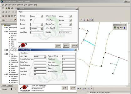 The
Water Maintenance Application Interface. These custom forms allow
users to easily manage the attribute data of each network feature.
The
Water Maintenance Application Interface. These custom forms allow
users to easily manage the attribute data of each network feature.
Integration with Billing System
After completing the data conversion process,
the focus of the project shifted to integrating the new GIS database with
existing non-geographic data management tools. ACSA currently uses
a mainframe billing database and server for water meter information.
However, to provide a more efficient means for retrieving this information,
a custom billing application was developed to incorporate the billing data
with the meter data in the Geodatabase. This application allows the
user to obtain current and past billing information for a chosen water
meter, search for meters meeting certain criteria, or to select data for
calculations and analysis. The application provides powerful graphing
functions to allow the user to view billing history data and other information.
Utilizing Existing Analysis Tools
ACSA also wanted the ability to extract new data
from the Geodatabase for use in its water modeling software. Many
organizations and local governments are reluctant to upgrade to an advanced
GIS, because they rely on older, established analysis software. These
existing software packages often require data in a very specific format.
Converting the new data format to match the previous data format can be
difficult. This occurred with ACSA's water modeling software, H20Net
Analyzer by MWH Soft, Inc.
H20Net is an AutoCADD-based water analysis program. Its data format differs greatly from the traditional GIS standards used in Geodatabase data. For example, valves normally represented as points in GIS need to be line segments in H20Net. To correct this, a custom tool was developed to convert existing GIS data to the required data format for H20Net. The export tool was developed in ArcGIS 8.1 using ArcObjects and VBA. All attribute information was populated and converted to meet H20Net's demands. This resulted in a tool that successfully exports data from the Geodatabase into shapefiles, formatted for importing directly into H20Net for analysis.
So far, ArcGIS and Geodatabase have only been implemented in one of ACSA's service areas. Austin expects the system to be in operation county-wide within three to four years. "I'm looking forward to it being completed," said Austin. "I think it's going to be a very useful tool for us [ACSA] and the community. From an engineering/customer service standpoint, it's going to greatly improve how we can respond to customer service requests."
In the future, ACSA is considering moving from a personal Geodatabase to an ArcSDE solution. ACSA is also looking into the possibility of hosting its GIS online for other ACSA employees and the public to use.
Authors: Garnet Daus is the public relations coordinator;
Sara Kidd, a senior GIS analyst;
and Bryan Reid, a GIS programmer, for
GeoDecisions.
For more information, visit GeoDecisions on the web at http://www.geodecisions.com/ or contact Donald Cole, vice president, GeoDecisions, at (757) 873-0768 or dcole@geodecisions.com. ACSA is online at http://www.acsawater.com/or contact Troy Austin, project engineer, at (540) 245-5670 or taustin@co.augusta.va.us.
# # #