 Bass
Delivers Autodesk University Keynote
Bass
Delivers Autodesk University Keynote
This year's keynote at the Autodesk University Conference in Las Vegas
(Dec.1-4) was given by Carl Bass, Senior VP, Design Solutions Group.Mr.
Bass noted that while in the last 20 years, the PC was 1,000 times faster
and dramatically better; software generally could not make this same claim.
Read more from his keynote address by senior contributing editor, Hal Reid.
 Expanding
the View: What You Really Need are Three 17-inch Monitors for True GIS
Visualization
Expanding
the View: What You Really Need are Three 17-inch Monitors for True GIS
Visualization
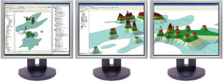
Sometimes the obvious has to hit you right in the nose.Multiple monitors
are one of those things that you know about, have worked with, and you
forget just how cool they can be until you see them done right.That's
really what you need for true geospatial visualization.
 CAD,
GIS Integration: Why Would You Want to Do This Anyway?
CAD,
GIS Integration: Why Would You Want to Do This Anyway?
In many ways CAD and GIS are like oil and water.The CAD people see
their work as engineering-based with high precision placement and accurate
measurement.They view GIS as neither precise nor accurate.The GIS people
see their work as larger scale (who wants a map at 1:40 or 1:20?) and cartographic
in nature rather than pure engineering.It is not that GIS-ers do not want
the accuracy; it is just a lot harder to do over large geographies.Read
Senior Contributing Editor Hal Reid's "unbiased and open-minded" opinion
on this issue!
 Project
Lifecycle Management: A commentary.
Project
Lifecycle Management: A commentary.
Autodesk has a core concept of Lifecycle Management as an application
for their products.That is, incorporating information from the initial
design of a project through the construction and management of the end
product, whether that project is a building or an item that is manufactured.
Autodesk, however, at first blush, they seem to be missing the entire story.
Read more of Senior Contributing Editor Hal Reid's notes from Autodesk
University.
![]() Temporal
GIS - at Last
Temporal
GIS - at Last
Temporal GIS is finally here.No more slide shows of .jpg files or
cut and pasting into Power Point just to show things like 2000, 2003 and
2007 demographics.While these techniques worked, it was never quite what
you wanted to show and always was clunky.