What's new about this? Although the company has facilitated solution development in the past, Autodesk has more thoroughly developed their services organization to support them.It is a strategy that represents an evolutionary, yet still radical, approach for a company that has been more product-driven. This past Monday, the company announced a new suite of solutions in the public works arena, which augments other existing solutions such the company's Emergency Response Solution, which is comprised of Autodesk® Crisis Command and Autodesk® Mobile Command software.
Autodesk realizes, however, that to get to a solution "sell," it must also have in place the product architecture to be coincident with this approach.It is doing two things to accomplish this:
- It is encouraging its customers to migrate from file-based management to object oriented software solutions integrated with relational database (RDBMS).The reason is to make sure that feature attribution is not striped away in the conversion of CAD files to the RDBMS.
- Promote the evolution to model-based design - e.g.the Civil 3D product helps to bring model-based design to GIS.Civil3D is a superset of Map 3D and thereby integrates with map-based data.Map 3D (built on AutoCAD) maintains attribution, which can be stored in an RDBMS.
 A key component of this strategy is Autodesk's relationship with Oracle.
Autodesk is relying on many of the new features of Oracle 10g to specifically
enable its customers to think about the many ways to share geospatial information.
Autodesk Map, for example, can write to a file-based management approach
or to an RDBMS, in this case Oracle Spatial.The delivery platform to share
information from any of Autodesk's suite of products is MapGuide, its internet-based
mapping software.
A key component of this strategy is Autodesk's relationship with Oracle.
Autodesk is relying on many of the new features of Oracle 10g to specifically
enable its customers to think about the many ways to share geospatial information.
Autodesk Map, for example, can write to a file-based management approach
or to an RDBMS, in this case Oracle Spatial.The delivery platform to share
information from any of Autodesk's suite of products is MapGuide, its internet-based
mapping software.
Bradshaw sees that both data management environments need to be supported but that the file-based way of capturing CAD drawings will co-exist for many years.If starting from scratch, he believes that the RDBMS may be a better solution.When asked if a specific customer base had a greater need to take a more enterprise approach to data management, Bradshaw said that telecommunication companies are pushing the move to an RDBMS."They are feeling more of the pain," he said, specifically for data management and information sharing with GIS systems perhaps more than any other industry, but with the government sector being next.
 Relying more on Oracle 10g will allow Autodesk to leverage many of the
features that perhaps had been viewed as weaknesses before, such as persistent
topology long-term transaction processing, and security.In addition, 10g's
presentation of a new data type, Georaster, helps to support satellite
imagery and digital terrain data.Its network model will store and maintain
connectivity, store attributes at link-node level, and perform network
analysis functionality in the database for traveling salesman algorithms
and to delineate catchment zone models, significantly enhancing the services
organizations development of solutions for which Autodesk might never have
attempted previously.
Relying more on Oracle 10g will allow Autodesk to leverage many of the
features that perhaps had been viewed as weaknesses before, such as persistent
topology long-term transaction processing, and security.In addition, 10g's
presentation of a new data type, Georaster, helps to support satellite
imagery and digital terrain data.Its network model will store and maintain
connectivity, store attributes at link-node level, and perform network
analysis functionality in the database for traveling salesman algorithms
and to delineate catchment zone models, significantly enhancing the services
organizations development of solutions for which Autodesk might never have
attempted previously.
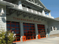
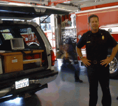
Customers, such as one of its neighbors -- the Tiburon Fire Protection
District - are relying on Autodesk's Mobile Command Solution to transform
a once paper map book approach to a completely digital system for getting
information to battalion commanders and firefighters in both emergency
situations and routine fire inspections.Battalion Chief Ed Lynch (at right)
said that having a "single point source of information for multiple applications
is key and giving maps to first responders is vital to good communication."
Two command vehicles will deploy a hardened laptop computer to field operations.
Half of the fire district's staff is trained to use the new system, which
is becoming a critical need as the district is losing many firefighters
to retirement.And with the state's financial situation, hiring replacements
is squeezed.The move to a more "high-tech savvy" staff will allow firefighters
to react more quickly with better information for both natural disasters
and homeland security situations.