
Each year, Bentley
Systems nominates projects in
which its user's have been engaged over the past year for one of their
"Awards of Excellence" in a specific discipline.In Geospatial,
thirty-one projects were nominated in five categories.Directions
Magazine Editor-in-Chief,
Joe Francica, was one of the adjudicators along with Carey Mann and
Styli Camateros, vice presidents of Bentley, and Matt Ball, Editor of
GEOWorld Magazine.The projects represented a diverse cross section of
applications that were submitted from local governments, federal
agencies, utilities, engineering firms and research laboratories.Greg
Bentley, CEO, commented that he always enjoys being involved with these
projects because they have a conclusion, a finished result.The awards
were announced
at a dinner in their honor and hosted by Alan Farkas of Farkas
Berkowitz & Company, a Washington-based management consulting firm.
This year's award winners are listed below.
| Award
Category |
Submitting
User - Project Name |
Project
Information & Highlights (Source: Information provided from award submission material) |
Project
Example |
| AEC-GIS
Vision |
Oldham
Metropolitan Borough
Council, United Kingdom - Environmental Protection Management Project |
Oldham and its
districts were at the heart of
the Industrial Revolution.This brought with it prosperity but left a
legacy that required investigation.Through the use of Bentley V8
Geographics, PowerMap, Descartes, Publisher, NTF Translator and
particularly the benefits of Training Subscription this dilemma was
successfully resolved.Bentley's versatility even allowed Oldham to
link into non-ODBC compliant databases.Historic raster maps were made
available by means of Descartes warping
and locating tools.These provided a backdrop that was not available or
possible before.Being able to quickly load, manipulate and view these
raster files has allowed investigations to be carried out at the users
desk. The project was started in April 2003 and was completed for use in July 2003.The Bentley based corporate infrastructure previously installed allowed this project to be achieved at a cost of approximately £11,000. |
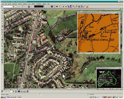 Click image
for larger view
|
| Extreme
Mapping |
City
of Toronto, Canada - 3D
Topographic Mapping |
In just nine
months, the entire topographic
mapping base for the City
of Toronto had been rebuilt.To date, the City of Toronto has collected
over six million features across the entire city, including 427,392
building outlines, 1,174,297 trees (differentiated by public and
private, coniferous and deciduous), 132,893 catch basins, 187,805
streetlights and 36,852 hydrants.The project has cost approximately $4
million to date, but has saved the City of Toronto an estimated $7
million. Data stored in the MicroStation Geographics files; all vectors contained in the DGN file are linked to a table stored in an Oracle database that describes the vectors.The fundamental challenge of rebuilding the City of Toronto's topographic mapping base and being able to maintain it in a cost efficient manner was achieved through the development of an environment called Enterprise Stereoscopic Model (ESM).The ESM consists of two major components: an aerial image vectorization program combined with MicroStation Geographics. |
 Click image
for larger view
|
| Integrated
City |
Gdansk
Development Agency -
Urban planning as part of the Gdansk Municipal GIS |
In June 1999, the
City Council of Gdansk set up
the Gdansk Development Agency (BRG).The main task of this organization
was to produce local urban plans in order to ensure sustainable
development of Gdansk, which is more than 1,000 years old and has about
500,000 inhabitants. One of the challenges for a new management team of BRG was to develop an IT system which would allow for the efficient production of local urban plans as well as the effective data exchange between the City Hall and BRG.The system needed to allow for continuous adjustment due to changing legal requirements, which is typical for countries in transition to EU.As a digital base map in Gdansk is maintained in the MicroStation/GeoGraphics format, the same platform was chosen for developing applications to be used in BRG.To date both software and hardware related expenditures have amounted to about $400,000 USD.Some of the benefits realized by the project was that the time of production of one local urban plan was shortened by about 50% and there was a significant increase in quality and coherence of plans. |
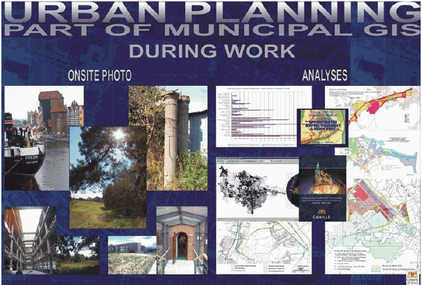 Click image
for larger view
|
| New
Technology Adoption |
City
of Helsinki, Finland,
City Survey Division - 3D Municipal Information System |
A general 3D model
of whole city territory was
completed in the year 2002.This model was created from the 2D base map
database, city's building cadastre and orthophotos.Laser scanning and
digital photogrammetry were used in collecting 3D information of built
and terrain objects.The general 3D model was used in the Helsinki
Master Plan 2002 project, which was approved by Helsinki City Council
in November 2003.The accurate 3D city model, which is replacing the
digital 1:500 base map, is widening constantly and is used in many city
planning and construction projects. Laser point clouds and orthophotos have been applied in mapping out dated map features and in vectorizing 3D buildings and 3D streets manually, semi automatically and automatically.In modeling, MicroStation was used as well as TerraScan, TerraPhoto and TerraModeler software packages, which are developed in Finland for 3D modeling purposes. |
 Click image
for larger view
|
| Spatially
Enabled Managed
Environment |
Proyecto
de
Administracion de Tierras de Honduras (PATH) - Sistema Unificado
de Registro (SURE) |
PATH is a World
Bank financed project.The Land
Administration Project of Honduras has as its main objective
development of an
integrated and decentralized land administration system (composed of
public and privates entities) to provide users in the project area with
accurate information on urban and rural land parcels and effective land
administration services (purchase, mortgages, cadastral and registry
certifications, etc.) in a timely and cost effective manner.The
Unified System of Registries (SURE) is part of the National System of
Property Administration (SINAP) and is a pivotal tool of PATH.It has
been
conceived with the purpose of administering the rights of property that
fall on personal property and real estate in Honduras.The scope of
administration extends to the geometric and alphanumeric attributes of
these goods and their respective legal reference. SURE is built under a multi tier web architecture that allows complete access through the intranet of the project and related institutions. The development of the first phase of SURE started in September of 2002 and was finalized in October of the 2003.This first phase includes the management of the information of the offices of Cadastre and Real Estate Property and the production process of the Project: a massive process of investigation and legalization.SURE was developed with an approximate cost of US$270,000.00 (without including the cost of development software). PATH has a ProjectWise Extranet server to enable work in a managed environment.SURE has used the SDK API of ProjectWise to build a web base system to manage each legalization request.It is expected that more than 800,000 legalization requests will be managed in ProjectWise following a workflow operated by each municipality, the Instituto Nacional Agrario (INA) and PATH. |
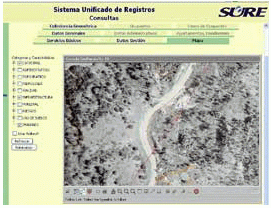 Click image
for larger view
 |
From Our Homepage
Saying Farewell to an Amazing Journey
Communicating with Maps
Is There a GIS Career Ladder?
What does it mean to be geospatially smart? Series
Ways Real Estate and Property Developers Utilize Melissa GeoData for Data-Driven Decisions
Unlocking Value From Daily Satellite Imagery and Insights
Maximizing the Value of Your Address Data with Geo Addressing
How Indoor Mapping Enhances the Security of Smart Buildings
Look Ahead: AI, Location Intelligence and Efficiency
Collaboration Takes on Sea Level Rise & Dynamic Technology Environments
Brownies for Brownfields
Has Everything Been Mapped Already?
How Is Data Literacy Changing in an Artificial Intelligence Landscape
Portfolios for GIS Professionals: More Than Just Maps
How to Create a Distance Matrix in QGIS - A Step-by-Step Guide
7 Ideas for Bringing GIS into the K-12 Classroom
The Geography of Movement