 "Mobile
professional will only have to open their devices and make it work," commented
Zeglis.AT&T will be the first wireless carrier to use MapPoint .NET
technology and AT&T's own technology in providing location services.
From the press release today, the companies stated, "This integration will
unlock a new generation of services that combine locating colleagues with
capabilities such as obtaining maps and driving directions, conducting
proximity searches, and finding destinations and points of interest near
one's own or a colleague's location.This solution is completely integrated
with the instant messenger and Outlook clients on Pocket PCs and notebooks."
"Mobile
professional will only have to open their devices and make it work," commented
Zeglis.AT&T will be the first wireless carrier to use MapPoint .NET
technology and AT&T's own technology in providing location services.
From the press release today, the companies stated, "This integration will
unlock a new generation of services that combine locating colleagues with
capabilities such as obtaining maps and driving directions, conducting
proximity searches, and finding destinations and points of interest near
one's own or a colleague's location.This solution is completely integrated
with the instant messenger and Outlook clients on Pocket PCs and notebooks."
In speaking with Steve Lawler, Product
unit manager for MapPoint .NET and Steve Lombardi, MapPoint Technical Product
Manager, corporate users are the first target market for three primary
applications:
- "Find your buddy" application: This will rely on location-enabled corporate instant messaging (IM).Corporations using Microsoft Exchange and Outlook will be able to take advantage of an opt-in service that provides a means for communicating among employees so long as they subscribe to the same wireless service.From the press release, "to simplify access from any wireless-ready laptop to Microsoft Exchange and the Microsoft Outlook® messaging and collaboration client over corporate virtual private networks (VPNs), the companies have developed a custom one-button-synch software wizard that will provide easy access over the AT&T Wireless high-speed data network."
- Personal concierge services: Recognizing that there is now a highly mobile workforce, the two companies want to be able to provide driving directions for meetings and perhaps integrate this service with the corporations existing CRM data.For example, a sales manager may want to determine "which one of my customers that has done $1 Million of business with me in the last year is within driving distance?"
- Find your contacts in real-time: For example, if a person or group is late for a meeting they may want to contact them and determine exactly where they are located in proximity to the meeting venue.The object for the "lost" party may be to "get directions now!" and this may be determined using Pocket Outlook where location is at its core.
Microsoft sited overwhelming
market research pointing to positive acceptance of this service especially
for real-time demand for maps.Microsoft & AT&T feel that they
have helped to redefine the marketplace and help free "knowledge workers"
from their desk.AT&T will make sure a full range of wireless devices
are available through AT&T to the marketplace.AT&T will help to
make it simple to get up and running quickly.Joint development of location-based
services, co-selling, and co-marketing applications between the two companies
is forthcoming.
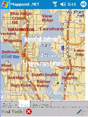
The service will use a multi-tiered
architecture.On the client side, software residing on the Pocket PC device,
such as an IM resident program will "talk" to a MapPoint .NET server, which
makes the proper call to the MapPoint service, and then makes the call
the AT&T's network, using the credentials of AT&T network for security.
AT&T provides an API to acquire location data so that MapPoint is used
to deliver and visualize the location information.
The only disappointing element in this announcement is that the positioning determination equipment (PDE) used to locate users will only be to the nearest cell tower using a simple triangulation method.In a major city, users will be able to locate "buddies" within a few blocks, but the proximity worsens in less populated or rural areas.The cost for the service has not yet been determined.
For more information, read the press release and see the FAQ on Microsoft .NET.