In the wake of the fires, we, the Remote Sensing Applications Center
(RSAC) of the USDA Forest Service, have provided support to the Burned
Area Emergency Response (BAER) field teams.A cooperative effort between
RSAC and the USGS, the two centers team up to provide rapid delivery of
satellite imagery, Burned Area Reflectance Classifications (BARC) and other
geospatial data to field teams.
The BARC process is a preliminary classification of satellite imagery that shows fire effects on vegetation reflectance.Using Leica Geosystems' ERDAS IMAGINE, our analysts first terrain-corrected the imagery if necessary. (Some vendors provided imagery already terrain-corrected and sufficiently geo-located.) To produce the BARC maps, our analysts ran models developed specifically for the IMAGINE system.These models incorporate a technique using the normalized burned ratio d(NBR) technique, or a ratio of different spectral bands.These ratios were run on pre- and post-fire images, after which we performed a change detection between the two dates.Next we stratify-ratioed spectral bands to create the different burned area reflectance classes. BARC products have four classes: high, moderate, low and unburned/very low.

Click for larger image
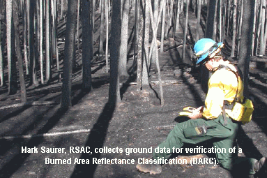
In addition to the four-class BARC image, we also provide the field teams an unclassified version of the BARC.This 256-value thematic image allowed users to adjust or create new break points between the burn classes based on what they observe in the field.They use additional information such as field inventory plots, soil types, slope and aspect to modify the classes.Along with field verification, these steps resulted in a burn severity map.
Timing was a critical issue in this project.Information is of no value to the field crew if it is not delivered promptly, because BAER field teams have ten days from fire containment to submit their assessment to Forest Supervisors.Obtaining, processing and delivering the processed imagery back to the field units within that short time frame was a big challenge. We have streamlined the process by developing image-processing modules to automate nearly all the steps involved in the process.It was imperative that we acquire remotely-sensed imagery quickly from a provider, be it from a satellite system, private vendor or government agency.
Using remote sensing for this type of scenario is beneficial with such a project because RSAC can cover large areas effectively.If we have a good imagery source, remote sensing provides a comprehensive overview of the whole burn area.In turn, we can quickly, objectively and consistently classify the imagery to get to the burned area reflectance classification product and repeat steps as needed.If imagery is not available, the alternative is to conduct a flight mission in a light aircraft and basically sketch polygons of the different categories.This is a less efficient and objective way of mapping burn severity.
This project is ongoing, as we do this procedure for all fires throughout the fire season.For these particular wildfires, we were able to turn around the information quickly and with accuracy.
Remote sensing serves the Forest Service in multiple ways.Several of RSAC's many projects include using the ERDAS system to produce vegetation land cover classification of satellite imagery, information that is valuable for forest planning.We are using imagery with field inventory plots to help arrange and manage field inventory efforts more effectively.Additionally, we use remote sensing to monitor change detection within forests over time.

RSAC is responsible for providing technology evaluation and development and training support in the use of remote sensing, GIS, image processing and GPS for all resource applications, with emphasis on ecosystem management. We provide technical support in evaluating and developing new technology, operational support to the geospatial community in the Forest Service and training in technical support to users.Overall, our main goal is to facilitate the implementation of remote sensing technologies within the Forest Service at all different levels, from entry-level to advanced levels.
We envision that the role of remote sensing in our world will continue to expand in the future.As we can already see happening, image processing and GIS will become much more integrated.People who are familiar with GIS are also becoming more familiar with image analysis techniques.We are excited about this integration and will continue to work on projects where these two different technologies are integrated.We are doing everything possible to make resource specialists and managers such as foresters, soils scientists and biologist understand how imagery can make their jobs easier.
For more information about the USDA Forest Service's Remote Sensing Applications Center, call (801) 975-3750 or visit www.fs.fed.us/eng/rsac.
All images courtesy of the USDA Forest Service Remote Sensing Applications Center.