 |
Dr. Curt H. Davis, Ph.D., director of the Center, said at a press conference on January 3, "Geospatial Intelligence provides critical spatial information to a decision-making process that is necessary for meaningful actions and decisions. In a technical sense, it is the fusion or integration of multiple forms of data collected from satellite and airborne sensors, along with a wide variety of other digital geographic information." Some of the concepts applied here are not dissimilar to the concepts of Location Intelligence that we use in business.
We need to stay abreast of the activities of these kinds of groups because they are on the cutting edge of technology, and we will likely be absorbing what they create in the future for our own use. They will do the research, work out the bugs, and develop the experts on whom we will rely.
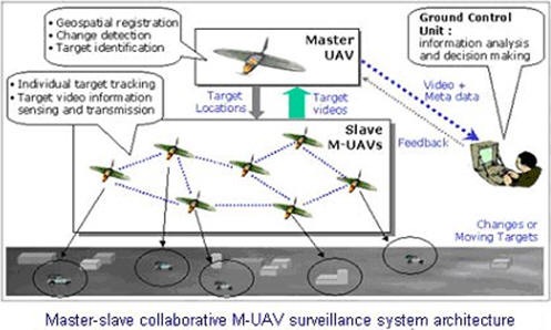
Let’s look at several of their projects. In January 2006’s Directions on Data newsletter, we re-published a paper by Dr. Zhihai He. He wrote about using multiple UAVs (unmanned aerial vehicles) to create a composite geo-rectified video data stream. The concept was to use a master UAV, driven by a number of slave UAVs, all sending data to the master. The master UAV would then process and merge the coverage areas of each slave UAV into a single image. Used as an imagery resource, this technology could make available data well below sub-meter imagery, ortho-rectified and geo-registered over very large geographic areas. This would allow us to see markets in greater detail, including proposed locations down to the individual driveway level, and perhaps determine whether the debris on the property was from Burger King, MacDonald’s or Taco Bell!
 |
Moving large amounts of image-derived data involves compression and some transmission (moving that data). The infrastructure in moving, managing, processing, and retrieving data and converting it into knowledge is as important as the data itself. It’s the same concept as fighting fire – if you can’t get the water to the fire, it doesn’t help very much. Moving and using large amounts of data is very important for Location Intelligence.
To quote from the introduction to the Center’s research and development project on Smart Databases and Content Based Image Retrieval (CBIR): “Searching for relevant knowledge across heterogeneous imagery intelligence databases requires an extensive knowledge of the semantic meaning of images, a keen eye for visual patterns, efficient strategies for collecting and analyzing data, and a deep understanding of related tradecrafts (signal intelligence, measurement intelligence, etc.).” In the Smart Databases and CBIR project, interoperability (e.g. having everything from disparate sources work together) is given as much importance as it is given in Business Intelligence and Location Intelligence. [For Content Based Image Retrieval definitions, see The Code Project or from Carleton University.]
But in the Center’s context, this isn’t just various data sources – it includes the movement of data, data processing, and ultimately the creation of knowledge. Still, data must be queried in order to extract information. When it come to very large data sets (new acronym – VLDSR – very large data set retrieval), this not only involves complex queries, but as the Center’s website states:
“By complex queries, we mean a combination of scientific expertise and algorithms to detect and retrieve information related by image features, annotations, geospatial information, vectors, human intelligence, etc. even when those data are not uniformly present in the partner databases.”This expands the concept of interoperability beyond our typical definition.
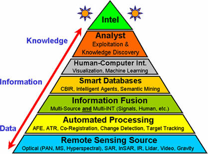
The Center uses the image below to show the bi-directional flow of collection, transmission, processing and the development of knowledge (Intel), further described here.
 |
We are entering an era of Location Intelligence in which the availability of very large data sets, imagery, new methods of extracting pertinent information, and the ability to process that information will enable a new level of understanding of what exists or could exist in our world. Resources like the University of Missouri’s Center for Geospatial Intelligence will certainly help move us toward this new level. An understanding of geography will not suffice - we will have to expand our skill sets laterally in order to put a new understanding of Location Intelligence in perspective.
From Our Homepage
Saying Farewell to an Amazing Journey
Communicating with Maps
Is There a GIS Career Ladder?
What does it mean to be geospatially smart? Series
Ways Real Estate and Property Developers Utilize Melissa GeoData for Data-Driven Decisions
Unlocking Value From Daily Satellite Imagery and Insights
Maximizing the Value of Your Address Data with Geo Addressing
How Indoor Mapping Enhances the Security of Smart Buildings
Look Ahead: AI, Location Intelligence and Efficiency
Collaboration Takes on Sea Level Rise & Dynamic Technology Environments
Brownies for Brownfields
Has Everything Been Mapped Already?
How Is Data Literacy Changing in an Artificial Intelligence Landscape
Portfolios for GIS Professionals: More Than Just Maps
How to Create a Distance Matrix in QGIS - A Step-by-Step Guide
7 Ideas for Bringing GIS into the K-12 Classroom
The Geography of Movement