Only 4 years ago, the municipality was formed by the amalgamation of 23 independent communities in 1998 with a mandate from the provincial government of Ontario to cut costs and streamline local government procedures.
The municipality is largely rural and is comprised of an area of about 2,500 square kilometers that includes several small towns interspersed between large areas of agricultural land. The population of the municipality is about 110,000 with 40 percent living in Chatham.
Comments Chris Masterson, General Manager of Engineering Water and Wastewater for the Municipality, "The amalgamation of the 23 communities under a central municipality was really the driving force for implementing an enterprise geographic information system (GIS). It became politically, economically and efficiently necessary."
He went on to say, "A two-stage project was launched by the Municipal Engineering Department. Initially an AM/FM project was implemented that collected all utility information for Chatham-Kent, bringing together diverse bits of information from the former municipalities into one common electronic format. The experience gained from the initial AM/FM project clearly indicated that an enterprise-wide GIS implemented by the municipality could provide a true societal GIS for the community.This would allow its citizens easy interaction with the municipality and access to information about topics ranging from the location of the nearest public high school to the availability and cost of commercial properties within the municipality."
Adds Jeff Ham, Manager of Chatham-Kent's AM/FM/GIS, "The concept of our data warehouse was not to go and change the existing system that the utility company uses or change the existing systems that our tax department uses, it was to allow everyone to continue using the same systems that they had been using. We built tools to basically extract information from that existing data and bring it into the enterprise data warehouse."
Chatham-Kent turned to Orion Technology Inc., (www.orion-gis.com),
a Canadian-based company, for advice. Orion performed a careful needs
analysis, before recommending that the municipality create a Center for
GIS to provide direction and oversight, as well as a data warehouse for
central spatial data management in preparation for implementing its enterprise
GIS.
 Commenting on the Municipality's Center for GIS Masterson indicates that,
"The center coordinates all of the activities that are geographically referenced,
whether it's for the utility company, the police, fire service, or the
customer billing systems in our tax department."
Commenting on the Municipality's Center for GIS Masterson indicates that,
"The center coordinates all of the activities that are geographically referenced,
whether it's for the utility company, the police, fire service, or the
customer billing systems in our tax department."
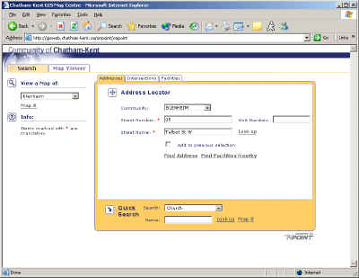
Orion's OnPoint software is the user interface to the Chatham-Kent database and provides fast, intuitive access to the "Map It" tool through the municipality's Community Web Portal with its motto, "Building a Community Through Participation."
The OnPoint application was built using Java technology and ESRI's ArcIMS. Chatham-Kent's Web portal uses ESRI's ArcIMS for corporate viewing across the Internet, ArcSDE for warehousing the data, and GeoDatabase technology for formatting the data.
Diane Gagner, Mayor of Chatham-Kent indicates that the municipality decided to use mapping as the backbone of its community Web portal because, "The GIS is used to drive out all of our "community directories" on the site. There are nearly 100 directories and they include such things as local health services, financial institutions, recreation activities and education facilities. A list of all the available facilities within the directory can be displayed, along with a "Map It" button.Everything in our municipality that can be associated with a location or address has a "Map It" link that will bring you to a fully interactive map of the area where the facility is located. We decided to use GIS mapping as the basis for our Web portal because it is a powerful tool that is key to delivering an effective Web service to the public."
Throughout the Chatham-Kent Community Web Portal, there are more than
3,000 "Map It" buttons or points of entry into the GIS. The "Map
It" tool provides an easy method to display and print maps of locations
found throughout the portal. Two methods of display map are available,
a simple point and click or a more advanced method that allows map customization.
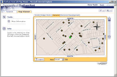 The GIS application has the capability of mapping a location and then finding
services nearby, such as schools, hospitals, golf courses, etc. A
community calendar program is also available, which allows residents to
check the location and availability of public facilities for events to
avoid conflicts.
The GIS application has the capability of mapping a location and then finding
services nearby, such as schools, hospitals, golf courses, etc. A
community calendar program is also available, which allows residents to
check the location and availability of public facilities for events to
avoid conflicts.
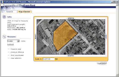
On a displayed map, the user can measure linear distances by simply dragging a line between the two points of interest or calculate the size of an area by tracing around it. Locations can be highlighted on the map and labeled, providing some capability to customize a map. In addition, as you zoom in on an area of interest, the display automatically changes from cartographic to aerial photography, which is visually interesting and very useful.
Mayor Gagner says that, "The average resident or visitor to Chatham-Kent
will be able to use "Map It" to physically locate and review information
about their particular place of interest, from recreation facilities, businesses,
restaurants, financial institutions, doctors offices and golf courses to
name a few. The GIS empowers everyone to explore the entire community
in a convenient and exciting new way without having to set foot outside
their own front door."
 She believes that local business will use "Map It" to, "Establish where
their customers are and how far they will have to travel to carry out their
business. The ability to view and measure distances and areas from
our digital mapping and aerial photography will cut down on travel requirements
and save on "windshield" time for both business and customers, and time
is money. Local business will be able to provide a direct link to
interactive mapping from their website and highlight their location within
the Community by using a "Generate URL" tool. This tool enables
embedding a "Map It" button within the website of the local business.
Before long "Map It" will proliferate not only in websites of local businesses
but also e-mails amongst friends as it is equally easy to embed a "Map
It" button in e-mails. Just imagine birthday party invitation e-mail
with a "Map It" button that will link to an interactive map showing the
location of the party. "Are You Mapping It?" will become a common
topic of conversation amongst Chatham-Kent residents.
She believes that local business will use "Map It" to, "Establish where
their customers are and how far they will have to travel to carry out their
business. The ability to view and measure distances and areas from
our digital mapping and aerial photography will cut down on travel requirements
and save on "windshield" time for both business and customers, and time
is money. Local business will be able to provide a direct link to
interactive mapping from their website and highlight their location within
the Community by using a "Generate URL" tool. This tool enables
embedding a "Map It" button within the website of the local business.
Before long "Map It" will proliferate not only in websites of local businesses
but also e-mails amongst friends as it is equally easy to embed a "Map
It" button in e-mails. Just imagine birthday party invitation e-mail
with a "Map It" button that will link to an interactive map showing the
location of the party. "Are You Mapping It?" will become a common
topic of conversation amongst Chatham-Kent residents.
Agriculturists can use the GIS system to measure the geographic area of farm fields when ordering seed and fertilizer for their farm. The list of applications of this technology is endless."
"The Chatham-Kent 'Map It' concept and tool is a true societal GIS," comments Jack Dangermond, President of ESRI. "It promotes the exchange of information between the municipality and its residents through a simple, yet powerful user interface and provides us with a view of the future of GIS technology."
About the Author
Jim Baumann writes about international GIS-related topics for ESRI.
He has written articles on various aspects of the computer graphics industry
and information technology for more than 15 years.