Mosquitoes are the most common carriers of the disease and have been known to infect birds, horses and humans.People over 55 years of age are considered to be at highest risk of contracting the virus, as their immune systems are weaker.Because Monterey County is one of California's largest retirement communities with a high percentage of senior residents, the county needed to be especially attentive to this virus.
Realizing NASA was doing similar work on the East Coast, the department contacted NASA's research center and in 2003 received a grant from NASA to conduct its own project. The project's main goals were to identify mosquito habitats that can transmit WNV; correlate the habitat with the county's vulnerable population; and create a risk map to help decision-makers effectively combat WNV.Four students from NASA's DEVELOP Program conducted research and analysis for the project.
The project was divided into two phases: in Phase I, the vector maps were created and in Phase II, a dynamic GIS was implemented for virus incident and response tracking.Initially, the areas at highest risk of being infiltrated by the virus had to be identified. This was done by mapping the disease carriers' breeding source and adult habitat areas in correlation with county population.Landsat 7 ETM+ images of the county were acquired.With Leica Geosystems' ERDAS IMAGINE® V8.6 software, supervised and unsupervised classification of vegetation and urban areas were run to identify potential mosquito habitat.Additionally, the students used IMAGINE Spectral Analysis tools for model building and radiometric correction of the studied areas.
The vegetation classification was put into a vector coverage to integrate with other data layers within the ESRI ArcGIS environment.Overlay analysis was conducted to produce three specific layers that targeted the problem.These layers mapped:
- Mosquito breeding source areas
- Adult mosquito habitat areas
- High-risk mosquito source and habitat areas
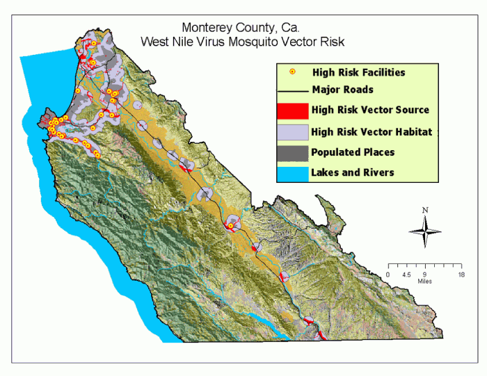
Risk Map.Click image
for larger view.
The Risk Map (above) depicts high-risk areas in red.These are mosquito breeding areas that are located close to densely-populated areas, including hospitals, retirement centers and horse facilities.It appears that such areas required a more aggressive stance in reducing mosquitoes, especially if WNV becomes active in the region.The Surveillance Risk Map (below) shows potential entry points of the virus (near wetlands and mixed forest lands).It also identifies the most high risk mosquito sources and habitats, as well as existing and proposed sentinel flock and mosquito traps.
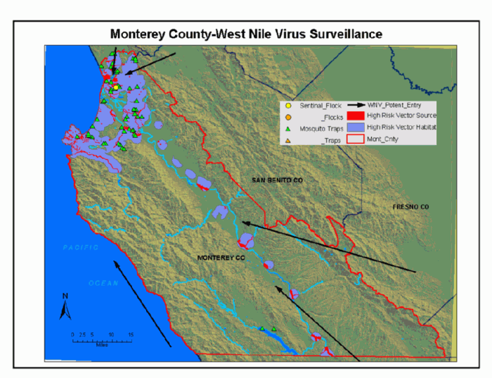
Surveillance Map.Click
image for larger view.
Within IMAGINE VirtualGIS, a fly-through of the county which implements the findings of this project was created.The fly-through model has served as an excellent public education and information tool.It has been very effective in driving home the message to the public that the county is doing everything possible to prepare for possible outbreak of this disease and that citizens must do their part by taking responsibility of their own property.
"The final outputs of this project have helped identify at-risk communities, enhance virus planning and prevention planning and inform land developers seeking building permits become aware of what areas are more at risk," said Darryl Tyler, GIS Analyst, Monterey County IT Department."These maps are also helping influence virus policy and management decision-makers."
The map outputs of Phase I provided a baseline assessment of the county's vulnerability to WNV. This allowed the county to take educated surveillance measures to determine where our limited resources would have the greatest effect.The data is being used by the Northern Salinas Valley Mosquito Abatement District and the County of Monterey.
These maps also provided the data necessary for Phase II, the creation of a dynamic GIS used for incident and response tracking.This is being done by the county health department's Environmental Health Division.The division is responsible for investigating and mitigating mosquito activity complaints in Monterey County not covered by the NMCMAD.
Remote sensing and GIS technology were highly valuable to Monterey County in taking pro-active steps to protect its citizens from the invasion of the West Nile Virus.Furthermore, since the methodology of this project is adaptable to any arbovirus such as a mosquito, tick or flea, it can be repeated as needed.Other government organizations are taking notice of the effectiveness of this project and are considering using the methodology for their own purposes.
"This project was key in
helping decision-makers understand that remote sensing technology is capable
of much more than providing nice photos," said Tyler."They realized that
remote sensing proved to be a highly-effective tool for assessing current
and future diseases."