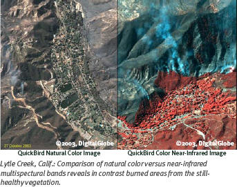
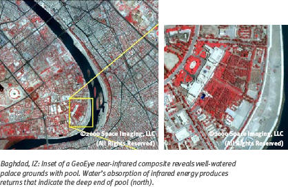
As an unclassified source, commercial imagery is used extensively when data sharing and interoperability are critical; this ability to share is an immensely valuable asset. Commercial imagery is available in many different resolutions, spectral bands, modes and accuracies, supporting a diverse array of defense, intelligence, federal, civil and coalition partners. Applications range from defense and military operations to disaster response and relief efforts.
NGA's commercial imagery strategy has three components:
- A focus on end-users of commercial imagery in the National System for Geospatial Intelligence (NSG) and the tools, training and infrastructure to support them
- An acquisition strategy that ensures access to all relevant commercial imagery sources across NGA's customer base
- Web services and tools to support ordering, ingesting, discovering, disseminating and exploiting commercial imagery across domains
In the first six months of 2007, the outreach staff of NGA's Commercial Remote Sensing (CRS) program briefed or attended more than 45 events. Outreach briefs, covering topics such as program overview, policy, licensing, capabilities, current architecture and discovery and dissemination tools, have reached over 1,000 end-users. In addition to traditional defense and intelligence customers, audiences included civil agencies such as the Bureau of Land Management, Forest Service, National Oceanic and Atmospheric Administration, U.S. Geological Survey and the Office of Surface Mining and many others. Demand has nearly doubled in the past year.
Commercial imagery representatives sit at various NGA and customer facilities to offer support on demand to commercial imagery users. NGA is also working to incorporate commercial imagery into its formal training programs.
Acquisition Strategy
Through its NextView program, NGA is monitoring the development of two commercial satellite systems to ensure the future availability of commercial imagery for customers. NGA guarantees the availability of high-resolution imagery from U.S. commercial satellites through contracts under this program. Both satellites are scheduled for launch this year. NGA also gathers satellite and airborne imagery from civil, foreign and other commercial sensors.
To ensure best value for its customers, NGA has negotiated broad licensing agreements that allow for the same image to be shared by users in the defense and intelligence communities. Dissemination statistics indicate that each image is used an average of 2.8 times.
Since 2000, NGA has acquired approximately 66 million square kilometers of high-resolution commercial satellite imagery. Given increasing demand, NGA projects that it will buy more than 69 million square kilometers in both fiscal 2008 and 2009.


Web Services and Tools
NGA's primary exploitation and production system, the Integrated Exploitation Capability, is being upgraded to provide analysts the ability to discover, retrieve and download commercial imagery. Already deployed to several sites, the upgrade allows commercial imagery to be delivered and exploited much like national sources.
Infrastructure modifications are under way to accommodate increases in data volume from future U.S. satellites and from the growing number of foreign satellites and commercial airborne sources. This will allow users to take full advantage of expanding capabilities and different types of commercial data.
NGA offers Web-based information management systems that provide the capability to capture customers' commercial imagery requirements, perform geospatial imagery research, order commercial imagery and download imagery on all networks.
A Look Ahead
NGA has made significant progress in its comprehensive commercial imagery strategy and is investing in its infrastructure to prepare for the future. Two major challenges to the successful accomplishment of this objective are the standardization of data and the dissemination of very large volumes and varieties of data. As the number and variety of sensors and the volume of data they generate increases, NGA must promote, develop and adopt standards that will allow for these to be efficiently ingested into the NSG.
NGA is actively pursuing transition of U.S. high-resolution commercial satellite imagery to the National Imagery Transmission Format (NITF) standard of the Department of Defense and Intelligence Community. Compliance with NITF 2.1 will provide enhanced imagery compression and metadata (information describing a dataset) and improve data flow. Because NGA's customer base is not only geographically dispersed, but spans a broad spectrum of infrastructures, the dissemination demands related to commercial imagery are equally complex.
Bolstered by the accomplishments to date, the CRS Program is committed to full-scale implementation of the comprehensive commercial imagery strategy that is so critical to NGA's mission to provide accurate, timely, meaningful GEOINT to its customers.