Ed. Note: This article first appeared in the
National Geospatial-Intelligence Agency's publication, Pathfinder, and
is reprinted here with permission.
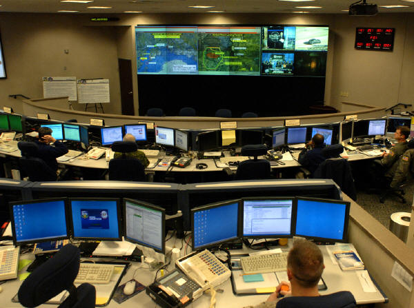
The U.S. Northern Command (NORTHCOM) has built a geographic information system (GIS) that could be crucial in the event of a chemical, biological, radiological, nuclear or high-yield explosive (CBRNE) event. The command, which stood up after the horrific terrorism of Sept. 11, 2001, has dual responsibilities for providing disaster assistance to civil authorities and preventing, deterring and defeating aggression against the United States.
Chartered to rapidly respond to a CBRNE event anywhere in the United States, its territories and possessions, NORTHCOM's Joint Task Force Civil Support (JTF-CS) developed the GIS with the help of NGA and other federal agencies.
NGA's Role
NGA's Homeland Security Infrastructure Program (HSIP) is the primary source of data populating the GIS. A geospatial analyst on site administers the Agency's support and keeps the HSIP data available for immediate deployment in support of the CBRNE mission. The analyst is of a member of the NORTHCOM NGA Support Team (NST).
The NORTHCOM NST provides tailored support to exercises and real-world operations on site as required through a combination of permanently assigned analysts and augmentees on temporary duty. These team members reach back to NGA's Office of Americas/North America and Homeland Security Divison and other NGA elements to obtain extensive indirect support.
The database of NORTHCOM's JTF-CS includes nationwide information on chemical industry and hazardous materiel facilities, nuclear power plants, first-responder and medical-services assets, and other critical infrastructure sectors and key asset categories. The system continues to develop and employ a robust set of GIS capabilities, including many commercial off-the-shelf and Web-based tools.
Predictive Capabilities
With its GIS capabilities, JTF-CS can obtain a comprehensive view of an operational environment prior to a CBRNE event occurring. These capabilities play a critical role in all aspects of pre-incident planning.
With information from the database, planners and responders have answers to key questions, such as the number and types of hospital beds available in an area; the location, types and quantities of toxic industrial chemicals stored in the area; the location of high-capacity venues; and the location of emergency shelters and emergency operations centers (EOCs).
This geospatial information can be used to provide the JTF-CS commander and his staff with a quick assessment of 'what if' scenarios involving the potential effects of a CBRNE event on a specific U.S. metropolitan area or region. With this understanding and knowledge, the JTF-CS commander and staff are able to quickly observe, orient, decide and act in response to a wide range of potential threats across the homeland.
Managing Consequences
In the unfortunate event of a CBRNE incident, GIS tools can be used to track and visualize an incident or hazard area in order to determine its potential impact on nearby population centers and infrastructure. For example, using the commercial package ArcGIS, analysts can rapidly display both manmade and natural incidents along with relevant data like population densities, first-responder assets, schools, medical facilities and lines of communication. The GIS displays give operational decision-makers a situational awareness of what has occurred, where it happened, and the extent of the affected area.
With a tool called the Consequence Management Interactive Mapping Service (CMIMS), the JTF-CS can deliver dynamic maps and CBRNE consequence-management data to higher headquarters, subordinate units and federal agency partners via the Web. Users can query, analyze and create a customized geospatial view with information based on their preferences.
NORTHCOM GIS analysts can quickly and seamlessly integrate analytical outputs from separate stand-alone ArcGIS systems and post them to the CMIMS. The Web site also enables vital information sharing among other DoD and federal consequence-management stakeholders.
If a CBRNE event occurs in the homeland, the GIS capabilities resident at JTF-CS will ensure that our nation's decision-makers have the right information at the right time in the right format to speed the government's response to the incident and mitigate its effects.
The U.S. Northern Command (NORTHCOM) has built a geographic information system (GIS) that could be crucial in the event of a chemical, biological, radiological, nuclear or high-yield explosive (CBRNE) event. The command, which stood up after the horrific terrorism of Sept. 11, 2001, has dual responsibilities for providing disaster assistance to civil authorities and preventing, deterring and defeating aggression against the United States.
Chartered to rapidly respond to a CBRNE event anywhere in the United States, its territories and possessions, NORTHCOM's Joint Task Force Civil Support (JTF-CS) developed the GIS with the help of NGA and other federal agencies.
NGA's Role
NGA's Homeland Security Infrastructure Program (HSIP) is the primary source of data populating the GIS. A geospatial analyst on site administers the Agency's support and keeps the HSIP data available for immediate deployment in support of the CBRNE mission. The analyst is of a member of the NORTHCOM NGA Support Team (NST).
The NORTHCOM NST provides tailored support to exercises and real-world operations on site as required through a combination of permanently assigned analysts and augmentees on temporary duty. These team members reach back to NGA's Office of Americas/North America and Homeland Security Divison and other NGA elements to obtain extensive indirect support.
The database of NORTHCOM's JTF-CS includes nationwide information on chemical industry and hazardous materiel facilities, nuclear power plants, first-responder and medical-services assets, and other critical infrastructure sectors and key asset categories. The system continues to develop and employ a robust set of GIS capabilities, including many commercial off-the-shelf and Web-based tools.
 |
Predictive Capabilities
With its GIS capabilities, JTF-CS can obtain a comprehensive view of an operational environment prior to a CBRNE event occurring. These capabilities play a critical role in all aspects of pre-incident planning.
With information from the database, planners and responders have answers to key questions, such as the number and types of hospital beds available in an area; the location, types and quantities of toxic industrial chemicals stored in the area; the location of high-capacity venues; and the location of emergency shelters and emergency operations centers (EOCs).
This geospatial information can be used to provide the JTF-CS commander and his staff with a quick assessment of 'what if' scenarios involving the potential effects of a CBRNE event on a specific U.S. metropolitan area or region. With this understanding and knowledge, the JTF-CS commander and staff are able to quickly observe, orient, decide and act in response to a wide range of potential threats across the homeland.
 |
Managing Consequences
In the unfortunate event of a CBRNE incident, GIS tools can be used to track and visualize an incident or hazard area in order to determine its potential impact on nearby population centers and infrastructure. For example, using the commercial package ArcGIS, analysts can rapidly display both manmade and natural incidents along with relevant data like population densities, first-responder assets, schools, medical facilities and lines of communication. The GIS displays give operational decision-makers a situational awareness of what has occurred, where it happened, and the extent of the affected area.
With a tool called the Consequence Management Interactive Mapping Service (CMIMS), the JTF-CS can deliver dynamic maps and CBRNE consequence-management data to higher headquarters, subordinate units and federal agency partners via the Web. Users can query, analyze and create a customized geospatial view with information based on their preferences.
NORTHCOM GIS analysts can quickly and seamlessly integrate analytical outputs from separate stand-alone ArcGIS systems and post them to the CMIMS. The Web site also enables vital information sharing among other DoD and federal consequence-management stakeholders.
If a CBRNE event occurs in the homeland, the GIS capabilities resident at JTF-CS will ensure that our nation's decision-makers have the right information at the right time in the right format to speed the government's response to the incident and mitigate its effects.
From Our Homepage
Saying Farewell to an Amazing Journey
Communicating with Maps
Is There a GIS Career Ladder?
What does it mean to be geospatially smart? Series
Ways Real Estate and Property Developers Utilize Melissa GeoData for Data-Driven Decisions
Unlocking Value From Daily Satellite Imagery and Insights
Maximizing the Value of Your Address Data with Geo Addressing
How Indoor Mapping Enhances the Security of Smart Buildings
Look Ahead: AI, Location Intelligence and Efficiency
Collaboration Takes on Sea Level Rise & Dynamic Technology Environments
Brownies for Brownfields
Has Everything Been Mapped Already?
How Is Data Literacy Changing in an Artificial Intelligence Landscape
Portfolios for GIS Professionals: More Than Just Maps
How to Create a Distance Matrix in QGIS - A Step-by-Step Guide
7 Ideas for Bringing GIS into the K-12 Classroom
The Geography of Movement