Geographic space is the environment around us and the greater world in which we live.We can directly experience many things in geographic space, but the scale is such that we cannot experience then all at once.Maps are powerful graphic tools that classify, represent and communicate spatial relations.Therefore, cartographic maps have been used for centuries as a method to communicate the spatial information between cartographer and map users, through visualizing geographical distributions across a world that is too large and too complex to be seen directly.The widespread use of computer systems drives the map in the move away from static maps to interactive, dynamic and animated geographic visualizations that can be designed by anyone with access to software and data.The use of such map media in the sense of perception of the information contained in them depends primarily on the linguistic competence of the users.Otherwise, during the selection and arrangement of the visual elements that produces meaning, much useful information about the real world has to be omitted due to the limitations of the 2D map space, and the introduction of some noise.The intrinsic obscure tendency of map metaphor based information encoding and decoding in lower dimensions of space misdirects the communication between information and humans.
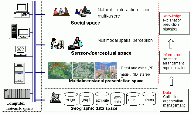
A Virtual Geographic Environment (VGEs) is a virtual representation of the natural world that enables a person to explore and interact, in cyberspace, with the vast amounts of natural and cultural information gathered about the physical and cultural environment.Compared with the data-centered GIS, VGE is defined as a human-centered environment.The VGE consists of the five types of space: network spaces, geographic data spaces, multidimensional presentation spaces, sensory/perceptual spaces and social spaces.These spaces make VGE quite different from the traditional virtual reality space associated with unrealistic expectations. VGE is equated with reality by making the spaces continuous and coextensive.
Click image for larger
view.
Geospatial information is quite different from other kinds of information, for its unique properties of territorial, multidimensional structural and dynamic change.Therefore, the multidimensional and dynamic analysis methods become the fundamental approaches for exploring spatial problems from all dimensions.Since VGE possesses full multidimensional space, almost all kinds of information may be embedded, without channel limitations or loss of information.Herein, the dimensions related to VGE mean not only the traditional (X, Y, Z) orthogonal spatial dimensions, but also other non-spatial dimensions, i.e.the thematic and temporal dimensions, such as shadow, color, material, force and sound. Whatever we are discussing: 1D speech or text, 2D map, 2.5D DTM (digital terrain model), 3D GIS, 4D animation, or xD thematic attributes, each has its own relative advantages and disadvantages in spatial expression and conception; each dimension is suitable to a specific representation of reality.Due to media limitations, N-dimensional space is always represented in lower dimensional space such as 2D-3D through the dimensionality reduction and typical aggregation of information.Unusual knowledge therefore can be easily discovered.The utility of VGE enables the abstract phenomena to be more actual and intuitive, and then facilitate the spatial decision-making support, such as exploration, explanation, prediction and planning.
Whilst VGE space is three dimensional, the representation is not limited to three dimensions.If the spatial information were limited in one or two kinds of representations, it would be inaccurate or misleading as a tool to understand the environment, making simple phenomena become more complex.It is clear that user-centered VGE offer a more ergonomic platform for humans to manage basic and high-level cognitive tasks in everyday life.When moving from 2D to 3D, even though only one dimension is extended, there are many more possible choices for the representation of spatial information.This facilitates further exploratory analysis and helps us to gain real insights into the problem at hand.The visual presentation is of primary importance; the spatial representations extend beyond the visual.It appears that auditory representations provide the best options for constructing an augmented virtual environment.Speech provides a viable alternative for many applications in which spatial data must be presented non-visually, particularly those requiring mobility.
VGE is firstly expected as the topmost human-computer interface for geographic information communication and is definitely related to certain adopted devices or intermedia.The interface technologies include visual, auditory, tracking, primary user input and haptic interfaces, which offer a more intuitive metaphor for human-computer interaction and are widely used in virtual environments. VGE is therefore designed to provide the interaction with a virtual environment in the same way that interaction takes place in the natural world.Because of the multi-sensory perceptual capability, the human-computer communication channel is broadened and we can take advantage of unused 'bandwidth' for more flexible spatial information communication during the collaborative design procedure.
As the topmost geographic
information communication tool and human-computer interface, the VGEs provide
the augmentation of sensory reality, and open up new ways for us to comprehend
the real world, as well as the AEC and the GIS worlds.VGEs provide multidimensional
and multisensory user-interfaces, intended to facilitate both browsing
of the multidimensional dataset and further specific exploration within
the same visualization context.Therefore the two distinct areas of AEC
and GIS are seamlessly merged in the same VGEs.