 After
wresting its independence from the former Union of Soviet
Socialist Republics (USSR) in 1991,
Lithuania
underwent a series of significant changes in its governmental structure
and
direction.One involved the development of laws to restore land
ownership, and
organize a system to manage real property, which helps
re-establish
confidence in a country's ownership rights and business environment.
After
wresting its independence from the former Union of Soviet
Socialist Republics (USSR) in 1991,
Lithuania
underwent a series of significant changes in its governmental structure
and
direction.One involved the development of laws to restore land
ownership, and
organize a system to manage real property, which helps
re-establish
confidence in a country's ownership rights and business environment.
After initial attempts to use existing legal information and topographical maps as a basis to develop a cadastral system to support its land ownership program, it was decided that historic survey and data errors were being perpetuated from the old system to the new one.Lithuania's State Land Cadastre Enterprise (SLCE) then formed a special GIS committee to examine the current mapping technology with the directive to implement a digitally based cadastral system in Lithuania.
In 1995, through a special Denmark-Lithuania land survey project and the PHARE program, set up by the European Union (EU) to assist applicant nations in joining its organization, Lithuania's State Land Surveying Institute (SLSI) implemented a cadastral mapping production system based on ESRI software.
 Later, the State Enterprise
Centre
of Register (SECR) was established and tasked with integrating all
real estate
records and cadastre data into a single, GIS-based, system.Data from
the land
register as well as data on buildings, constructions, premises, and
apartments
were subsequently integrated into the Real
Property Information System (RPIS).Legal,
technical, and geographical records have also been integrated into the
system.
Later, the State Enterprise
Centre
of Register (SECR) was established and tasked with integrating all
real estate
records and cadastre data into a single, GIS-based, system.Data from
the land
register as well as data on buildings, constructions, premises, and
apartments
were subsequently integrated into the Real
Property Information System (RPIS).Legal,
technical, and geographical records have also been integrated into the
system.
The SECR's GIS department uses ArcGIS to administer the central database, integrate data with attributes, and provide maps on the Internet.Thirty-three layers of data are maintained with ArcSDE, including administrative boundaries, buildings' center points, address points, real property value zones, topographic objects, land use, standard map sheets, and orthophoto maps.
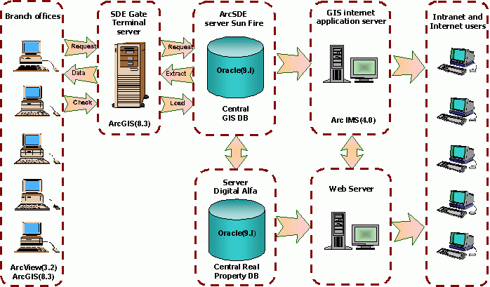
System architecture.Click image for larger view.
The SECR also performs appraisals
of real property.This valuation system strengthens real estate markets
and
supports value-based taxation.GIS is an important component of its
Mass
Appraisal System.By accessing parcel, register, and market information
from a
single database, the appraisal system is used to compute mass-values
for
property located in territories based on prescribed principles within a
defined
time using updated market data.It also allows for periodic
re-evaluation of
property values in response to market changes.
Lithuanian taxes on property includes land tax, which is applied to the value of both urban and rural private land, and real property tax, which is applied to the value of real estate (excluding land).The base value for land tax properties depends on the land's productivity point and is adjusted for factors including urban-ecological conditions, availability of engineering facilities, and so forth.Real property taxable value is equal to replacement cost adjusted by locality coefficients.
Land parcel data are grouped by characteristics essential to land market value, such as value zones, purpose of use, agricultural land, size of the land parcel, productivity grade, and recreational use.These valuations are displayed on a map and the user can access further information in the database through the map or through textual query.
The SECR's GIS facilitates the inclusion of many factors in its data model.Tax formulas can be automatically applied and computed.The system is easily updated to reflect market dynamics and owner discrepancies.Quality control is ensured by comparison of sales costs and appropriate values.Because GIS is database driven, it can facilitate the development of a tax model that can be used to calculate tax liability related to property values.The model can be easily updated to reflect current tax fees and laws.
Presently, the GIS department is implementing a new application called SDEGATE for its Real Property Cadastre and Register (RPCR) central database.The application works by extracting a copy of the data in an area of interest from the central database through ArcSDE, locking this area while editing or reviewing, and committing it back to the central database.For example, an end user in one of the branch offices can define an area of interest by inputting a polygon representing this area into SDEGATE.SDEGATE checks to see if another user doing geodata updating has locked this area.If this area is unlocked SDEGATE connects to ArcSDE, extracts the data, sends the data to the user, then disconnects from the database and puts a write lock on the area by identifying the area in a special table within the database.No other user can edit those extracted features until the data is committed back to the database.When the end user has made all necessary edits and committed the data back, SDEGATE performs a check of the data upon committing updates to the database and unlocks the area of interest.At any time, an end user can get information about which ArcSDE areas are being edited from any of the GIS computer stations.
The SECR has also developed an application for the delivery of cadastral maps integrated with its RPCR via the Internet, using ArcIMS technology.A user can get a variety of information about a property including an orthophoto map, administrative boundaries, the boundaries of cadastral units and blocks, land parcels, value zones, center lines of streets, and so on all from his own computer.
From Our Homepage
Saying Farewell to an Amazing Journey
Communicating with Maps
Is There a GIS Career Ladder?
What does it mean to be geospatially smart? Series
Ways Real Estate and Property Developers Utilize Melissa GeoData for Data-Driven Decisions
Unlocking Value From Daily Satellite Imagery and Insights
Maximizing the Value of Your Address Data with Geo Addressing
How Indoor Mapping Enhances the Security of Smart Buildings
Look Ahead: AI, Location Intelligence and Efficiency
Collaboration Takes on Sea Level Rise & Dynamic Technology Environments
Brownies for Brownfields
Has Everything Been Mapped Already?
How Is Data Literacy Changing in an Artificial Intelligence Landscape
Portfolios for GIS Professionals: More Than Just Maps
How to Create a Distance Matrix in QGIS - A Step-by-Step Guide
7 Ideas for Bringing GIS into the K-12 Classroom
The Geography of Movement