I made it a point this year in my one pass through the
exhibit hall to speak to companies with which I was not familiar. I
found a bumper crop of small companies with unique ideas about how to
use the cloud, build out 3D models for free, and really communicate 3D
information.
Arc2Earth
I knew of the app Arc2Earth, used by many to move ESRI data into a form for use in Google mapping apps and Virtual Earth. And I knew of Brian Flood, the fellow behind the software, from the blogosphere. I'd even read the news about how Arc2Earth was moving to the cloud. However, I didn't fully appreciate what that meant until I spoke to Flood in his booth.
The implementation is a whole solution for uploading geodata (assuming you have a copy of Arc2Earth), hosting those data and allowing manipulation of those data (think editing, basic geoqueries), etc. This is a solution for those who don't want to host locally, who want to do editing in the cloud and want to take advantage of Google Maps/Earth, Virtual Earth or OpenLayers as a backdrop for their data. Further, "renting" the services can be far cheaper than buying software, supporting an implementation, and hosting that implementation locally. This is still a work in progress, due to be available in 2009 and I'm glad: I'm still wrapping my brain around it, and its implications. Flood and his colleagues are still finalizing details, mostly in the pricing arena. Keep an eye on this solution; it's a very different way of dealing with data sharing/management challenges, as well as the love many users have for Google's and Microsoft's environments.
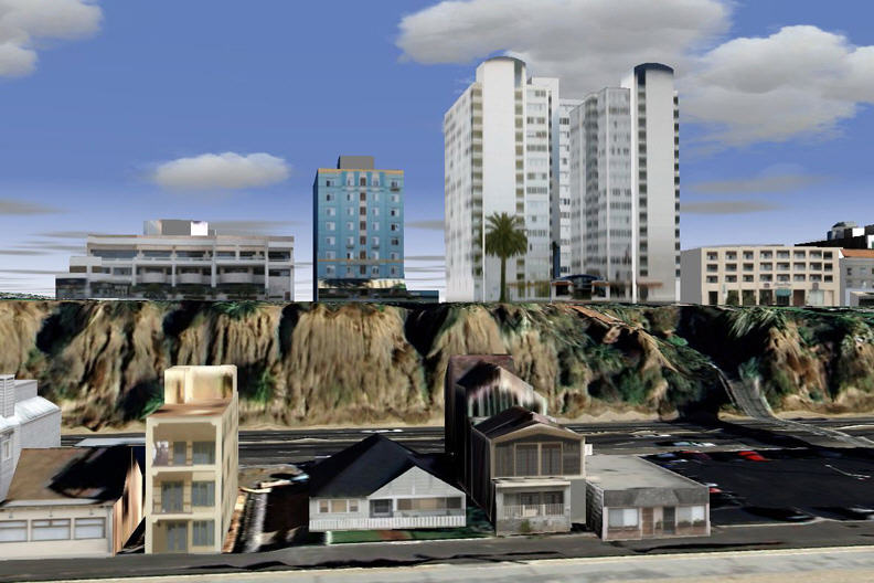
CyberCity 3D
Do you want a FREE 3D model of part of your city? I know how you can get it! Government agencies and consortia can "donate" appropriate stereo data to CyberCity 3D and get a sample developed into a full 3D model, in a choice of formats (multipatch, geodatabase, shapefile, DXF, 3DS, WRL). CyberCity 3D will create the full model and offer it for sale to others (that's how they can offer it for free). They'll also donate the model to Google, so your city will "pop up" in 3D. The company has its own nearly 100% automated process to create the models. The bottom line, explained to me by the CTO, is that if the data meet CyberCity 3D requirements, the model will retain the same accuracy in 3D. (6" in the stereo pair => 6" in the model.) CyberCity 3D has made models for Washington DC, Seattle, Portland, Santa Monica and others. Some who take the company up on the "freebie" deal eventually pay for the entire city. This is an interesting data model; it's another to watch and perhaps test out with the Data Exchange Program. CyberCity 3D's booth was strategically placed next to Google's!
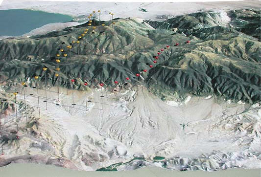
Solid Terrain Modeling
The most popular corner of the ESRI conference exhibit a few years ago included the Touch Table. Another year it was the Terrain Table. These interactive "technology map tables" struck a chord with this mapping crowd. I was pleased this year to see many people touching, watching and generally enjoying a static 3D model of terrain in the Solid Terrain Modeling booth. The map "layers" were projected on top-like slides.
I asked the "stupid" question: "Why are we drawn to this, and why do we understand this so differently than, say, flying in Google Earth?" I asked the right person, founder and president Lawrence Faulkner. He had a theory that our brains are designed to capture spatial information that doesn't move; that allows us to create meaningful context and "learn more." He cited a court case involving a plane crash. The jury was shown a short simulation video for 90 seconds. Then, the defense used a 3D model with "pins" noting locations of key elements to "tell the story." The jury asked to have the model while they deliberated; they never asked to see the video again. He also noted that soldiers who use full immersion video for training are often "messed up" spatially for a few days afterward. Clearly, these 3D models, perhaps like the actual landscape, have a special way of communicating with humans. The U.S. military likes the models so much it acquired its own manufacturing machine (basically a giant map carving machine) from the company to create its own models! Other users of the models include the U.S. Park Service and National Geographic (which has some bronze ones), among others.
Arc2Earth
I knew of the app Arc2Earth, used by many to move ESRI data into a form for use in Google mapping apps and Virtual Earth. And I knew of Brian Flood, the fellow behind the software, from the blogosphere. I'd even read the news about how Arc2Earth was moving to the cloud. However, I didn't fully appreciate what that meant until I spoke to Flood in his booth.
The implementation is a whole solution for uploading geodata (assuming you have a copy of Arc2Earth), hosting those data and allowing manipulation of those data (think editing, basic geoqueries), etc. This is a solution for those who don't want to host locally, who want to do editing in the cloud and want to take advantage of Google Maps/Earth, Virtual Earth or OpenLayers as a backdrop for their data. Further, "renting" the services can be far cheaper than buying software, supporting an implementation, and hosting that implementation locally. This is still a work in progress, due to be available in 2009 and I'm glad: I'm still wrapping my brain around it, and its implications. Flood and his colleagues are still finalizing details, mostly in the pricing arena. Keep an eye on this solution; it's a very different way of dealing with data sharing/management challenges, as well as the love many users have for Google's and Microsoft's environments.
CyberCity 3D
Do you want a FREE 3D model of part of your city? I know how you can get it! Government agencies and consortia can "donate" appropriate stereo data to CyberCity 3D and get a sample developed into a full 3D model, in a choice of formats (multipatch, geodatabase, shapefile, DXF, 3DS, WRL). CyberCity 3D will create the full model and offer it for sale to others (that's how they can offer it for free). They'll also donate the model to Google, so your city will "pop up" in 3D. The company has its own nearly 100% automated process to create the models. The bottom line, explained to me by the CTO, is that if the data meet CyberCity 3D requirements, the model will retain the same accuracy in 3D. (6" in the stereo pair => 6" in the model.) CyberCity 3D has made models for Washington DC, Seattle, Portland, Santa Monica and others. Some who take the company up on the "freebie" deal eventually pay for the entire city. This is an interesting data model; it's another to watch and perhaps test out with the Data Exchange Program. CyberCity 3D's booth was strategically placed next to Google's!
 |
The most popular corner of the ESRI conference exhibit a few years ago included the Touch Table. Another year it was the Terrain Table. These interactive "technology map tables" struck a chord with this mapping crowd. I was pleased this year to see many people touching, watching and generally enjoying a static 3D model of terrain in the Solid Terrain Modeling booth. The map "layers" were projected on top-like slides.
I asked the "stupid" question: "Why are we drawn to this, and why do we understand this so differently than, say, flying in Google Earth?" I asked the right person, founder and president Lawrence Faulkner. He had a theory that our brains are designed to capture spatial information that doesn't move; that allows us to create meaningful context and "learn more." He cited a court case involving a plane crash. The jury was shown a short simulation video for 90 seconds. Then, the defense used a 3D model with "pins" noting locations of key elements to "tell the story." The jury asked to have the model while they deliberated; they never asked to see the video again. He also noted that soldiers who use full immersion video for training are often "messed up" spatially for a few days afterward. Clearly, these 3D models, perhaps like the actual landscape, have a special way of communicating with humans. The U.S. military likes the models so much it acquired its own manufacturing machine (basically a giant map carving machine) from the company to create its own models! Other users of the models include the U.S. Park Service and National Geographic (which has some bronze ones), among others.
 |
From Our Homepage
Saying Farewell to an Amazing Journey
Communicating with Maps
Is There a GIS Career Ladder?
What does it mean to be geospatially smart? Series
Ways Real Estate and Property Developers Utilize Melissa GeoData for Data-Driven Decisions
Unlocking Value From Daily Satellite Imagery and Insights
Maximizing the Value of Your Address Data with Geo Addressing
How Indoor Mapping Enhances the Security of Smart Buildings
Look Ahead: AI, Location Intelligence and Efficiency
Collaboration Takes on Sea Level Rise & Dynamic Technology Environments
Brownies for Brownfields
Has Everything Been Mapped Already?
How Is Data Literacy Changing in an Artificial Intelligence Landscape
Portfolios for GIS Professionals: More Than Just Maps
How to Create a Distance Matrix in QGIS - A Step-by-Step Guide
7 Ideas for Bringing GIS into the K-12 Classroom
The Geography of Movement