Exploration software and GIS are essential for
geologists searching for petroleum and mineral deposits. With
discoveries harder to find, geoscientists are collecting more data than
ever before and examining their findings with greater scrutiny. The key
to keeping the whole process efficient and focused is technology.
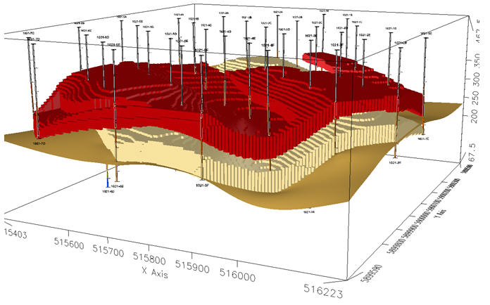
Earth mapping software has come a long way in the past 10 years, providing more advanced three dimensional tools to visualize and create sophisticated models of the subsurface. Exploration software developers like Canada-based Geosoft have focused on fine tuning workflows and algorithms for handling large geological, geophysical and geochemical earth data. Geoscientists working within the mining and petroleum industries rely on these powerful algorithms to piece together their understanding of the subsurface and develop their exploration projects. But until recently, the inability to work and share data between earth mapping platforms like Geosoft and ESRI's ArcGIS environments had left a gap for explorers. As software developers on both sides of the gap begin to collaborate, technology and solutions are now evolving to allow geoscientists to share data between their mapping and GIS environments.
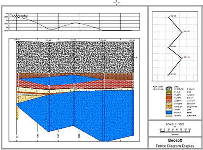
GIS software has been used for 2D mapping for decades. However, the limited ability of GIS to visualize below the earth's surface meant exploration companies have had to resort to work-arounds. As a result, geoscientists tend to store their geological, geophysical and geochemical information in one database, and their surface geospatial data in another, with no efficient way of merging the two.
Although geoscientific data can be moved in and out of a GIS environment, doing so is time-consuming and can result in lost, changed or corrupted data. For consulting geophysicists like Michal Ruder, whose livelihood depends on delivering accurate, up-to-date maps to clients in the oil and gas sector, recent advances in integrated GIS exploration tools mean smoother workflow and higher productivity in both 2D and 3D environments.
"Most of the time I work with gridded data, and I can manipulate it using Geosoft exploration software," said Ruder, who is principal of Denver-based Wintermoon Geotechnologies. "That's not the whole solution, though, because after I've processed the gridded data, I need to integrate it with vector data. That means putting my magnetic and gravity data into the geographic context of my exploration problem."
After moving the data into ESRI's ArcGIS, Ruder uses Geosoft extension software, Target for ArcGIS, to see geographic and other associations. She then searches for patterns in the Geosoft grids and ArcGIS vector data. Geosoft is working to close the exploration GIS gap entirely with its recent introduction of earth mapping software that has ArcGIS Engine technologies built in. The new generation of Geosoft mapping software allows geoscientists to work seamlessly between their Geosoft and ESRI environments using ESRI technology to display Arc.mxd and .lyr files without leaving the Geosoft environment.
The breakthrough is expected to boost productivity and result in smoother workflows for geoscientists in both the private and public sectors. It will also prevent data from being changed or lost. "With this software, geoscientists have greater flexibility and control in achieving the results they need," said Louis Racic, director of product management for Geosoft Inc.
Closing the gap between GIS and geoscience also benefits large
companies with multiple users and data sets. The more integrated their
exploration software is, the less is the likelihood of costly mistakes
or missed opportunities for discovery. Ana Maria Gonçalves is
information manager for the exploration and project development
division of Brazil-based Companhia Vale do Rio Doce (Vale), one of the
largest mining companies in the world with 14 regional exploration
offices. "As we become more global, being able to share information and
expertise with other regions is increasingly important," said
Gonçalves. "In the past, our exploration applications didn't
connect with our GIS. We had to make all sorts of conversions, and with
data sets such as geophysical grids, you can lose important information
when you try to convert the data to other formats."
Adopting Geosoft Target for ArcGIS has done away with the need for data conversion, said Gonçalves. "Using Target for ArcGIS, our geoscientists can work with their geophysical, geochemical and geological data within the ArcGIS environment much more quickly and effectively."
On a broader scale, trends in mineral exploration show there's a need for better integration of GIS and geosciences. Most ore deposits with a surface expression have already been found, so 3D information from the subsurface - particularly geophysical data - is becoming the main pathfinder to discoveries.
Earth mapping software has come a long way in the past 10 years, providing more advanced three dimensional tools to visualize and create sophisticated models of the subsurface. Exploration software developers like Canada-based Geosoft have focused on fine tuning workflows and algorithms for handling large geological, geophysical and geochemical earth data. Geoscientists working within the mining and petroleum industries rely on these powerful algorithms to piece together their understanding of the subsurface and develop their exploration projects. But until recently, the inability to work and share data between earth mapping platforms like Geosoft and ESRI's ArcGIS environments had left a gap for explorers. As software developers on both sides of the gap begin to collaborate, technology and solutions are now evolving to allow geoscientists to share data between their mapping and GIS environments.
 |
GIS software has been used for 2D mapping for decades. However, the limited ability of GIS to visualize below the earth's surface meant exploration companies have had to resort to work-arounds. As a result, geoscientists tend to store their geological, geophysical and geochemical information in one database, and their surface geospatial data in another, with no efficient way of merging the two.
Although geoscientific data can be moved in and out of a GIS environment, doing so is time-consuming and can result in lost, changed or corrupted data. For consulting geophysicists like Michal Ruder, whose livelihood depends on delivering accurate, up-to-date maps to clients in the oil and gas sector, recent advances in integrated GIS exploration tools mean smoother workflow and higher productivity in both 2D and 3D environments.
"Most of the time I work with gridded data, and I can manipulate it using Geosoft exploration software," said Ruder, who is principal of Denver-based Wintermoon Geotechnologies. "That's not the whole solution, though, because after I've processed the gridded data, I need to integrate it with vector data. That means putting my magnetic and gravity data into the geographic context of my exploration problem."
After moving the data into ESRI's ArcGIS, Ruder uses Geosoft extension software, Target for ArcGIS, to see geographic and other associations. She then searches for patterns in the Geosoft grids and ArcGIS vector data. Geosoft is working to close the exploration GIS gap entirely with its recent introduction of earth mapping software that has ArcGIS Engine technologies built in. The new generation of Geosoft mapping software allows geoscientists to work seamlessly between their Geosoft and ESRI environments using ESRI technology to display Arc.mxd and .lyr files without leaving the Geosoft environment.
 |
The breakthrough is expected to boost productivity and result in smoother workflows for geoscientists in both the private and public sectors. It will also prevent data from being changed or lost. "With this software, geoscientists have greater flexibility and control in achieving the results they need," said Louis Racic, director of product management for Geosoft Inc.
 |
Adopting Geosoft Target for ArcGIS has done away with the need for data conversion, said Gonçalves. "Using Target for ArcGIS, our geoscientists can work with their geophysical, geochemical and geological data within the ArcGIS environment much more quickly and effectively."
On a broader scale, trends in mineral exploration show there's a need for better integration of GIS and geosciences. Most ore deposits with a surface expression have already been found, so 3D information from the subsurface - particularly geophysical data - is becoming the main pathfinder to discoveries.
From Our Homepage
Saying Farewell to an Amazing Journey
Communicating with Maps
Is There a GIS Career Ladder?
What does it mean to be geospatially smart? Series
Ways Real Estate and Property Developers Utilize Melissa GeoData for Data-Driven Decisions
Unlocking Value From Daily Satellite Imagery and Insights
Maximizing the Value of Your Address Data with Geo Addressing
How Indoor Mapping Enhances the Security of Smart Buildings
Look Ahead: AI, Location Intelligence and Efficiency
Collaboration Takes on Sea Level Rise & Dynamic Technology Environments
Brownies for Brownfields
Has Everything Been Mapped Already?
How Is Data Literacy Changing in an Artificial Intelligence Landscape
Portfolios for GIS Professionals: More Than Just Maps
How to Create a Distance Matrix in QGIS - A Step-by-Step Guide
7 Ideas for Bringing GIS into the K-12 Classroom
The Geography of Movement