Although information technology is not a center-stage
strategy in exploration industries grappling with economic and market
uncertainties, it remains a key driver for improving effectiveness and
results - particularly when you consider the growing data requirements
of modern day exploration.
Explorers continue to raise the bar for the software experience and capabilities they expect, from full 3D visualization to data processing power under the hood and advanced integration support for multidisciplinary datasets. Furthermore, many exploration organizations are setting stronger corporate standards for the software they use on their exploration projects, and how they use and manage their growing digital data resources.
During lean times, data-related waste and inefficiency - whether it is resources spent looking for the right data, hours wasted converting incompatible data products, or money lost through faulty decision making - are an easy target for improving productivity and results. The fact that there are solutions for making many, if not all, of these data issues simply go away is reason enough to rethink your software choices and technology strategy.
Two important recent developments in exploration technology have been the delivery of stronger spatial data access and management capabilities through the Internet, and advanced workflow support within GIS, which has become a standard spatial platform for integrating and analyzing geospatial data with geology and other exploration datasets.
Both are helping explorers to work faster and smarter; to easily share data and knowledge across teams, departments and regional boundaries; and to manage and make sense of larger amounts of digital data for exploration decision making.
Spatial Data Access and Management
Over the past 15 years, governments and educational institutions have been making vast amounts of data available on the Internet. There are hundreds of data resources and millions of spatial data sets available - including geophysical, geochemical, satellite images and magnetic data - published by government and private organizations through open Web-based services. Most exploration companies also have large, internal data resources typically stored in a variety of different systems. However, today's fractured data landscape doesn't make the process of data discovery easy, natural or seamless in either environment.
A major challenge is that each data resource, whether internal or online, has its own interface for finding and accessing the data. And often you need to go through numerous steps to find the data and then applications to convert them into a usable, consistent form before you can even begin the actual exploration process.
Newer technologies, such as spatial search, server and desktop cataloguing applications, are revolutionizing how explorers find and manage their data and information.
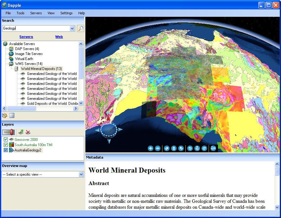
In recent years, exploration software developer Geosoft has continued to expand the range of its exploration information management capabilities. The company has built its solutions around its core DAP (Data Access Protocol) server, Dapple globe viewer and DappleSearch technologies.
"We wanted to provide explorers with a simple way to find data that match their area of interest and the ability to view these data in a visual and meaningful way," said Ian MacLeod, Geosoft chief technologist. "Together, Dapple and DappleSearch provide fast spatial and text search, and show results as thumbnails with full metadata. Explorers are then a click away from displaying data in Dapple."
Geosoft's DappleSearch is a spatial catalogue Web service that creates and maintains a database of active and verified Internet servers that host spatial data services. Just as regular Internet users rely on Google to keep track of the near-limitless resources available online, earth explorers can use DappleSearch to keep track of new spatial data services as they become available.
The Web crawler continually searches new URLs to update the catalogue. To date, the catalogue engine has visited more than one million data layers over the Internet, of which about 200,000 have been accepted into the catalogue index. Periodic re-testing of all indexed services drives the search engine's relevancy.
As Dapple users themselves discover new service sites, the URLs of the service sites are also reported to DappleSearch, which adds each URL to a list of candidates to be considered for the shared catalogue.
What does it all mean for the explorer? Managing exploration data resources, for easy access and maximum reliability, is a key advantage during all phases of a project lifecycle. During early stage exploration, the two or three months previously spent pulling together project data can be reduced to days through the effective leveraging of existing resources and technology enablers. Explorers can make go/no-go decisions more quickly, based on richer information - which means better decisions. These benefits continue once the work is underway.
"Once all the preliminary work is done, explorers are constantly updating their information by collecting and interpreting new data from the field and integrating the results back into their original data sets," says Steve Randall, director of Product Management with Geosoft. "Spatial cataloguing, search and viewer technologies enable easy access and integration of new data as soon as they are available. This means explorers can always be in sync with their data no matter what systems they are using, or when or where they are being accessed. This wasn't the case previously, which often led to delays and inconsistencies in managing the project."
And since time is of the essence, performance and response rate are critical, especially as datasets continue to grow and threaten to degrade system and network performance.
"Explorers need cause and effect to happen instantly, right in front of them," says MacLeod. "We're able to handle absolutely massive catalogues, and from the end user's perspective it's an instantaneous response. We'll continue to spend research and development effort to make sure the technology is as responsive as it can be."
"All of this has huge workflow implications," says Randall. "From finding all the relevant data sources, evaluating them and extracting them back into your interpretation environment, there's so much flexibility that didn't exist even two or three years ago."
Better preparation is also an effective way to maintain competitive advantage. "These technologies can't guarantee you better success rates, but they can guarantee you more time to help you evaluate your decisions," he says. "You can be more effective and productive, which will in turn probably lead to greater success."
Exploration Workflows in GIS
Though GIS has always had a role to play in the search for mineral deposits, adoption of GIS in the exploration industry has grown for several reasons. Not the least of these is the fact that there are more tools available to help explorers effectively work within the GIS environment - conducting advanced geospatial analysis and creating accurate, quality results.
The questions posed by resource exploration and the answers offered by GIS are a natural fit. Exploration teams need to integrate and make sense of reams of geochemical and geological information in order to find ore bodies. GIS supports this complex workflow by managing and analyzing the data and displaying them in a spatial context.
As GIS becomes more mainstream in all aspects of life - from the ever changing political wall maps used by CNN to depict U.S. election results, to Google Map applications that can track a runner's training routes - geoscientists are becoming more comfortable weaving geospatial technology into their workday. The real breakthrough, however, has been adding and improving exploration workflow support for geologists and specialists working with large and multidisciplinary exploration datasets.
"I think one of the most critical aspects in the recent uptake is direct workflow support," says Geoff Wade, ESRI's Natural Resource Industries manager. "But to support the most complex of specialist workflows, GIS really needs to be in the hands of a specialist solution builder. Our global partnership with Geosoft has been essential to fulfilling the specific needs of explorers working within ArcGIS."
In collaboration with ESRI, Geosoft has been building next generation GIS solutions for exploration industries and the geosciences sector.
"We identified several explorer challenges, from basic format incompatibility issues, to a lack of advanced tools for visualizing and interpreting earth datasets (geology, geochemistry and geophysics) inside GIS systems," said Louis Racic, Geosoft's director of Desktop Applications. "And we set out to create a whole solution for explorers that would bridge these gaps."
From an interoperability standpoint, Geosoft has made it a development priority to support all of the leading GIS data formats, and other common data formats, says Racic. "There is nothing more frustrating than spending time fiddling with incompatible data formats. Our goal is to eliminate the need to convert data formats entirely, and free up time for the exploration team to collaborate in an integrated environment."
Geosoft chose to extend its exploration workflows to the ESRI ArcGIS environment to meet customer demand for simpler and more seamless solutions that meet their exploration project needs.
"ESRI technology easily scales to the growing data and spatial challenges that exploration organizations are facing," said Racic. "And we've also seen strong adoption of ArcGIS within global, government geological surveys and the academic geoscience sector."
One result has been strong market demand for Geosoft ArcGIS exploration workflow solutions. "Our Target for ArcGIS extension software was our highest growth product last year, and we were taking orders for the new Geochemistry for ArcGIS before its release to market," said Racic. "We're seeing strong interest in the Geochemistry extension from the government sector as well as the exploration industry."
Geosoft has advanced its exploration strategy in GIS with the recent release of a Geochemistry for ArcGIS extension that extends the explorer's toolkit by providing the ability to analyze geochemical data within the ArcGIS environment, according to Racic. And it provides a powerful exploration workflow solution that's not currently available in the market.
Geochemical investigations require the ability to process and analyze all components of geochemical sampling in context with the geology and geophysics. With the tools available within Geochemistry for ArcGIS, explorers can effectively extract knowledge from their data by examining multivariate relationships, uncovering underlying structures and identifying outliers and anomalies, and then present results by easily creating informative, visually impactful maps.
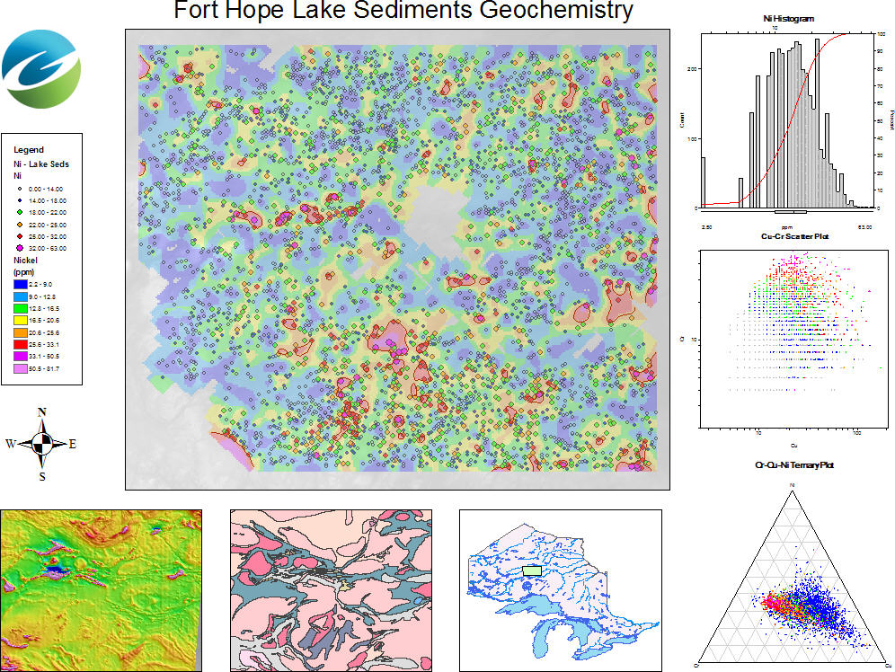
Using Geochemistry for ArcGIS, explorers can simplify their geochemistry quality control process and maintain data in an ESRI file geodatabase using a data model optimized for geochemical data. They can select and subset data interactively from maps based on lithology and regions to enhance data display; create advanced geochemical maps within the ESRI ArcGIS Desktop environment; and analyze multi-element geochemistry using a variety of tools. These tools include interactive multiple histogram plots, Pearson's correlation reports, scatter plots, probability plots, ternary plots and box plots to identify outliers and define populations.
Wade recommends a gradual adoption of GIS by the exploration department, but one that is incorporated by every member of the interdisciplinary team.
"We find it particularly effective if several members of the project team embrace the technology at the same time, thereby supporting each other in the education process and gaining extra benefit from data sharing, improved workflow support and an improved communication capability," he says.
In addition to workflow support, effective integration of GIS within your exploration organization is also an important consideration. "Technology aside, if you start with a good understanding of your people's data requirements and project workflows, then you are more likely to achieve the results you need," says Racic.
There is no doubt that explorers today, both junior and major, are operating in a rapidly changing exploration environment that is increasingly reliant on data and applications available through the Internet. There's more digital data to makes sense of, greater integration and interpretation challenges and larger drilling projects to manage. For many, the choice is clear: retool to deal with the new complexities of exploration and take advantage of all the rich, digital data and applications coming online, or risk being left behind, and missing out on future opportunities.
Explorers continue to raise the bar for the software experience and capabilities they expect, from full 3D visualization to data processing power under the hood and advanced integration support for multidisciplinary datasets. Furthermore, many exploration organizations are setting stronger corporate standards for the software they use on their exploration projects, and how they use and manage their growing digital data resources.
During lean times, data-related waste and inefficiency - whether it is resources spent looking for the right data, hours wasted converting incompatible data products, or money lost through faulty decision making - are an easy target for improving productivity and results. The fact that there are solutions for making many, if not all, of these data issues simply go away is reason enough to rethink your software choices and technology strategy.
Two important recent developments in exploration technology have been the delivery of stronger spatial data access and management capabilities through the Internet, and advanced workflow support within GIS, which has become a standard spatial platform for integrating and analyzing geospatial data with geology and other exploration datasets.
Both are helping explorers to work faster and smarter; to easily share data and knowledge across teams, departments and regional boundaries; and to manage and make sense of larger amounts of digital data for exploration decision making.
Spatial Data Access and Management
Over the past 15 years, governments and educational institutions have been making vast amounts of data available on the Internet. There are hundreds of data resources and millions of spatial data sets available - including geophysical, geochemical, satellite images and magnetic data - published by government and private organizations through open Web-based services. Most exploration companies also have large, internal data resources typically stored in a variety of different systems. However, today's fractured data landscape doesn't make the process of data discovery easy, natural or seamless in either environment.
A major challenge is that each data resource, whether internal or online, has its own interface for finding and accessing the data. And often you need to go through numerous steps to find the data and then applications to convert them into a usable, consistent form before you can even begin the actual exploration process.
Newer technologies, such as spatial search, server and desktop cataloguing applications, are revolutionizing how explorers find and manage their data and information.
In recent years, exploration software developer Geosoft has continued to expand the range of its exploration information management capabilities. The company has built its solutions around its core DAP (Data Access Protocol) server, Dapple globe viewer and DappleSearch technologies.
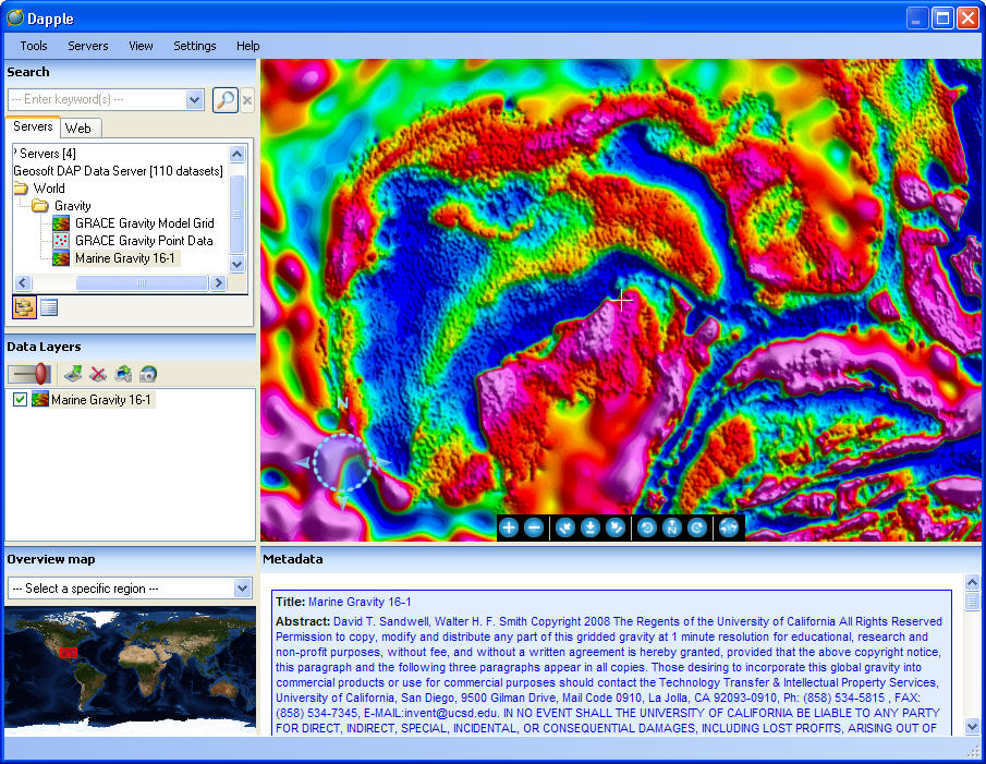 |
"We wanted to provide explorers with a simple way to find data that match their area of interest and the ability to view these data in a visual and meaningful way," said Ian MacLeod, Geosoft chief technologist. "Together, Dapple and DappleSearch provide fast spatial and text search, and show results as thumbnails with full metadata. Explorers are then a click away from displaying data in Dapple."
 |
Geosoft's DappleSearch is a spatial catalogue Web service that creates and maintains a database of active and verified Internet servers that host spatial data services. Just as regular Internet users rely on Google to keep track of the near-limitless resources available online, earth explorers can use DappleSearch to keep track of new spatial data services as they become available.
The Web crawler continually searches new URLs to update the catalogue. To date, the catalogue engine has visited more than one million data layers over the Internet, of which about 200,000 have been accepted into the catalogue index. Periodic re-testing of all indexed services drives the search engine's relevancy.
As Dapple users themselves discover new service sites, the URLs of the service sites are also reported to DappleSearch, which adds each URL to a list of candidates to be considered for the shared catalogue.
What does it all mean for the explorer? Managing exploration data resources, for easy access and maximum reliability, is a key advantage during all phases of a project lifecycle. During early stage exploration, the two or three months previously spent pulling together project data can be reduced to days through the effective leveraging of existing resources and technology enablers. Explorers can make go/no-go decisions more quickly, based on richer information - which means better decisions. These benefits continue once the work is underway.
"Once all the preliminary work is done, explorers are constantly updating their information by collecting and interpreting new data from the field and integrating the results back into their original data sets," says Steve Randall, director of Product Management with Geosoft. "Spatial cataloguing, search and viewer technologies enable easy access and integration of new data as soon as they are available. This means explorers can always be in sync with their data no matter what systems they are using, or when or where they are being accessed. This wasn't the case previously, which often led to delays and inconsistencies in managing the project."
And since time is of the essence, performance and response rate are critical, especially as datasets continue to grow and threaten to degrade system and network performance.
"Explorers need cause and effect to happen instantly, right in front of them," says MacLeod. "We're able to handle absolutely massive catalogues, and from the end user's perspective it's an instantaneous response. We'll continue to spend research and development effort to make sure the technology is as responsive as it can be."
"All of this has huge workflow implications," says Randall. "From finding all the relevant data sources, evaluating them and extracting them back into your interpretation environment, there's so much flexibility that didn't exist even two or three years ago."
Better preparation is also an effective way to maintain competitive advantage. "These technologies can't guarantee you better success rates, but they can guarantee you more time to help you evaluate your decisions," he says. "You can be more effective and productive, which will in turn probably lead to greater success."
Exploration Workflows in GIS
Though GIS has always had a role to play in the search for mineral deposits, adoption of GIS in the exploration industry has grown for several reasons. Not the least of these is the fact that there are more tools available to help explorers effectively work within the GIS environment - conducting advanced geospatial analysis and creating accurate, quality results.
The questions posed by resource exploration and the answers offered by GIS are a natural fit. Exploration teams need to integrate and make sense of reams of geochemical and geological information in order to find ore bodies. GIS supports this complex workflow by managing and analyzing the data and displaying them in a spatial context.
 |
As GIS becomes more mainstream in all aspects of life - from the ever changing political wall maps used by CNN to depict U.S. election results, to Google Map applications that can track a runner's training routes - geoscientists are becoming more comfortable weaving geospatial technology into their workday. The real breakthrough, however, has been adding and improving exploration workflow support for geologists and specialists working with large and multidisciplinary exploration datasets.
"I think one of the most critical aspects in the recent uptake is direct workflow support," says Geoff Wade, ESRI's Natural Resource Industries manager. "But to support the most complex of specialist workflows, GIS really needs to be in the hands of a specialist solution builder. Our global partnership with Geosoft has been essential to fulfilling the specific needs of explorers working within ArcGIS."
In collaboration with ESRI, Geosoft has been building next generation GIS solutions for exploration industries and the geosciences sector.
 |
"We identified several explorer challenges, from basic format incompatibility issues, to a lack of advanced tools for visualizing and interpreting earth datasets (geology, geochemistry and geophysics) inside GIS systems," said Louis Racic, Geosoft's director of Desktop Applications. "And we set out to create a whole solution for explorers that would bridge these gaps."
 |
From an interoperability standpoint, Geosoft has made it a development priority to support all of the leading GIS data formats, and other common data formats, says Racic. "There is nothing more frustrating than spending time fiddling with incompatible data formats. Our goal is to eliminate the need to convert data formats entirely, and free up time for the exploration team to collaborate in an integrated environment."
Geosoft chose to extend its exploration workflows to the ESRI ArcGIS environment to meet customer demand for simpler and more seamless solutions that meet their exploration project needs.
"ESRI technology easily scales to the growing data and spatial challenges that exploration organizations are facing," said Racic. "And we've also seen strong adoption of ArcGIS within global, government geological surveys and the academic geoscience sector."
One result has been strong market demand for Geosoft ArcGIS exploration workflow solutions. "Our Target for ArcGIS extension software was our highest growth product last year, and we were taking orders for the new Geochemistry for ArcGIS before its release to market," said Racic. "We're seeing strong interest in the Geochemistry extension from the government sector as well as the exploration industry."
Geosoft has advanced its exploration strategy in GIS with the recent release of a Geochemistry for ArcGIS extension that extends the explorer's toolkit by providing the ability to analyze geochemical data within the ArcGIS environment, according to Racic. And it provides a powerful exploration workflow solution that's not currently available in the market.
Geochemical investigations require the ability to process and analyze all components of geochemical sampling in context with the geology and geophysics. With the tools available within Geochemistry for ArcGIS, explorers can effectively extract knowledge from their data by examining multivariate relationships, uncovering underlying structures and identifying outliers and anomalies, and then present results by easily creating informative, visually impactful maps.
Using Geochemistry for ArcGIS, explorers can simplify their geochemistry quality control process and maintain data in an ESRI file geodatabase using a data model optimized for geochemical data. They can select and subset data interactively from maps based on lithology and regions to enhance data display; create advanced geochemical maps within the ESRI ArcGIS Desktop environment; and analyze multi-element geochemistry using a variety of tools. These tools include interactive multiple histogram plots, Pearson's correlation reports, scatter plots, probability plots, ternary plots and box plots to identify outliers and define populations.
 |
Wade recommends a gradual adoption of GIS by the exploration department, but one that is incorporated by every member of the interdisciplinary team.
"We find it particularly effective if several members of the project team embrace the technology at the same time, thereby supporting each other in the education process and gaining extra benefit from data sharing, improved workflow support and an improved communication capability," he says.
In addition to workflow support, effective integration of GIS within your exploration organization is also an important consideration. "Technology aside, if you start with a good understanding of your people's data requirements and project workflows, then you are more likely to achieve the results you need," says Racic.
There is no doubt that explorers today, both junior and major, are operating in a rapidly changing exploration environment that is increasingly reliant on data and applications available through the Internet. There's more digital data to makes sense of, greater integration and interpretation challenges and larger drilling projects to manage. For many, the choice is clear: retool to deal with the new complexities of exploration and take advantage of all the rich, digital data and applications coming online, or risk being left behind, and missing out on future opportunities.
From Our Homepage
Saying Farewell to an Amazing Journey
Communicating with Maps
Is There a GIS Career Ladder?
What does it mean to be geospatially smart? Series
Ways Real Estate and Property Developers Utilize Melissa GeoData for Data-Driven Decisions
Unlocking Value From Daily Satellite Imagery and Insights
Maximizing the Value of Your Address Data with Geo Addressing
How Indoor Mapping Enhances the Security of Smart Buildings
Look Ahead: AI, Location Intelligence and Efficiency
Collaboration Takes on Sea Level Rise & Dynamic Technology Environments
Brownies for Brownfields
Has Everything Been Mapped Already?
How Is Data Literacy Changing in an Artificial Intelligence Landscape
Portfolios for GIS Professionals: More Than Just Maps
How to Create a Distance Matrix in QGIS - A Step-by-Step Guide
7 Ideas for Bringing GIS into the K-12 Classroom
The Geography of Movement