ar·chi·tec·ture P n.
- Buildings and other large structures: the low, brick-and-adobe architecture of the Southwest.
- A style and method of design and construction: Byzantine architecture.
- The art and science of designing and erecting buildings.
- Orderly arrangement of parts; structure: the architecture of the federal bureaucracy; the architecture of a novel.
- Computer Science. The overall design or structure of a computer system, including the hardware and the software required to run it, especially the internal structure of the microprocessor.
National systems are not new to us - the North American electric power generation system was built to certain architecture standards - home consumers want their power to be 110 and 220 volts and commercial users may desire 220, 440 or even 660 volts in more than a single phase, but they all oscillate at 60 cycles per second (hertz).Different physical plugs are used for each of the common voltage levels to prevent the unsuspecting from attaching an appliance to the wrong one.Those simple rules are what allow any consumer to plug a hair dryer in and have it work.Europe has a similar system: multiple generation plants, high voltage transmission lines, etc., but they chose to use 220 volts and 50 hertz as the base consumer power level.
It may seem a little strange that the government computer world is just now getting into large-scale architectures, but we must remember that the current power system standards did not blossom overnight either. That reality combined with the computer's ability to adapt and overcome some differences - something that a hair dryer cannot do - help explain the timing.
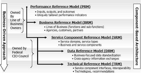 |
The most revolutionary part of this architecture as professed in the FEA documents is that the focus is on the architecture of the business being conducted, which then flows to the requirements of the services, data and technology that are needed to carry it out.The FEA is not intended to yield or describe a purely IT architecture, rather it is designed to assist in the business process re-engineering that may be realized through IT solutions.The computer system itself is subordinated to the needs of the business.FEA starts with what is called the Business Reference Model (BRM), which catalogs the functions and requirements of an organization and its lines of business.
Because the federal government provides services to its citizens, the business of the government, identified in the BRM by Lines of Business, is further decomposed by a Service Reference Model (SRM) that clearly identifies what 'services' are provided.Those services rely on data which are described in the Data Reference Model (DRM), and are realized with software described in the Technical Reference Model (TRM).The frosting on the cake is the Performance Reference Model (PRM), where rules are provided to use in determining agencies' success in using the other models.
In reality, the FEA process is a tool for the government to understand and organize all its business processes, not just those that rely on computers - though there are getting to be fewer and fewer of those. The process provides plenty of opportunities for managers to see, too, how networked computers can be used in an evolutionary or revolutionary way to improve, reorganize or eliminate some business processes.
The revolutionary part of all of this for those of us in the geospatial business is that three areas have been identified as having value for the government as a whole and are not owned by a single Line of Business.All departments have security needs, all of them perform document management activities, and they all require geospatial information and tools!
Note that this does not mean they all use or need to use the classic tool of the geospatial world, the GIS.USGS actually has lines of business (map production for instance) that are mainly geospatial; EPA, FEMA and others have lines of business that are heavily dependent on geospatial analysis and decision-making tools (floodplain mapping, pollution monitoring, etc.); but some agencies may have nothing more geospatial than "ordinary" databases full of street addresses and other spatial references.
The important thing is that it is now officially recognized that all information about government assets and services - and about the citizen beneficiaries of those services - has a location component. Citizens are associated with certain geographies for their government-affiliated services: education, voting, grant eligibility, benefit claims, medical care, recreational opportunities and more. People and many physical assets move from place to place.Governments need to pay attention to changes in land use, land cover, shorelines, population, wealth distribution, transportation, hazards, threats, energy systems, etc.Spatial information is fundamental information, and there is now a high level recognition that this is true.
Architecture is all about pieces that fit together even though they come from different sources.That is to say, many of the benefits of a spatially grounded FEA can be greatly increased through standardization, just as the benefits of an electric power grid were increased through standard voltages and A/C cycles/second.OGC's mission, of course, is to provide a consensus process that supports geospatial technology standardization efforts.
It is important for all major players and stakeholder groups to be represented in such processes.Just at a time when geospatial technology standards and the entire National Spatial Data Infrastructure have become extraordinarily important for public security and safety, disruptive technologies and market trends could destabilize this infrastructure.Government and business need to work together, in open and fair processes, to "architect" an infrastructure that best serves the country.
In order to assure that the emerging FEA infrastructure takes advantage of the benefits of geospatial information, the Federal Geographic Data Committee and the Federal CIO Architecture and Infrastructure Committee are jointly leading an effort to create a Geospatial Profile for the FEA.The FEA Geospatial Community of Practice is on schedule to produce a Geospatial Profile this fall as guidance to agency architects to identify and promote consistent geospatial patterns in their organizational designs.
Time is short, but I encourage all of you to stop by this construction site and let me or one of the others working on the project know what you think.
From Our Homepage
Saying Farewell to an Amazing Journey
Communicating with Maps
Is There a GIS Career Ladder?
What does it mean to be geospatially smart? Series
Ways Real Estate and Property Developers Utilize Melissa GeoData for Data-Driven Decisions
Unlocking Value From Daily Satellite Imagery and Insights
Maximizing the Value of Your Address Data with Geo Addressing
How Indoor Mapping Enhances the Security of Smart Buildings
Look Ahead: AI, Location Intelligence and Efficiency
Collaboration Takes on Sea Level Rise & Dynamic Technology Environments
Brownies for Brownfields
Has Everything Been Mapped Already?
How Is Data Literacy Changing in an Artificial Intelligence Landscape
Portfolios for GIS Professionals: More Than Just Maps
How to Create a Distance Matrix in QGIS - A Step-by-Step Guide
7 Ideas for Bringing GIS into the K-12 Classroom
The Geography of Movement