The Federal Geographic Data Committee (FGDC) held a briefing on June 8th to discuss two topics: the process for adding new National Geospatial Advisory Committee (NGAC) members and the Geospatial Platform Initiative. I participated via a live webcast.
FGDC Executive Director Ivan DeLoatch ran the meeting, which began with an overview of the process for nomination and selection of new NGAC members. The interesting part was not in the briefing but in the questions afterward. I learned that there's a new regulation in effect with the Obama administration that prohibits registered federal lobbyists from participating on federal advisory committees, like NGAC. Questions were raised about diversity on the committee, in particular the limited representation of private providers and those with deep knowledge of geodesy. There was a suggestion to document a preferred or goal "diversity" as a sort of guide for selecting members. Another suggestion addressed the current "tenure" on the committee. Currently, half of the members change every three years. The suggestion was that one-third leave every two years. There were also questions related to NGAC subcommittees, which unlike NGAC committees, can include non-members. A request was made for documentation of who could be on those subcommittees and how they would be selected. We learned that currently there are no non-federal members on any of the subcommittees, but that it is, in fact, possible.
The second topic, the Geospatial Platform Initiative, was lead by Tony Lavoi of the National Oceanic and Atmospheric Administration (NOAA). The impetus for this Initiative was this paragraph in the 2010 budget:
Geospatial Platform - In 2010 and 2011, Federal data managers for geospatial data will move to a portfolio management approach, creating a Geospatial Platform to support GeoOneStop, place-based initiatives, and other potential future programs. This transformation will be facilitated by improving the governance framework to address the requirements of State, local and tribal agencies, Administration policy, and agency mission objectives. Investments will be prioritized based on business needs. The Geospatial Platform will explore opportunities for increased collaboration with Data.gov, with an emphasis on reuse of architectural standards and technology, ultimately increasing access to geospatial data.
A reference to Lavoi's name and affiliation confirmed that a newly found Gulf of Mexico mapping application called geoplatform.gov was, in fact, part of the Geospatial Platform Initiative. In fact, one of the first things Lavoi mentioned was that later on Tuesday, the geoplatform.gov Web address would point to a landing page explaining what it was, with a link to the oil spill mapping app currently on the front page. He noted that individuals should not think that geoplatform.gov was only an oil spill map. (Unfortunately, that confusion had already proliferated on Twitter and on at least one blog, ours.) The reason for the confusion? Apparently it took far less time for NOAA to acquire the domain than expected. Thus the decision was made to have it point to the already in development oil spill app.
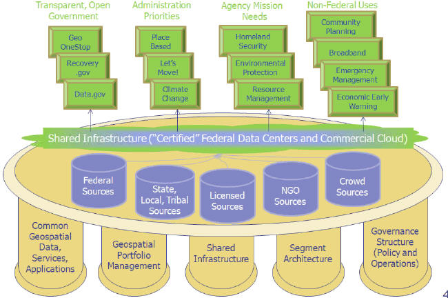
Lavoi discussed the architecture of the platform - which will include five "pillars" including:
- common spatial data, services and applications
- geospatial portfolio management
- share infrastructure
- segment architecture
- governance structure
- (Lavoi noted that there probably should be a sixth, communication)
These tap into a set of data sources including:
- federal
- state, local and trial
- licensed
- NGO
- crowd sources
Together these parts create a platform that supports transparent, open government needs (such as Geospatial One-Stop), administration priorities (like the First Lady's Let's Move), agency mission needs (like homeland security) and non-federal uses (like broadband initiatives).
 |
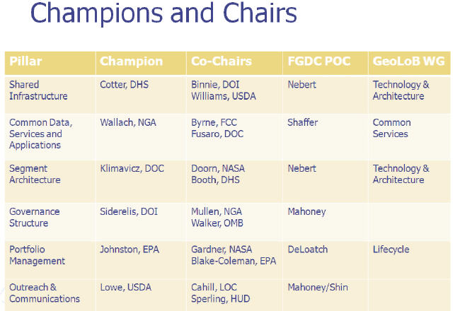
Lavoi introduced the "Champions and Chairs" assigned to take the lead on the various parts of the effort. The platform roadmap, a white paper on the plan for the Geospatial Platform, is due to be delivered to the Office of Management and Budget (OMB) by the Department of Interior (DOI) by July 1. NGAC members will provide feedback on the roadmap document during May and June. Stakeholders' and public comment on the roadmap will begin when the final document (version 3) is handed over to OMB.
 |
The questions and answers (mostly from DeLoatch and Lavoi) included (paraphrased):
Q: How is this platform different from Geospatial One Stop (GOS)?
A: GOS is a catalog; the geospatial platform is more of an enterprise approach with data access and shared apps and services.
Q: How will private data sources be included?
A: We are working on that but want to be sure all possible data sources are on the table. Some may not be publicly available.
Q: How will you get input about private data sources?
A: During the public gathering of feedback.
Q: Where's the data? We don't yet have the NSDI, and thus do not have the framework data layers we need for this effort!
A: No, but we can expose what we do have and point out what's missing and any limitations.
Q: Define "Authoritative Data."
A: That's perhaps not the right term; what we really need is to include data of "known quality."
Q: Will the geospatial platform replace existing apps or simply be "another one"?
A: It will integrate platforms including, for example, The National Map and the Homeland Security Infrastructure Program (HSIP). [My understanding is that it will become the back end of all of the geo apps in time. - ABS]
Q: Can you coordinate better with stakeholder organizations, such as NSGIC and its Inventory tool?
A: Yes, we plan to do that.
Q: It's great there is a focus on communications. There is already confusion.
A: Yes, I'm aware of that and have printouts from blogs.
My sense from the briefing was that things were moving at breakneck speed to meet the July 1 goal. DOI GIO Karen Siderelis summed that up very nicely: "This Administration has a bias toward action." However, as we go to press, geoplatform.gov still points to an oil spill application.