In May, Korem launched
a website aimed at MapInfo Professional users that allows them to
share their workspaces and associated files. Adena Schutzberg asked
Korem's vice president and CTO, Jean-Sébastien
Turcotte, about the product.
Adena Schutzberg (AS): What is mapworkspace? At whom is it aimed?
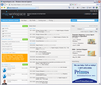
Jean-Sébastien Turcotte (JT): Mapworkspace is a map networking service intended for MapInfo Professional users to publish and share their maps and associated documents with other professionals, and to communicate and exchange information with their peers. Mapworkspace is data independent, enabling users with complete control over all the data in the map. Public access allows non-GIS professionals to consult published information and interact with the authors.
Mapworkspace can be thought of as a combination of Facebook and YouTube but dedicated to sharing mapping information. Through its community-focused functionalities, such as contact management, favorites, tags and messaging, users easily interact with each other, explore the available mapping information and keep track of newly published maps with topics that are of interest to them.
Basically, KOREM has developed a tool intended for MapInfo Professional users to share their work with peers or the general public. This tool offers ease-of-use and focuses on a networking community.
AS: Can you describe the business model?
JT: Because it is based on a community concept, the standard subscription to mapworkspace is available for free. Anyone can register on the website and automatically have access to up to 50 MB of disk space to start sharing their maps within the community.
Since there is no charge to register for a standard subscription, our revenue model relies on other sources:
AS: What are the current features and licensing options? And what new features are planned?
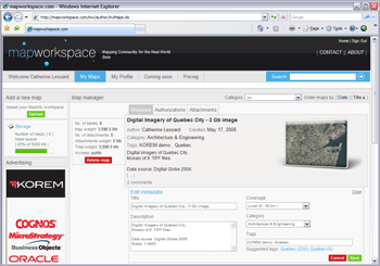
JT: Mapworkspace publication and map management is very straightforward and user-friendly. Users select their workspace on their desktop and the system transfers all of the required files for the map onto the server. Then, they can add information related to the published map, manage access and attach relevant documents (such as XLS, word and PDF reports) to complement the map. Users are kept informed about the disk space they are using and they can upgrade their subscription whenever necessary.
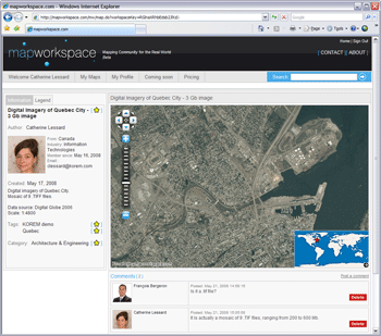
The map browser currently provides the following browsing tools: zoom in, zoom out and pan, and an overview map. Tab options allow for consulting information related to the author and the map legend.
Licensing options
Because the sense of community is one of the most important features of the service, we are providing a free subscription to users who will share their maps and information within the community. The free subscription package provides users with all the basic functionalities of the product. At this level, they are granted with 50Mb of space to publish their information.
Whenever additional disc space becomes necessary, they can easily move up to a paid subscription package. These packages are defined by hard drive space and number of maps viewed outside of the community (using the embed code).
Other types of packages for groups of users sharing maps privately, as well as online subscriptions, will soon be available.
We are aware that some organizations may wish to use the application in a more a private way, sharing their corporate data internally. This is why we have decided to offer mapworkspace as an enterprise solution as well, so that it can be installed on an internal server for private use. The application can be adapted to the business needs and features can be added in order for the tool to be used in a specific context of application.
Upcoming features
We have built mapworkspace under the premise of a continuously evolving environment. We plan on adding new features and functionalities to the website on a regular basis. These updates will generally be minor in nature, but from time to time, we will push a major release that will significantly enhance the user experience.
Every registered user will be informed of upcoming enhancements and will automatically benefit from them as soon as they become available. We also encourage our users to request new functionalities and we count on them to provide feedback on existing ones. We will carefully consider every proposal and select the most relevant ones to integrate in subsequent releases.
As of now, here is a non-exhaustive list of the significant enhancements already planned.
Some of these enhancements will be available through specific paid registration packages:
JT: MapWorkspace is truly unique with its map networking community approach and its ease-of-use for publishing and sharing maps. Although solutions currently exist letting users add simple geographic information to freely available online services, our approach differs because mapworkspace offers MapInfo Professional users complete control over the content and allows them to share it with their peers or anyone interested in that content.
GeoCommons also has a sense of community but it's more geared toward the sharing of base data (Tables) in formats such as KML and SHP with its Finder application. The Maker application, unavailable as of yet, seems a bit similar but we have little information on how the maps will be created. We are promoting the use of existing GIS systems (such as MapInfo Pro) for the GIS professionals to create their maps and then share them with mapworkspace. Also, we believe the community-focused functionalities are what make mapworkspace unique.
ERDAS TITAN is a solution that helps organizations structure and share data internally, but it still has some capabilities to share with users outside the organization. Instant messaging requires any client to view the map and again is a lot more geared toward a community-focused approach and sharing on the Web the end work of GIS professionals, not the source data.
AS: In mapworkspace maps can be tagged when uploaded. Are there any other provisions for storing metadata?
JT: User-defined tags are only one way of associating your maps with specific themes, subjects or key words; they can also be classified under specific predefined categories, creating in both cases a sort of searchable index. Moreover, the author of a map is provided with an interface to create a description of his maps and attach documents as complementary information. I must add that all of this metadata is searchable. As mentioned above, new features and functionalities will be added to mapworkspace on a regular basis.
AS: Can you share information about the underlying technology?
JT: Mapworkspace is based on the Push'n'See technology from KOREM. It takes advantage of some of the Push'n'See capabilities as it gives users total flexibility on the content of their maps. The application is 100% Java, requires no plug-in for navigation and offers ease of deployment of maps in any website .
Adena Schutzberg (AS): What is mapworkspace? At whom is it aimed?
Jean-Sébastien Turcotte (JT): Mapworkspace is a map networking service intended for MapInfo Professional users to publish and share their maps and associated documents with other professionals, and to communicate and exchange information with their peers. Mapworkspace is data independent, enabling users with complete control over all the data in the map. Public access allows non-GIS professionals to consult published information and interact with the authors.
Mapworkspace can be thought of as a combination of Facebook and YouTube but dedicated to sharing mapping information. Through its community-focused functionalities, such as contact management, favorites, tags and messaging, users easily interact with each other, explore the available mapping information and keep track of newly published maps with topics that are of interest to them.
Basically, KOREM has developed a tool intended for MapInfo Professional users to share their work with peers or the general public. This tool offers ease-of-use and focuses on a networking community.
 |
AS: Can you describe the business model?
JT: Because it is based on a community concept, the standard subscription to mapworkspace is available for free. Anyone can register on the website and automatically have access to up to 50 MB of disk space to start sharing their maps within the community.
Since there is no charge to register for a standard subscription, our revenue model relies on other sources:
- Paid subscription service offers various packages for additional disc space.
- Mapworkspace can be purchased as an “enterprise solution” for in-house deployment. The application can therefore be adapted to the organization's specific business context.
- Advertising is also available in specific locations throughout the website .
AS: What are the current features and licensing options? And what new features are planned?
JT: Mapworkspace publication and map management is very straightforward and user-friendly. Users select their workspace on their desktop and the system transfers all of the required files for the map onto the server. Then, they can add information related to the published map, manage access and attach relevant documents (such as XLS, word and PDF reports) to complement the map. Users are kept informed about the disk space they are using and they can upgrade their subscription whenever necessary.
The map browser currently provides the following browsing tools: zoom in, zoom out and pan, and an overview map. Tab options allow for consulting information related to the author and the map legend.
 |
Licensing options
Because the sense of community is one of the most important features of the service, we are providing a free subscription to users who will share their maps and information within the community. The free subscription package provides users with all the basic functionalities of the product. At this level, they are granted with 50Mb of space to publish their information.
Whenever additional disc space becomes necessary, they can easily move up to a paid subscription package. These packages are defined by hard drive space and number of maps viewed outside of the community (using the embed code).
Other types of packages for groups of users sharing maps privately, as well as online subscriptions, will soon be available.
We are aware that some organizations may wish to use the application in a more a private way, sharing their corporate data internally. This is why we have decided to offer mapworkspace as an enterprise solution as well, so that it can be installed on an internal server for private use. The application can be adapted to the business needs and features can be added in order for the tool to be used in a specific context of application.
Upcoming features
We have built mapworkspace under the premise of a continuously evolving environment. We plan on adding new features and functionalities to the website on a regular basis. These updates will generally be minor in nature, but from time to time, we will push a major release that will significantly enhance the user experience.
Every registered user will be informed of upcoming enhancements and will automatically benefit from them as soon as they become available. We also encourage our users to request new functionalities and we count on them to provide feedback on existing ones. We will carefully consider every proposal and select the most relevant ones to integrate in subsequent releases.
As of now, here is a non-exhaustive list of the significant enhancements already planned.
Some of these enhancements will be available through specific paid registration packages:
- Capability to embed a map in an external website (available in August)
- New map navigation tools such as information, search, layer control, email and print
- User forum and messaging
- Group and user management
- Online payment
- Map recommendation based on the currently viewed map
- Integration of external data feeds to an existing map (GeoRSS, KML, WMS, WFS)
JT: MapWorkspace is truly unique with its map networking community approach and its ease-of-use for publishing and sharing maps. Although solutions currently exist letting users add simple geographic information to freely available online services, our approach differs because mapworkspace offers MapInfo Professional users complete control over the content and allows them to share it with their peers or anyone interested in that content.
GeoCommons also has a sense of community but it's more geared toward the sharing of base data (Tables) in formats such as KML and SHP with its Finder application. The Maker application, unavailable as of yet, seems a bit similar but we have little information on how the maps will be created. We are promoting the use of existing GIS systems (such as MapInfo Pro) for the GIS professionals to create their maps and then share them with mapworkspace. Also, we believe the community-focused functionalities are what make mapworkspace unique.
ERDAS TITAN is a solution that helps organizations structure and share data internally, but it still has some capabilities to share with users outside the organization. Instant messaging requires any client to view the map and again is a lot more geared toward a community-focused approach and sharing on the Web the end work of GIS professionals, not the source data.
AS: In mapworkspace maps can be tagged when uploaded. Are there any other provisions for storing metadata?
JT: User-defined tags are only one way of associating your maps with specific themes, subjects or key words; they can also be classified under specific predefined categories, creating in both cases a sort of searchable index. Moreover, the author of a map is provided with an interface to create a description of his maps and attach documents as complementary information. I must add that all of this metadata is searchable. As mentioned above, new features and functionalities will be added to mapworkspace on a regular basis.
 |
AS: Can you share information about the underlying technology?
JT: Mapworkspace is based on the Push'n'See technology from KOREM. It takes advantage of some of the Push'n'See capabilities as it gives users total flexibility on the content of their maps. The application is 100% Java, requires no plug-in for navigation and offers ease of deployment of maps in any website .
From Our Homepage
Saying Farewell to an Amazing Journey
Communicating with Maps
Is There a GIS Career Ladder?
What does it mean to be geospatially smart? Series
Ways Real Estate and Property Developers Utilize Melissa GeoData for Data-Driven Decisions
Unlocking Value From Daily Satellite Imagery and Insights
Maximizing the Value of Your Address Data with Geo Addressing
How Indoor Mapping Enhances the Security of Smart Buildings
Look Ahead: AI, Location Intelligence and Efficiency
Collaboration Takes on Sea Level Rise & Dynamic Technology Environments
Brownies for Brownfields
Has Everything Been Mapped Already?
How Is Data Literacy Changing in an Artificial Intelligence Landscape
Portfolios for GIS Professionals: More Than Just Maps
How to Create a Distance Matrix in QGIS - A Step-by-Step Guide
7 Ideas for Bringing GIS into the K-12 Classroom
The Geography of Movement