Our
firm specializes in engineering and architecture, inventory and
asset management, as well as environmental science, and we collect a
high volume of geospatial information for most of our projects.
Typical engagements range from short-term, six month contracts to 20
years or longer for government agencies, corporations, universities and
other organizations nationwide. While the nature of our work varies by
situation, efficient decision making based on field data is at the core
of our work. We recently integrated the use of a new digital pen and
paper software platform, Capturx for ArcGIS Desktop, into our field
operations. As a result, we have experienced greater employee
satisfaction at all levels, achieved significant time and cost savings,
and gained the ability to make quick, well-informed decisions.
Project Scenarios
Traditional pen and paper has been the preferred mode of data collection among our field force since day one - it is familiar, comfortable and natural for them to use and allows them to "huddle and scrawl" around a map. About five years ago, we deployed a handful of GPS systems to help our engineers gather inventory data in the field. In addition, to streamline the way we work and expedite data transfer, we tested out the use of rugged PCs.
To paint a picture of the diverse nature of our work, below are two very distinct examples of projects in which efficient field data management is essential - first for inventory and asset management, and second for wetland delineation.
Our inventory and asset management project teams are comprised of field employees, engineers, environmental scientists, planners and construction workers who find and record a very descriptive inventory of electrical, water, sewer and gas systems. This information is used in an inventory asset management system or to populate utility models for doing detailed analysis of the systems. Our engineers and scientists have been out in the field collecting data because they are knowledgeable about the intricacies of the system and can identify the model, type, size, additional attributes and the condition of a power pole, for example, and, of course, tie that into where it is located on a map. Our field staff serves as support in this process.
Our wetland delineation projects are a direct response to meet nationwide permit requirements under section 404 of the Clean Water Act. Environmental scientists need to mark up maps during site visits to show the current condition of the areas that are suspected to be wetlands. Part of the permit requires us to annually take inventory and record size measurements of the trees to ensure they are growing and can survive on their own without harm from animals or disease. We capture the number of trees by species native to the specific area when we build a reservoir or put in a water pipeline. We have to be careful not to destroy too much habitat while we're at it. We look at the soil and evaluate which types thrive relative to the local environment. For all trees destroyed, we have to create a mitigation area where the same species of trees are replanted according to ratios specified in the permits. This is monitored by government bodies, and each year we need to go back to take inventory, as part of the long-term management of the trees.
Challenges
The biggest challenge we faced was how to capture and share mission-critical field data that drive key decisions in a timely and efficient manner that, most importantly, our field teams would adopt. Some of the personnel and logistical issues we were up against became even clearer as we attempted to automate some of our processes.
Dependence of field engineers and staff on traditional pen and paper for data collection led to critical time lags between field data collection and entering information back into a central database for management to access and review. Inherent in the transcription process was the risk of errors in the data entry process due to difficulty reading multiple engineers' notes and papers getting wet or crumpled while out in the field, making them hard to decipher.
We explored using tablet PCs, however these were not convenient for field staff to carry and they were simply not comfortable using them, not to mention the fact that the laptops were often dropped. The cost of each machine, plus repairs, represented a big financial investment for us that did not pay off.
It became obvious very early on that the GPS devices didn't work well for staff because most of them are not very technical and they found the devices hard to learn. The drop-down menus did not provide adequate options to collect the level of detail required. As a result, the devices took more time to use, required the engineers to get out of their car to wait for a signal, and could not capture all the relevant data that could be recorded by hand. Varying field conditions, from underground manholes to being knee deep in the wetlands amidst dense populations of large trees, also made it difficult to maneuver with the unit in hand. In remote areas a signal was not available, so they didn't work at all under those circumstances.
Deploying these technologies was a challenge for us due to the resistance to changing familiar business practices and learning a new system of working. Since pen and paper prevailed as a common language across the team, we began to research other options.
Solution
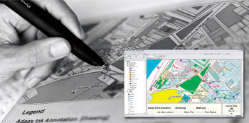
After in-depth research and much discussion about field data management solutions, we realized that the digital pen and paper software platform from Adapx was the solution for us. Their product, Capturx for ArcGIS Desktop, allows us to stick to business as usual by digitizing data captured with their pen, with transcription as quick and easy as docking the pen into a computer. In the near future, we also plan to use Capturx for AutoCAD so we can instantly mark up, annotate, and redline any CAD drawing, then upload the field data into any AutoCAD application as soon as we return to the office.
We selected Capturx because we were looking to simplify our data collection and management process. The technology speaks for itself; it is intuitive to use and integrates into our existing business applications - ArcGIS, OneNote and AutoCAD.
How It Works
Field staff and engineers take notes, make comments, and draw sketches or diagrams on regular paper maps as they normally would. The difference is that the Capturx digital pen records each key stroke as digital ink, and maps are printed on regular paper that is watermarked by a special Anoto pattern to record the geospatial component of the data. Back in the office, a staff person then docks the pen into the USB port on a PC, and the notes become immediately available in ArcGIS without any additional work.
Results
By automating the favored data collection method among our field staff, Adapx digital pen and paper solution was immediately well received and incredibly easy to use -- with no formal training. Thus far, our experience with deploying and using Capturx for ArcGIS Desktop has been very smooth with major upsides and no real downside. The intangible benefits relate primarily to how well both field and office-based staff have embraced the digital pen and paper software solution from Adapx. Using Capturx, our field teams no longer have to re-enter field data. Since data is shared more frequently and at a faster pace, we benefit from a more effective use of time and resources as well as a significant return on investment.
Project Scenarios
Traditional pen and paper has been the preferred mode of data collection among our field force since day one - it is familiar, comfortable and natural for them to use and allows them to "huddle and scrawl" around a map. About five years ago, we deployed a handful of GPS systems to help our engineers gather inventory data in the field. In addition, to streamline the way we work and expedite data transfer, we tested out the use of rugged PCs.
To paint a picture of the diverse nature of our work, below are two very distinct examples of projects in which efficient field data management is essential - first for inventory and asset management, and second for wetland delineation.
 |
Our inventory and asset management project teams are comprised of field employees, engineers, environmental scientists, planners and construction workers who find and record a very descriptive inventory of electrical, water, sewer and gas systems. This information is used in an inventory asset management system or to populate utility models for doing detailed analysis of the systems. Our engineers and scientists have been out in the field collecting data because they are knowledgeable about the intricacies of the system and can identify the model, type, size, additional attributes and the condition of a power pole, for example, and, of course, tie that into where it is located on a map. Our field staff serves as support in this process.
Our wetland delineation projects are a direct response to meet nationwide permit requirements under section 404 of the Clean Water Act. Environmental scientists need to mark up maps during site visits to show the current condition of the areas that are suspected to be wetlands. Part of the permit requires us to annually take inventory and record size measurements of the trees to ensure they are growing and can survive on their own without harm from animals or disease. We capture the number of trees by species native to the specific area when we build a reservoir or put in a water pipeline. We have to be careful not to destroy too much habitat while we're at it. We look at the soil and evaluate which types thrive relative to the local environment. For all trees destroyed, we have to create a mitigation area where the same species of trees are replanted according to ratios specified in the permits. This is monitored by government bodies, and each year we need to go back to take inventory, as part of the long-term management of the trees.
Challenges
The biggest challenge we faced was how to capture and share mission-critical field data that drive key decisions in a timely and efficient manner that, most importantly, our field teams would adopt. Some of the personnel and logistical issues we were up against became even clearer as we attempted to automate some of our processes.
Dependence of field engineers and staff on traditional pen and paper for data collection led to critical time lags between field data collection and entering information back into a central database for management to access and review. Inherent in the transcription process was the risk of errors in the data entry process due to difficulty reading multiple engineers' notes and papers getting wet or crumpled while out in the field, making them hard to decipher.
We explored using tablet PCs, however these were not convenient for field staff to carry and they were simply not comfortable using them, not to mention the fact that the laptops were often dropped. The cost of each machine, plus repairs, represented a big financial investment for us that did not pay off.
It became obvious very early on that the GPS devices didn't work well for staff because most of them are not very technical and they found the devices hard to learn. The drop-down menus did not provide adequate options to collect the level of detail required. As a result, the devices took more time to use, required the engineers to get out of their car to wait for a signal, and could not capture all the relevant data that could be recorded by hand. Varying field conditions, from underground manholes to being knee deep in the wetlands amidst dense populations of large trees, also made it difficult to maneuver with the unit in hand. In remote areas a signal was not available, so they didn't work at all under those circumstances.
Deploying these technologies was a challenge for us due to the resistance to changing familiar business practices and learning a new system of working. Since pen and paper prevailed as a common language across the team, we began to research other options.
Solution
After in-depth research and much discussion about field data management solutions, we realized that the digital pen and paper software platform from Adapx was the solution for us. Their product, Capturx for ArcGIS Desktop, allows us to stick to business as usual by digitizing data captured with their pen, with transcription as quick and easy as docking the pen into a computer. In the near future, we also plan to use Capturx for AutoCAD so we can instantly mark up, annotate, and redline any CAD drawing, then upload the field data into any AutoCAD application as soon as we return to the office.
We selected Capturx because we were looking to simplify our data collection and management process. The technology speaks for itself; it is intuitive to use and integrates into our existing business applications - ArcGIS, OneNote and AutoCAD.
How It Works
Field staff and engineers take notes, make comments, and draw sketches or diagrams on regular paper maps as they normally would. The difference is that the Capturx digital pen records each key stroke as digital ink, and maps are printed on regular paper that is watermarked by a special Anoto pattern to record the geospatial component of the data. Back in the office, a staff person then docks the pen into the USB port on a PC, and the notes become immediately available in ArcGIS without any additional work.
 |
 |
By automating the favored data collection method among our field staff, Adapx digital pen and paper solution was immediately well received and incredibly easy to use -- with no formal training. Thus far, our experience with deploying and using Capturx for ArcGIS Desktop has been very smooth with major upsides and no real downside. The intangible benefits relate primarily to how well both field and office-based staff have embraced the digital pen and paper software solution from Adapx. Using Capturx, our field teams no longer have to re-enter field data. Since data is shared more frequently and at a faster pace, we benefit from a more effective use of time and resources as well as a significant return on investment.
From Our Homepage
Saying Farewell to an Amazing Journey
Communicating with Maps
Is There a GIS Career Ladder?
What does it mean to be geospatially smart? Series
Ways Real Estate and Property Developers Utilize Melissa GeoData for Data-Driven Decisions
Unlocking Value From Daily Satellite Imagery and Insights
Maximizing the Value of Your Address Data with Geo Addressing
How Indoor Mapping Enhances the Security of Smart Buildings
Look Ahead: AI, Location Intelligence and Efficiency
Collaboration Takes on Sea Level Rise & Dynamic Technology Environments
Brownies for Brownfields
Has Everything Been Mapped Already?
How Is Data Literacy Changing in an Artificial Intelligence Landscape
Portfolios for GIS Professionals: More Than Just Maps
How to Create a Distance Matrix in QGIS - A Step-by-Step Guide
7 Ideas for Bringing GIS into the K-12 Classroom
The Geography of Movement