
Disasters, both natural and man-made that victimize large numbers of people and cause significant social and economic losses, urgently demand special attention.The disaster management sector needs drastic developments and improvements to decrease damage and save lives of civilians.
Geo-information technology
Some of the lessons learned in the last several years give clear indications that availability, management and presentation of geo-information play a critical role in disaster management. Geo-information technologies offer a variety of opportunities to aid management and recovery in the aftermath of industrial accidents, road collisions, complex emergencies, earthquakes, fires, floods and similar catastrophes.The most resent examples are from the tsunami on 26 December 2004 in Asia.The role of geo-information (satellite images and GIS) in the aftermath of the tsunami remains to be discussed, analysed and compared in detail.
Disaster management poses significant challenges for data collection, data management, discovery, translation, integration, visualisation and communication.Effective disaster management requires the thorough use and understanding of the semantics of the heterogeneous (geo-) information sources with their many differences: scale/resolution, dimension (2D or 3D), classification and attributes schemes, temporal aspects (up-to-date-ness, history, predictions of the future), spatial reference system used, etc.
It is often stated that the major problem in disaster management is not lack of technology or the existence of relevant information, but lack of 'information' about the information.This is especially true for geo-information.Typically, disaster management depends on large volumes of accurate, relevant, on-time geo-information that various organizations systematically create and maintain.This information may be described in catalogues and made available through geo-information infrastructures, such as the Infrastructure for Spatial Information in Europe (INSPIRE), based on OGC, ISO, and CEN standards.While the semantics of geo-information might be clear to the producer, this may not be the case for users less familiar with the data.Therefore explicit, and preferably formal semantics are required, but currently seldom available.This complicates the effective (fast and good quality) communication of data to the user in real-time machine processing in support of disaster management.
Context awareness
New context-aware technologies need to be operable in multi-risk, multi-user and multi-technology environments.These context-aware technologies can provide access to needed information, facilitate the interoperability of emergency services, and provide high quality care to the public.A range of different geo-information technologies is required for this, ranging from data collection (in advance but also real-time updates during 'action') via processing (storage, analysis, knowledge-based translation and integration, etc.) to presentation and user interaction.Real-time positioning and navigation technologies, both indoor and outdoor, are used to obtain the much needed aspect of locational context awareness.
Some other important context awareness aspects include the tasks and skill of the user (working at either a detailed or an aggregated overview level) and the interaction capabilities of the available devices both for output (2D/3D graphics on screens, sound or speech, and other possible contact/touch-based signals) and input (text, speech, pointing, etc.).Knowledge bases must be available and maintained with the pre-analyses geo-information (technology) needs of the different tasks for different contexts.In case of emergencies or disasters this knowledge can be applied (semi-) automatically in order to be able to provide effective support.
Symposium motivation
Anticipating the obvious and growing importance of geo-information for disaster and risk management, the authors decided to organize The First International Symposium on Geo-information for Disaster Management.The meeting will take place in Delft, The Netherlands, March 21-23.It begins a wide discussion on collection, management, analysis, sharing and visualisation of geo-information.One thing was sure when we started to organize this symposium last year: there will always be more (natural or man-made) disasters all over the world that need advanced geo-information technology to optimize the disaster management (both before and after situations).Unfortunately, in the meantime this has been proven to be very true with disasters with effects ranging from local to near global scales.The fundamental goal of the Symposium is therefore to improve these situations and to tackle disaster management problems in their entirety, considering: technology (both software and hardware applicable for disaster management), user requirements for geo-information (both management and mobile users), and information providers (data and standards).
During the Symposium the following aspects will be addressed:
- The state-of-the-art in disaster management;
- A review of tools, software, existing geo-information sources, organizational structures and methods for work in crisis situations;
- An outline of the drawbacks in current use, discovery, integration and exchange of geo-information; and
- Some suggestions for future research directions.
Symposium format
The symposium on will include 22 plenary oral presentation, 49 oral presentation to be presented in 12 parallel sessions and about 30 poster presentations.These contributions are organized in sessions according a specific focus on one of the following topic:
- User Needs, Requirements and Technology Developments
- Data Collection and Data Management
- Data Integration and Knowledge Discovery
- End-user Environments
- Positioning and Location-based Communication
- Information systems for specific disaster management applications
- Michael Goodchild (University of California, Santa Barbara, USA): Geo-information science for disaster management
- Richard Guillande (GeoSciences Consultants s.a.r.l, Bagneux, France): Fast delivery of geo-information for disaster recovery after the tsunami in South East Asia
- Johan Remkes (Netherlands Minister of the Interior and Kingdom Relations, invited): Geo-information and disaster management from the perspective of a responsible national government
- D.Muhally Hakim (Bandung Institute of Technology, Indonesia): Local geo-information support for disaster management for Banda Atjeh.
Recognizing the importance of disaster management issues, several universities, international organizations and vendors have taken the initiative to make this symposium an annual event, which will be organized on different continents.Three follow-up symposiums are already planned: India (2006), Canada (2007) and China (2008).The ISPRS will support these symposia.
Any symposium takes considerable effort, and this one - being the first - especially.The local organizers would like to express their appreciation and gratitude to all authors whom submitted an extended abstract and the members of the Scientific Program Committee for completing the review process on which the selection of the final contributions was based.Most of these contributions are now included in a 1,500 page book published by Springer Verlag, and make available to all symposium participants.
Such an event cannot be organized without the support of the international scientific community and the ICT industry.Special thanks goes to the international organizations: ISPRS, EuroSDR, AGILE, and UNOOSA, for recognizing the importance of this symposium and the sponsors: GIN, RWS-AGI, Intergraph, Bentley, ESRI, and TU Delft/GDMC. This symposium is the result of the research program titled, 'Sustainable Urban Areas' (SUA), carried out at Delft University of Technology.
Following are several samples from the extended abstracts submitted.
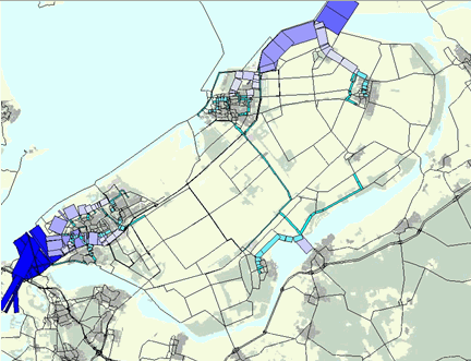 |
A Decision
Support System for Preventive Evacuation of People Kasper van Zuilekom, Martin van Maarseveen and Marcel van der Doef, pp. 231-253 (Image at left shows evacuation routes.Click image for larger view.) |
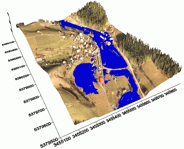 |
Accurate On-Time
Geo-Information for Disaster Management and Disaster Prevention by
Precise Airborne Lidar Scanning Steffen Firchau and Alexander Wiechert, pp.109-119 (Image at left shows a water flood simulation.Click image for larger view.) |
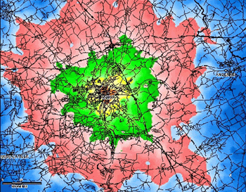 |
Geo-Information
at the Belgian Federal Crisis Centre Monique Bernaerts and Philippe Hellemans, pp.416-424 (Image at left demonstrates risk zones.) |
 |
A
Distributed Spatial Data Library for Emergency Management Tony Hunter, pp.373-350 (Image at left shows a conceptual model of the modeling, operational and data domains and their interrelationships.Click image for larger view.) |
From Our Homepage
Saying Farewell to an Amazing Journey
Communicating with Maps
Is There a GIS Career Ladder?
What does it mean to be geospatially smart? Series
Ways Real Estate and Property Developers Utilize Melissa GeoData for Data-Driven Decisions
Unlocking Value From Daily Satellite Imagery and Insights
Maximizing the Value of Your Address Data with Geo Addressing
How Indoor Mapping Enhances the Security of Smart Buildings
Look Ahead: AI, Location Intelligence and Efficiency
Collaboration Takes on Sea Level Rise & Dynamic Technology Environments
Brownies for Brownfields
Has Everything Been Mapped Already?
How Is Data Literacy Changing in an Artificial Intelligence Landscape
Portfolios for GIS Professionals: More Than Just Maps
How to Create a Distance Matrix in QGIS - A Step-by-Step Guide
7 Ideas for Bringing GIS into the K-12 Classroom
The Geography of Movement