Geo-Temporal
Visualization of RFID
Providing Global Visibility of the DoD Supply Chain
(Part 1 of 2)
David Shuping (FC Business Systems) and William Wright (Oculus Info, Inc.)
Providing Global Visibility of the DoD Supply Chain
(Part 1 of 2)
David Shuping (FC Business Systems) and William Wright (Oculus Info, Inc.)
Ed Note: This article takes the traditional applications of RFID and applies the concepts of time and space, with 2D and 3D visualization to make the supply chain almost appear as a living, breathing entity.Showing the dynamics of supply beyond the mere movement of goods and unfolding the process in real and near real time, the article gives several added dimensions to the understanding of Location Intelligence.
Abstract
The use of Radio Frequency Identification (RFID) technology is expanding rapidly in both commercial and Department of Defense (DoD) supply chains.Many resources within the RFID research and development community have been focused on hardware and firmware components, including active and passive RFID tags, tag readers, and embedded software, yet fewer resources have been focused on exploiting the data collected by tag readers and stored in electronic databases.GeoTime™ visualization exploits the collection and storage of RFID data, and provides global in-transit visibility of the DoD supply chain down to the last tactical mile.
Background
DoD recognizes the value of expanding their global RFID infrastructure and sees a RFID-capable supply chain as a critical element of defense transformation [Wynne, 2004].Beginning in January 2005, DoD has mandated the use of RFID for specific product types (packaged operational rations, clothing, individual equipment, tools, personal demand items, and weapons systems repair parts) shipped to specific defense depots (Susquehanna, PA and San Joaquin, CA).In January 2006, DoD mandates will expand to include most product types and most military service and defense depots [DoD, 2004].
Currently, the DoD's Product Manager for Joint Automatic Identification Technology (PM J-AIT) is managing over 1,500 RFID read/write stations in 25 states and 20 countries around the world.These read/write stations will provide supply chain data to five In-Transit Visibility (ITV) servers.The data contained on the ITV servers provides the basis for monitoring the entire DoD supply chain on a near real-time basis.The challenge is to create a visual display of critical data elements that provides military commanders with information such as "Where are my supplies right now?" and "When will those supplies get to my troops?"
1 Introduction
1.1 Information Visualization Benefits
Animated two and three-dimensional computer graphics are extremely expressive.With the correct approach to the visual design of the display and the objects, large amounts of information, such as global RFID data collected by thousands of electronic tag readers, can be quickly and easily comprehended by a human observer.When information is presented visually, efficient innate human capabilities can be used to perceive and process data.Orders of magnitude more information can be seen and understood in a few minutes.Information visualization techniques amplify understanding by increasing human mental resources, reducing search times, improving recognition of patterns, increasing inference making, and increasing monitoring scope [Card, 1999], [Ware, 2000].These benefits translate into system and task-related performance factors which speed the completion of analysis, decision-making, and communication tasks.The time, effort and number of work products required to do these types of tasks are reduced [Wright and Kapler, 2002].
1.2 Visualization of Events in Time and Geography
Many visualization techniques for analyzing complex event interactions only display information along a single dimension, typically one of time, geography or network connectivity.Each of these types of visualizations is common and well understood.For example, time-focused scheduling charts such as Lifelines [Plaisant et al, 1996] or Microsoft (MS) Project display attributes of events over the single dimension of time.A Geographic Information System (GIS) product, such as MS MapPoint, or ESRI ArcView, shows events in the single dimension of locations on a map.There are also link analysis tools, such as Netmap (www.netmapanalytics.com), Visual Analytics (www.visualanalytics.com), and Analyst Notebook (www.i2inc.com) that display events as a network diagram, or graph of objects and connections between objects.These tend to be one-dimensional displays that show either organizational structures, timelines, communication networks, or locations.In each case, only a thin slice of a multidimensional picture is portrayed.
Some of these systems are capable of using animation to display time.Time is played back, or scrolled, and the related spatial displays change to reflect the state of information at a moment in time, however this technique relies on limited human short term memory to retain temporal changes and patterns.One technique, called "Tracks", is often used in Air Force and Navy command and control systems to show on a map surface the trails of moving entities.Another visualization technique called "small multiples" [Tufte, 1990] uses repeated frames of a condition or chart, each capturing an incremental moment in time, much like looking at sequence of frames from a film laid side by side.Each image must be interpreted separately, and side-by-side comparisons made, to detect differences.This technique is expensive in terms of visual space since an image must be generated for each moment of interest.This can be problematic when trying to simultaneously display multiple images of adequate size that contain complex data.One additional technique is the use of linked views to support multivariate analysis, including time series data analysis in one view, and a map in another view [Becker et al, 1987], [Eick and Wills, 1995].Interactive linking of data selection across multiple, separate views improves the small multiples technique.However, combining the visualization techniques in a multidimensional display provides a powerful analytical tool capable if showing geospatial, time, and relationship data in a single view [Kapler and Wright, 2004].GeoTime™ uses the single view approach, combined with data filtering techniques, to provide global supply chain visibility.
1.3 Related Work
Recent spatiotemporal research has been progressing in a variety of areas.Geographic knowledge discovery methods have been developed using analysis of logs of GPS position data over time, and point density surfaces are being made.The goal of these methods is to develop agent-based computational mechanisms to support location based PDA services [Mountain et al, 2003].
Significant work is being done in health data analysis, where spatiotemporal pattern analysis makes use of multiple maps and statistical graphing.Systems such as GeoVista, make use of map animation, multivariate representations, and interactivity (e.g.highlighting, brushing, filtering and linked selection) to assist in the analysis of geo-referenced time varying multivariate data. However, maps and timelines are separate views [MacEachren et al, 1994, 1995, 1997, 1998, 2003].
Research in the GIS community exploring 3-D visualization of activities in a combined time and geography space is in the early stages.First results include showing paths or track data but without interaction, animation or support of analytical user tasks [Mei-Po Kwan, 2004].This work is related to a 3-D spatiotemporal concept [Wood, 1992] discussed as a way to allow maps to encode time to the same degree that maps encode space.Time can extend above the map in the third dimension proving time does not need to be a "hidden dimension".
2 GeoTime™ Visualization Design Concept
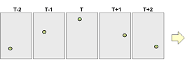
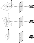
The GeoTime™ visualization technique was developed to improve understanding of movements, events and relationships as they change over time within a spatial context.A combined temporal-spatial space was constructed in which to show interconnecting streams of events over a range of time in a single picture.Events are represented within an X,Y,T coordinate space, in which the X,Y plane shows geographic space and the Z-axis represents time into the future and past (see Figure 1). In addition to providing the spatial context, the ground plan marks the instant of focus between before and after; Events along the timeline "occur" when they meet the surface.Events are arrayed in time along time tracks, which are located wherever events occur within the spatial plane.
 |
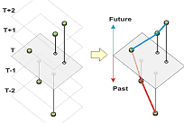 |
Figure 1: Individual frames of movement are translated into a continuous spatiotemporal representation
2.1 Spatial Time-Tracks
Spatial time-tracks make possible the visualization of where and when.They are the primary organizing elements that support the display of events in time and space within a single view.Time-tracks represent a stream of time through a particular Location and are represented as a literal line in space.Each unique location of interest will have one spatial timeline that passes through it.Events that occur at that location are arranged along this timeline according to the exact time or range of time at which the event occurred.
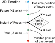 |
Figure 2: 3-D Timeline configured to display past as down and future as up.
A single spatial view will have as many timelines as necessary to show every event at every location within the current spatial and temporal scope.In order to make comparisons between events and sequences of events between locations, the time range represented by the timelines is synchronized.In other words, the time scale is the same for every timeline.
There are three variations of Spatial Timelines that emphasize spatial and temporal qualities to varying extents.These are 3-D Z axis timelines, 3-D viewer facing timelines and linked time chart timelines.Each variation has a specific orientation and implementation in terms of its visual construction and behavior.The user may choose to enable any of the variations at anytime during runtime.
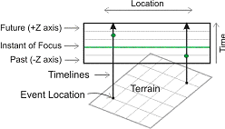
2.2 3-D Z-axis Timelines
3-D Timelines are oriented to the terrain view plane and exist within its coordinate space as shown in Figure 3.
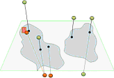 |
Figure 3: 3-D Timelines pass through terrain locations.
3-D Timelines are locked in terrain space and are affected by changes in perspective.
2.3 3-D Viewer Facing Timelines
3-D Viewer-Facing Timelines are similar to 3-D Timelines except that they rotate about the instant of focus point so that they always remain perpendicular to the viewpoint from which the scene is rendered.As illustrated, in Figure 4.
 |
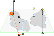 |
Figure 4: Viewer facing timelines rotate to face the viewpoint no matter how the terrain is rotated in 3-D.
2.4 Linked Time-Chart Timelines
Linked Time-Chart Timelines are timelines that connect a 2-D grid in screen space to locations marked in the 3-D terrain representation.As shown in Figure 5, the timeline grid is rendered in screen space as an overlay in front of the 2-D or 3-D terrain.
 |
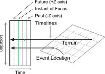 |
Figure 5: Diagram showing how Time-Chart timelines are connected to terrain locations.
3 GeoTime™ Implementation
GeoTime™ has been developed as a Java application and uses the Oculus.Java class library for rendering and animation.Tables of application data are input with a flat file reader, and a Microsoft Access database is used to manage the application data.All three variations of Spatial Timelines have been implemented: 3-D Z Axis Timelines, 3-D Viewer Facing Timelines and Linked Time Chart Timelines.Map data, including 3-D digital terrain elevation data, is accessed via an interface to ESRI / CJMTK (Commercial Joint Mapping Toolkit, www.cjmtk.com) via ArcSDE.A screenshot of GeoTime™ is shown in Figure 6.
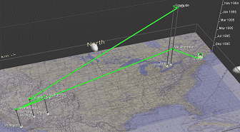 |
Figure 6: Screenshot of GeoTime™ with a moveable time scale at the right.The green line traces a shipment of military supplies
and its movement over time and geography.
Figure 7: As the time slider is moved, a user can see where a shipment of supplies is, where it has been, and where it will be at any given time.
 |
The first commercial version of the GeoTime™ product was released early in 2005.Version two will be released later this fall.
Ed Note: This completes part one.Part two will appear in the October edition of Location Intelligence Magazine.
For more information about GeoTime™ applications contact:
| Dave
Shuping FC Business Systems 703-752-8450 dave.shuping@fcbs.com |
Richard
Brath, Oculus Info Inc., 416-203-3003 Richard.Brath@oculusinfo.com |
Portions of text, all diagrams and all images © 2005 Oculus Info Inc.Reprinted with the permission of Oculus Info Inc.
From Our Homepage
Saying Farewell to an Amazing Journey
Communicating with Maps
Is There a GIS Career Ladder?
What does it mean to be geospatially smart? Series
Ways Real Estate and Property Developers Utilize Melissa GeoData for Data-Driven Decisions
Unlocking Value From Daily Satellite Imagery and Insights
Maximizing the Value of Your Address Data with Geo Addressing
How Indoor Mapping Enhances the Security of Smart Buildings
Look Ahead: AI, Location Intelligence and Efficiency
Collaboration Takes on Sea Level Rise & Dynamic Technology Environments
Brownies for Brownfields
Has Everything Been Mapped Already?
How Is Data Literacy Changing in an Artificial Intelligence Landscape
Portfolios for GIS Professionals: More Than Just Maps
How to Create a Distance Matrix in QGIS - A Step-by-Step Guide
7 Ideas for Bringing GIS into the K-12 Classroom
The Geography of Movement