Current research and future trends in geospatial
application development include collaborative methods for working with
geospatial data.A new term some researchers use to describe this
approach is "geocollaboration." For example, in crisis management
situations such as homeland security or disaster response, teams of
specialists from multiple, disparate organizations often need to share
maps, GPS locations, and related data.They also have a need to
cooperate in making decisions based on the analysis and visualization
of geospatial data.Tools to support geocollaboration can be useful in
enabling an effective, collaborative geospatial decision-making process.
One approach to implementing a geocollaboration tool uses peer-peer (p2p) computing.According to a paper presented at the 2002 IEEE International Conference on System Sciences, "In the future, p2p computing and networking systems for sharing computing resources across more diverse sets of individuals and institutions will need to include more sophisticated capabilities for negotiating and managing sharable resources." In fact, companies like IBM, Sun Microsystems, Microsoft and HP are all working on p2p initiatives to gain maximum advantage of networked computer systems.
Several examples of geocollaborative software tools are reviewed to illustrate the concepts and demonstrate the potential power of this new technology trend.
Background - Identifying the Need
Geospatial Research Initiatives
In Chapter 4 of the book, IT Roadmap to a Geospatial Future, a 2003 publication of the National Academies Press, the topic of Human Interaction with Geospatial Information is discussed in detail.In that book the authors conclude that most research to date on human interaction with geospatial data falls into three domains.
What is Geocollaboration?
In general, the process of collaboration is not well defined and may be thought of as a spectrum - from a low level of interaction and a broad community at one end, to a higher degree of interaction amongst a tighter, more trusted community at the opposite end.The web site, Wikipedia, is an encyclopedia written collaboratively by many of its readers.It illustrates an interesting level of collaboration at the less interactive, open community side of the spectrum.Wikipedia defines collaboration as follows.
One level of collaboration in a geospatial context involves sharing of data and/or applications by and among various organizations.This level of geocollaboration is at the less interactive, open community end of the spectrum and illustrates the trend toward increased awareness of the need for better geocollaboration capabilities.
An example of a collaborative GIS tool that has been developed to support multi-agency cooperative work with geospatial data is the Geospatial One-Stop.It uses the approach of providing portals or channels to various web sites that support sharing of geospatial data and applications.
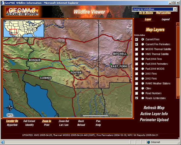
The GOS site is organized by categories such as Fire Mapping.One example of an application that is accessible from GOS is the GeoMAC Wildfire Information website (figure 1).The following description comes from the site.
The need for collaborative work with geospatial data has escalated in recent times due to events such as terrorist activities and natural disasters like the December 2004 tsunami.Some would argue that a higher level of geocollaboration, beyond simply sharing data, is required to support these kinds of efforts.
Advances in Technology
Recent advances in information technology that affect geocollaboration include several areas related to the next generation of computing environments.
Computer-Supported Cooperative Work (CSCW)
Collaboration can be asynchronous, where different people use shared information at different times, or it can be synchronous, where information is shared in real-time.The typical way that synchronous collaboration occurs is during a meeting in which all participants are present."Virtual" synchronous collaboration occurs when participants use technology to enable the real-time sharing of information.Computer technology that supports both synchronous and asynchronous collaboration is sometimes called "groupware."
Most geospatial technology has been developed to support a single user at a time.More research is needed to support group decision-making processes based on geospatial data visualization, especially in a synchronous (real-time) communication mode.There has been little progress made in the realm of commercial software to provide collaborative tools that are integrated with geospatial analysis activities.
Peer-Peer (p2p) Computing
The relatively new concept of peer to peer (p2p) computing provides a system architecture that can help enable real-time geocollaboration.It is now generally accepted that p2p architectures, such as the Microsoft .NET or Sun JXTA environments, allow computers to share information in a more flexible, less restrictive manner.Because of the increasing need for data sharing among distributed systems, on mobile devices, and among dissimilar operating systems, the p2p solution has significant appeal.
The adoption of XML encoded data has helped to drive the adoption of p2p computing by simplifying the transport and delivery of data between heterogeneous systems.There are still some challenges to be addressed, including security concerns and the fear of some IT departments of "losing control" of systems and data that they are responsible for managing.For example, some predict that centralized databases may go away entirely.But for organizations that need to form spontaneous workgroups to respond to an emergency, or to prepare for an impending threat, the p2p approach offers substantial benefits.
Mobile and Distributed Systems
One software solution that utilizes the p2p approach to provide a CSCW environment is Groove Virtual Office from Groove Networks.With the Groove software, users on mobile devices or computers that are not always connected to a network can share data and collaborate on projects.In other words, the Groove product line complements enterprise networks by pushing data out to the edges of those networks using the principles of p2p computing.
The Groove software is a central component in the Bush administration's Homeland Security Information Network - a primary vehicle for federal agencies, and various organizations to share important (unclassified) information about national security threats.
A recent article in Business Week talks about "Combat Over Collaboration," and highlights the head to head competition between IBM and Microsoft to capture market share in this emerging segment of the software industry.Microsoft recently announced its intentions to acquire Groove, and its founder, Ray Ozzie, is the newest CTO at Microsoft.This illustrates the importance that the software industry places on the CSCW trend to enable collaborative information sharing, which some see as the next generation of computing.
Geocollaborative Software Tools
The trend towards a CSCW toolset in the geospatial software industry is evidenced by several different approaches to geocollaboration.
GeoInnovations Project
GeoCAS (Pacific Disaster Center)
According to the PDC web site, "Using the GeoCAS component of IDSS, crisis planners and decision makers have the ability to access a reliable and easy-to-use set of Web-based tools that automatically maps information about hazards (such as hurricane tracks and intensities), overlays the maps with possible impacts to critical facilities (such as roads and hospitals), and provides sharing of other hazard analyses - such as risk and vulnerability assessments, mitigation and preparedness, and planning information.The system is used to monitor events, and is also a valuable tool for education, training, and exercise support."
Toucan Navigate
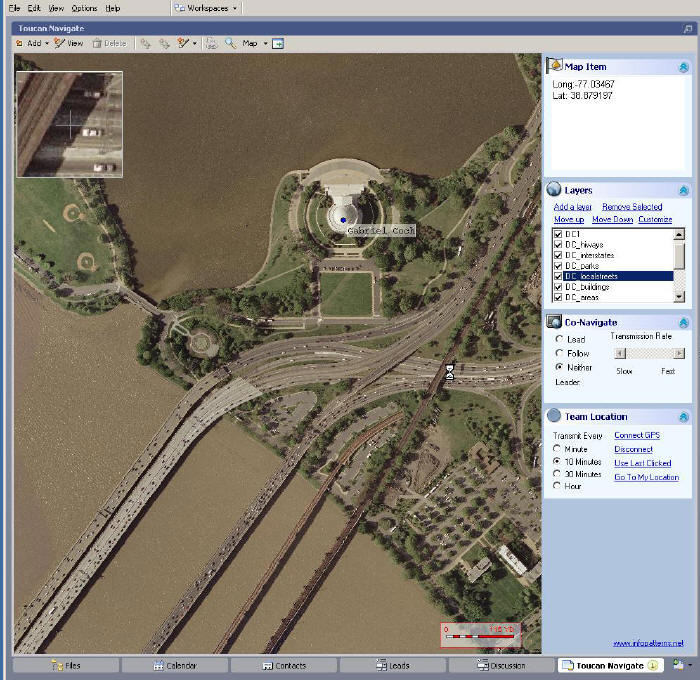
One commercial approach to implementing a p2p software tool that supports geocollaboration is the Toucan Navigate product from Information Patterns.It is a GIS tool that enables real-time collaboration, built on top of the Groove Virtual Office product.
With the Groove approach to collaboration using p2p computing, every computer that is part of the workgroup (i.e.trusted community) acts as a server with the ability to traverse organizational firewalls.The collaborative capabilities include just in time access to vital information that can be shared between all members of the workgroup equally.Toucan Navigate (TN) takes Groove one step further by adding geocollaboration tools.In other words, the TN geospatial tools add one more capability that enables collaborative decision-making within the Groove environment.
An example of this functionality is the ability for everyone to broadcast their location based on a GPS receiver to all other members of the workgroup.All members of the workgroup using TN, no matter where they are physically located, can view the same maps and locations, can add or update both their own locations and the spatial data included in the current view, and can communicate with each other both synchronously (in real time using instant messaging), and asynchronously (by sharing Word documents) using collaboration tools that are included in the Groove suite (figure 2.)
There is an inherent risk in this approach that involves the potential introduction of conflicts - for example, if multiple users happen to make changes to the same data that conflict; or if one person attempts to make edits to the map view at the same time that another person is using the current view for analysis and are unaware of the pending changes.But there are both technical and procedural methods available to minimize such conflicts, and in general, the benefits of a geocollaboration suite of software tools far outweigh the risks.
References
MacEachren, Brewer, Cai, and Chen, 2003, "Visually Enabled Geocollaboration to Support Data Exploration and Decision-Making," Proceedings of the 21st International Cartographic Conference, Durban, South Africa, 10-16 August 2003.
MacEachren, Cai, Sharma, Rauschert, Brewer, Bolelli, Shaparenko, Fuhrmann, and Wang, 2005, "Enabling collaborative geoinformation access and decision-making through a natural, multimodal interface," International Journal of Geographical Information Science, Vol.19, No. 3, pp.293-317.
Hwang, Aravamudham, Liddy, Stanton, and MacInnes, 2002, "IRTL (Information Resources Transaction Layer) Middleware Design for P2P and Open GRID Services", Proceedings of the 36th Hawaii International Conference on System Sciences, IEEE Computer Society.
One approach to implementing a geocollaboration tool uses peer-peer (p2p) computing.According to a paper presented at the 2002 IEEE International Conference on System Sciences, "In the future, p2p computing and networking systems for sharing computing resources across more diverse sets of individuals and institutions will need to include more sophisticated capabilities for negotiating and managing sharable resources." In fact, companies like IBM, Sun Microsystems, Microsoft and HP are all working on p2p initiatives to gain maximum advantage of networked computer systems.
Several examples of geocollaborative software tools are reviewed to illustrate the concepts and demonstrate the potential power of this new technology trend.
Background - Identifying the Need
Geospatial Research Initiatives
In Chapter 4 of the book, IT Roadmap to a Geospatial Future, a 2003 publication of the National Academies Press, the topic of Human Interaction with Geospatial Information is discussed in detail.In that book the authors conclude that most research to date on human interaction with geospatial data falls into three domains.
- Visualization
- Human computer interaction
- Computer-supported cooperative work
What is Geocollaboration?
In general, the process of collaboration is not well defined and may be thought of as a spectrum - from a low level of interaction and a broad community at one end, to a higher degree of interaction amongst a tighter, more trusted community at the opposite end.The web site, Wikipedia, is an encyclopedia written collaboratively by many of its readers.It illustrates an interesting level of collaboration at the less interactive, open community side of the spectrum.Wikipedia defines collaboration as follows.
Collaboration, literally, consists of working together with one or more others.See collaborative software, consensus.The Penn State researchers define the activity of geocollaboration as a group working together to solve geographic problems facilitated by geospatial information technologies.Others view geocollaboration as any form of collaboration that involves geospatial data.
Although the term collaboration is widely used in many varying contexts such as education, science, art and business, very little research has been carried out to discover this process' properties.With the relatively recent advent of computer mediated communication (CMC), the nature of collaboration is coming under more intensive scrutiny.As software designers, facilitators and theorists from many diverse fields strive to create more useful and effective collaborative environments and methods, more light is shown on this ubiquitous and taken for granted practice.However, what light is being cast is still fairly refracted into the diverse fields in which the research is being carried out.Perhaps more collaboration into the nature of collaboration will be required to answer such questions as:
- How does collaboration differ from cooperation? (dictionary definitions are generally more or less equivalent)
- What qualifies as a collaboration? (is Wikipedia a collaboration in the same way that a work of art is when two artist collaborate face-to-face? and for that matter, does a family, city, nation or species qualify?)
- What are the defining principals or elements of this process? (understanding these might help to draw conclusions on the previous questions)
One level of collaboration in a geospatial context involves sharing of data and/or applications by and among various organizations.This level of geocollaboration is at the less interactive, open community end of the spectrum and illustrates the trend toward increased awareness of the need for better geocollaboration capabilities.
An example of a collaborative GIS tool that has been developed to support multi-agency cooperative work with geospatial data is the Geospatial One-Stop.It uses the approach of providing portals or channels to various web sites that support sharing of geospatial data and applications.
The GOS site is organized by categories such as Fire Mapping.One example of an application that is accessible from GOS is the GeoMAC Wildfire Information website (figure 1).The following description comes from the site.
"The Geospatial Multi-Agency Coordination Group or GeoMAC, is an Internet-based mapping tool originally designed for fire managers to access online maps of current fire locations and perimeters in 12 western states. Using a standard web browser, fire personnel can download this information to pinpoint the affected areas."
 |
The need for collaborative work with geospatial data has escalated in recent times due to events such as terrorist activities and natural disasters like the December 2004 tsunami.Some would argue that a higher level of geocollaboration, beyond simply sharing data, is required to support these kinds of efforts.
Advances in Technology
Recent advances in information technology that affect geocollaboration include several areas related to the next generation of computing environments.
Computer-Supported Cooperative Work (CSCW)
Collaboration can be asynchronous, where different people use shared information at different times, or it can be synchronous, where information is shared in real-time.The typical way that synchronous collaboration occurs is during a meeting in which all participants are present."Virtual" synchronous collaboration occurs when participants use technology to enable the real-time sharing of information.Computer technology that supports both synchronous and asynchronous collaboration is sometimes called "groupware."
Most geospatial technology has been developed to support a single user at a time.More research is needed to support group decision-making processes based on geospatial data visualization, especially in a synchronous (real-time) communication mode.There has been little progress made in the realm of commercial software to provide collaborative tools that are integrated with geospatial analysis activities.
Peer-Peer (p2p) Computing
The relatively new concept of peer to peer (p2p) computing provides a system architecture that can help enable real-time geocollaboration.It is now generally accepted that p2p architectures, such as the Microsoft .NET or Sun JXTA environments, allow computers to share information in a more flexible, less restrictive manner.Because of the increasing need for data sharing among distributed systems, on mobile devices, and among dissimilar operating systems, the p2p solution has significant appeal.
The adoption of XML encoded data has helped to drive the adoption of p2p computing by simplifying the transport and delivery of data between heterogeneous systems.There are still some challenges to be addressed, including security concerns and the fear of some IT departments of "losing control" of systems and data that they are responsible for managing.For example, some predict that centralized databases may go away entirely.But for organizations that need to form spontaneous workgroups to respond to an emergency, or to prepare for an impending threat, the p2p approach offers substantial benefits.
Mobile and Distributed Systems
One software solution that utilizes the p2p approach to provide a CSCW environment is Groove Virtual Office from Groove Networks.With the Groove software, users on mobile devices or computers that are not always connected to a network can share data and collaborate on projects.In other words, the Groove product line complements enterprise networks by pushing data out to the edges of those networks using the principles of p2p computing.
The Groove software is a central component in the Bush administration's Homeland Security Information Network - a primary vehicle for federal agencies, and various organizations to share important (unclassified) information about national security threats.
A recent article in Business Week talks about "Combat Over Collaboration," and highlights the head to head competition between IBM and Microsoft to capture market share in this emerging segment of the software industry.Microsoft recently announced its intentions to acquire Groove, and its founder, Ray Ozzie, is the newest CTO at Microsoft.This illustrates the importance that the software industry places on the CSCW trend to enable collaborative information sharing, which some see as the next generation of computing.
Geocollaborative Software Tools
The trend towards a CSCW toolset in the geospatial software industry is evidenced by several different approaches to geocollaboration.
GeoInnovations Project
"GeoConnections is a national partnership initiative working to build the Canadian Geospatial Data Infrastructure (CGDI), and make Canada's geospatial databases, tools and services readily accessible on-line."A research project proposed as part of the Canadian GeoConnections initiative in 2002 included real-time collaboration services for geospatial information. The concept of "geoconferencing" was introduced whereby multiple participants in various locations could collaborate in viewing and editing geospatial data.The participants could share information in a synchronized, geo-referenced workspace.
GeoCAS (Pacific Disaster Center)
"The Pacific Disaster Center's mission is to provide applied information research and analysis support for the development of more effective policies, institutions, programs, and information products for the disaster management and humanitarian assistance communities of the Asia Pacific region and beyond."The Pacific Disaster Center has been developing an Integrated Decision Support System (IDSS).The IDSS is designed to allow humanitarian assistance and disaster management groups to log situational awareness, provide input to planning and analysis models , and gain access to tools, experts, data sources, and organizations in ways that were never before possible.A key component of this system is the Geospatial Collaboration and Awareness System (GeoCAS).The GeoCAS system is based on a distributed data sharing network.
According to the PDC web site, "Using the GeoCAS component of IDSS, crisis planners and decision makers have the ability to access a reliable and easy-to-use set of Web-based tools that automatically maps information about hazards (such as hurricane tracks and intensities), overlays the maps with possible impacts to critical facilities (such as roads and hospitals), and provides sharing of other hazard analyses - such as risk and vulnerability assessments, mitigation and preparedness, and planning information.The system is used to monitor events, and is also a valuable tool for education, training, and exercise support."
Toucan Navigate
One commercial approach to implementing a p2p software tool that supports geocollaboration is the Toucan Navigate product from Information Patterns.It is a GIS tool that enables real-time collaboration, built on top of the Groove Virtual Office product.
With the Groove approach to collaboration using p2p computing, every computer that is part of the workgroup (i.e.trusted community) acts as a server with the ability to traverse organizational firewalls.The collaborative capabilities include just in time access to vital information that can be shared between all members of the workgroup equally.Toucan Navigate (TN) takes Groove one step further by adding geocollaboration tools.In other words, the TN geospatial tools add one more capability that enables collaborative decision-making within the Groove environment.
An example of this functionality is the ability for everyone to broadcast their location based on a GPS receiver to all other members of the workgroup.All members of the workgroup using TN, no matter where they are physically located, can view the same maps and locations, can add or update both their own locations and the spatial data included in the current view, and can communicate with each other both synchronously (in real time using instant messaging), and asynchronously (by sharing Word documents) using collaboration tools that are included in the Groove suite (figure 2.)
 |
There is an inherent risk in this approach that involves the potential introduction of conflicts - for example, if multiple users happen to make changes to the same data that conflict; or if one person attempts to make edits to the map view at the same time that another person is using the current view for analysis and are unaware of the pending changes.But there are both technical and procedural methods available to minimize such conflicts, and in general, the benefits of a geocollaboration suite of software tools far outweigh the risks.
References
MacEachren, Brewer, Cai, and Chen, 2003, "Visually Enabled Geocollaboration to Support Data Exploration and Decision-Making," Proceedings of the 21st International Cartographic Conference, Durban, South Africa, 10-16 August 2003.
MacEachren, Cai, Sharma, Rauschert, Brewer, Bolelli, Shaparenko, Fuhrmann, and Wang, 2005, "Enabling collaborative geoinformation access and decision-making through a natural, multimodal interface," International Journal of Geographical Information Science, Vol.19, No. 3, pp.293-317.
Hwang, Aravamudham, Liddy, Stanton, and MacInnes, 2002, "IRTL (Information Resources Transaction Layer) Middleware Design for P2P and Open GRID Services", Proceedings of the 36th Hawaii International Conference on System Sciences, IEEE Computer Society.
From Our Homepage
Saying Farewell to an Amazing Journey
Communicating with Maps
Is There a GIS Career Ladder?
What does it mean to be geospatially smart? Series
Ways Real Estate and Property Developers Utilize Melissa GeoData for Data-Driven Decisions
Unlocking Value From Daily Satellite Imagery and Insights
Maximizing the Value of Your Address Data with Geo Addressing
How Indoor Mapping Enhances the Security of Smart Buildings
Look Ahead: AI, Location Intelligence and Efficiency
Collaboration Takes on Sea Level Rise & Dynamic Technology Environments
Brownies for Brownfields
Has Everything Been Mapped Already?
How Is Data Literacy Changing in an Artificial Intelligence Landscape
Portfolios for GIS Professionals: More Than Just Maps
How to Create a Distance Matrix in QGIS - A Step-by-Step Guide
7 Ideas for Bringing GIS into the K-12 Classroom
The Geography of Movement