 |
Today, public health professionals, researchers, policy makers and many others are increasingly using GIS to understand the spatial and environmental factors that affect health outcomes, disease transmission, disaster response, access to health care and a myriad of other health concerns. A common theme among many of these concerns surrounds the links between the spatial locations of occurrences to a suspected source (e.g., clusters of cancer incidence rates in proximity to a toxic waste site). Intuitively this approach makes very good sense, especially if you are trained as a geographer or epidemiologist. The importance of geography and the environment in health is receiving a great deal of attention in the media; the spread of the West Nile virus, environmental inequality issues and the potential for an Avian flu pandemic have all raised the level of fear in the average American and the officials who govern them.
Researchers in GIScience are using a much more holistic "eye” when interpreting the correlation of health data and their spatial distribution. Consider this scenario. A medical geographer using trend surface analysis in GIS discovers that prostate cancer incidence rates increase with increasing latitude. She has the who, what and where, but not the why. On another score, a cancer biologist conducts a clinical trial and discovers that Vitamin D plays an important biochemical role in the prevention of prostate cancer. He holds the answer to her why, but doesn’t realize it. Later, the two researchers meet by chance and begin to discuss their work. Could it be that the amount of sunlight exposure is related to latitude? And that this exposure results in the manufacture of Vitamin D in humans which in turn prevents prostate cancer in men? She now has her why!
This "scenario" mentioned above not only led to a number of other studies, but it also provided partial impetus for the establishment of the Center for Geographic Information Science and Health in the Department of Geography at the University of North Carolina Greensboro. The center provides a unique research and educational environment for understanding and maintaining the health of the human population through the concepts and applications of GIScience. Launched in the spring of 2006, the initial funding for the Center came from the University of North Carolina Greensboro and is supported by several external grants and contracts. Over a dozen faculty from the departments of Geography, Public Health, Anthropology and Sociology, are involved in the Center’s activities. Importantly, the Center provides students from Geography’s masters and doctoral programs the opportunity to work as members of an interdisciplinary research team in addressing significant health and disaster planning issues. For more information, contact Dr. Rick Bunch, Director.
Individuals associated with the center have conducted a number of collaborative efforts with health professionals and officials throughout the State of North Carolina. These activities include educational sessions on GIS, focusing on concepts and appropriate methodologies, and not simply "button pushing." These sessions are designed to avoid the pitfalls often derived from "drive-by" GIS where individuals have very little understanding of the geographic concepts underlying the appropriate collection, analysis, and display of spatial data. As a result, frequently much money, time and effort has been expended to achieve at best a simplistic understanding of the role of space and the environment on health issues, or at worst has directed health officials to make erroneous conclusions. The goal of the new Center for GIScience and Health is to institutionalize GIScience within the culture of health researchers and professionals by offering repetitive exposure, content depth, context and continual GIS support once sessions are complete.
Individuals from the center have also helped develop GIS methods for rapid needs assessment. This method randomly locates points in randomly selected block groups in an impacted area. The point locations are spatially joined with street centerlines and given an address. Interviewers armed with mobile GIS units with prepared forms are sent to the address sites to ask household members a series of questions designed to assess their needs. The major needs can be determined and alleviated through supply deployment. This methodology was successfully tested in April of 2006 in a pilot study along portions of Hancock and Harrison County, Mississippi, that were ravaged by Hurricane Katrina. The exercise showed that vitally needed information could be acquired rapidly, accurately and at a relatively low cost using GIS. Interestingly, interviewers discovered that diapers were the most commonly requested item. After Katrina, the need for a comprehensive picture of what were the needs of those on the ground in the days following the disaster was painfully obvious. Disaster response officials frustrated by the "blindness" of no data repeatedly stated "we don’t know any more than what we see on CNN."
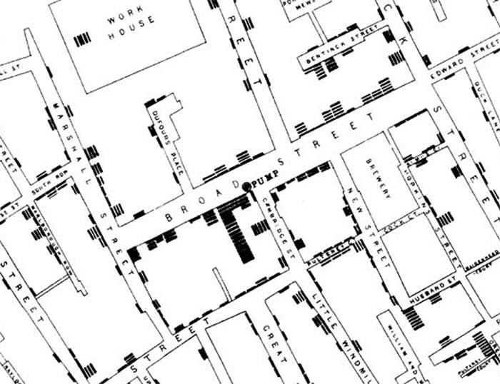
Collaborative endeavors of geographers and health researchers should provide a rich laboratory where ideas, information, skills and technologies can be exchanged and brought to bear on the health problems plaguing the human population. From geography to the gene, collaborations such as those being formed in the new Center may produce the team that shows this generation of public officials which pump handle to remove.
From Our Homepage
Saying Farewell to an Amazing Journey
Communicating with Maps
Is There a GIS Career Ladder?
What does it mean to be geospatially smart? Series
Ways Real Estate and Property Developers Utilize Melissa GeoData for Data-Driven Decisions
Unlocking Value From Daily Satellite Imagery and Insights
Maximizing the Value of Your Address Data with Geo Addressing
How Indoor Mapping Enhances the Security of Smart Buildings
Look Ahead: AI, Location Intelligence and Efficiency
Collaboration Takes on Sea Level Rise & Dynamic Technology Environments
Brownies for Brownfields
Has Everything Been Mapped Already?
How Is Data Literacy Changing in an Artificial Intelligence Landscape
Portfolios for GIS Professionals: More Than Just Maps
How to Create a Distance Matrix in QGIS - A Step-by-Step Guide
7 Ideas for Bringing GIS into the K-12 Classroom
The Geography of Movement