Current asset management
Asset management systems
available today provide comprehensive capabilities for managing government
infrastructure inventories for assets such as water systems, wastewater
systems, signage, meters, and equipment.These systems enable organizations
to collect asset information, track asset status and maintenance history,
analyze asset performance, and generate reports.Typically, these are tabular
database applications with powerful query and reporting capabilities.They
often link to customer billing systems, work management systems, or analysis
packages for specific tasks.The key benefit for government organizations
is the ability to improve the understanding and management of their asset
inventory.
Many managed assets are located across large geographical areas and thus could benefit from the inclusion of a geospatial component.These systems need a "picture" of the real world to unlock their full power for discovery, analysis, operations, and planning. Efficient management of an asset must include location information to ensure good decisions are made relative to the surrounding area and effected assets. For example, an organization may want to know what assets are located near a specific asset at a street intersection.This is especially true for underground assets since you don't want to hit a water pipeline when digging for a cable.This simple requirement can be relatively hard to meet in tabular systems, depending on the way assets are related to street addresses. However, performing a spatial proximity search for assets within or near the street intersection quickly and easily provides the necessary information.
By geospatially enabling asset management, users can easily visualize and understand the geographic context of an asset and find other assets located close by.This capability enables organizations to make better operational decisions and easily communicate proposed or actual asset improvements.
Similarly, when selecting assets for an operation - for instance a water main flushing or an inspection - the ability to spatially select assets greatly simplifies the task.It is far more difficult and time consuming to select an asset by unit ID or proximity to an address than to simply select a point on a map and click. This may seem like a small increase in efficiency, but spread over months and years, these small time savings can equal a big savings for the work force and the organization.
Integrating geospatial
technology with asset management
So how do you go about integrating
your asset management systems with geospatial technology? Asset management
systems have traditionally offered geospatial technology and data by embedding
GIS components or by using inter-process communication between applications.
This approach created a "tight" integration between heavy-duty system components,
resulting in specific software dependencies.These types of systems were
more difficult to develop, support, and administer.As the GIS components
or asset management components changed, direct interfaces had to be updated.
This also limited users to specific GIS components and specific asset management
systems.
Integration approaches are moving from contained GIS components and interprocess communication to Web Services architectures.Web Services use standard communication protocols between business applications and thus maximize flexibility and modularity in supporting the software integration.The Web Services protocols can be published to allow other business applications to take advantage of these capabilities.This creates a "loosely coupled" integration, which makes the resulting systems easier to develop, implement, and support.
Let's look at an example of integrating geospatial capabilities with asset management using Web Services.Suppose a user wishes to do a simple search of any assets within a proximity distance of a selected asset and would like to visualize the results.For example, if a water line has a problem, it is important to understand all other assets within the immediate area.The query from the asset management system issues a request to a geospatial query Web Service via an URI.This URI directs the request to a Web Server, which performs the spatial query against warehouses of geospatial information.A map is generated showing the selected water line, the immediate area, and any nearby assets.A URI location of the resulting map is returned from the Web Service to the asset management system.Finally, the asset management system gets the generated map from the URI and displays the answer.Figure 1 illustrates the architecture of this Web Service, and Figure 2 shows a screenshot from this workflow.

Figure 1. A geospatial
query Web Service is used to provide proximity searches to the asset management
system.The geospatial technology is used to perform the geospatial query.
Click image for larger
view.
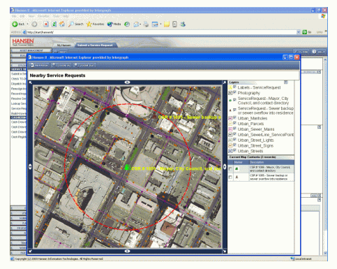
Figure 2. Screenshot
of the Hansen Asset Management system showing the results of the geospatial
query.
Click image for larger
view.
Asset management systems
can benefit by the inclusion of geospatial data and technology.Integrating
geospatial information improves the ability to manage, visualize, analyze,
and communicate information about asset inventory.While this integration
can be accomplished using embedded components and interprocess communication
between applications, Web Services can now be built to make the resulting
systems easier to develop, implement, and support.Web Services are clearly
part of the future when geospatially enabling business systems such as
asset management.Using Web Services will decrease the cost of deployment
and ultimately increase an organization's return on investment in geospatial
technology.