The United States Geological Survey (USGS) this week
announced (press
release) an update to Geospatial
One-Stop (GOS), the federal government portal for geographic data,
services and more. This is the first time the site has been in the news
for some time.
The update provides an opportunity for those in the geospatial community to revisit the site, see what's new and see how the portal can help in day-to-day work. The update reflects changes in data querying, query results and how they are delivered, and further information about the services the site indexes.
What's New in Querying?
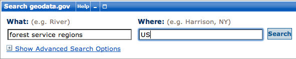
Within the Help Center tab at Geodata.gov is a document titled "What's New in Geospatial One-Stop (GOS) Version 2.3." It details changes relevant to three different user groups: users, publishers and administrators. I focus here on changes specifically aimed at users. I used as an example a query noted on Twitter: the individual sought a shapefile of U.S. Forest Service Regions. (Figure 1).
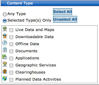
One of the new features appears in the second step of the query process; it filters via icons the type of content of interest. The options include Live Data and Maps, Downloadable Data, Services and Applications, among others (Figure 2). The previous implementation of this part of the search was a bit more hidden. Further, one of the options, Geographic Activities, was renamed Planned Data Activities to make it clear that such data were not yet available. It'd be nice to see each type of content with a link (or mouse over) that provides an expanded definition. A second new filter option provides the ability to select metadata by collections. The current options include Geodata.gov, Marketplace, GIS Inventory (Ramona) and options for coastal data. While some of these collections are self-explanatory, some such as GIS Inventory are not likely to be familiar to all visitors and, like the types of content, would benefit from further descriptive information. Other collections noted in the "What's New" document, including The National Map, do not appear in the collections list.
What's New in Results?
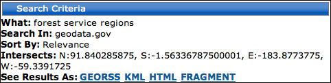
Once I executed my query, more new features of GOS appeared. A review of search criteria (Figure 3) showed what I searched, where I searched (collections or in my case, no collections), the search's bounding box, and the option to see my results in GeoRSS, KML, HTML or fragment (defined in the "What's New" document as "a snippet of HTML"). I tried to view the 93 results in each format. None were successfully created on my Mac (Mac OSX, Safari), though all four appeared in my Windows machine (Win XP, Firefox). According to the "What's New" document, these tools use "the REST API" and allow "search results to be exposed in external applications, such as RSS Readers, HTML pages and KML readers such as Google Maps and Google Earth." Users have been able to sign up for e-mail updates when new data appear that match a saved query. These e-mail messages now include GeoRSS and KML links.
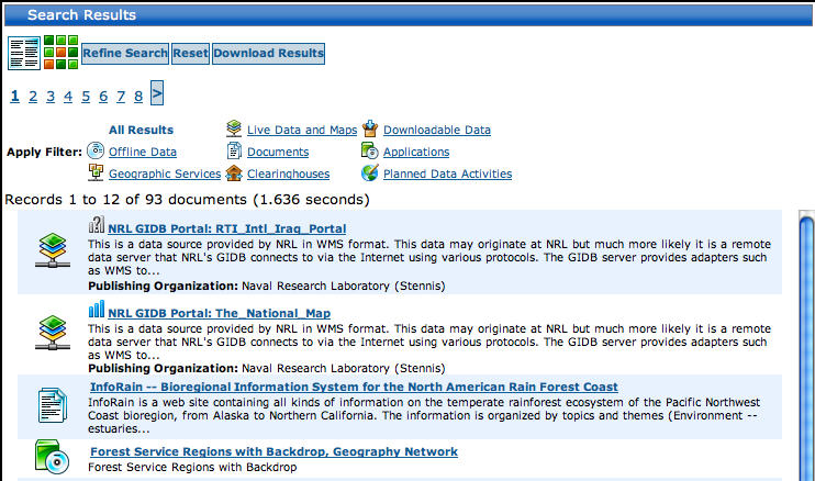
The results of my query were coded using the icons of the content type filters (Figure 4). I think making the current content type filter a bit more prominent would be helpful; the bold text of the current filter was not as prominent as it might have been among the colorful icons.
What's New in Service Availability?
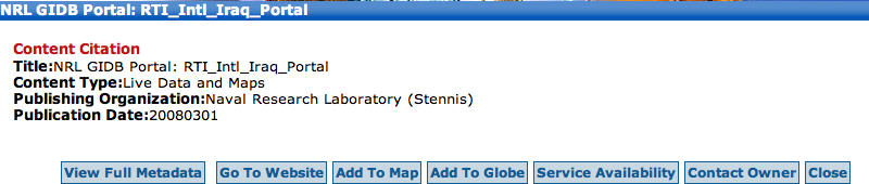
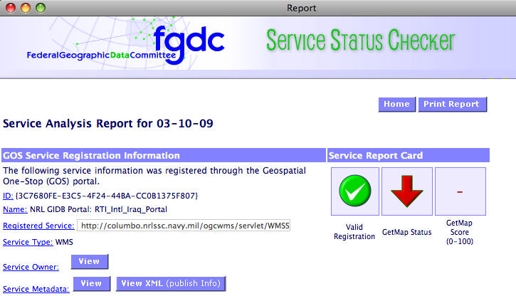
I clicked on the best match I saw for my query, which was a link to the Geography Network, but I found that resource unavailable. Had I been looking for Live Data and Maps (the Geography Network is an application), I'd have run into another new feature, a status check (Figure 5). A Service Availability button on the resource's metadata page taps into the Federal Geographic Data Committee (FGDC) Service Status Checker and returns a status update. In my case, the status for a Web Map Service (WMS) from the Naval Research Lab was, in short, "down" (Figure 6). Of the five Live Maps and Data results returned, just one had its GetMap (one of the WMS services) "up." That WMS was from the VT Center for Geographic Information.
The integration with the FGDC Service Status Checker is a true winner from my perspective. There is nothing worse (and my students will back me up here!) than finding just the right service and it being unavailable. Further, this check of standards-based services like WMSs confirms for new users that the server is at fault (though of course there may be other factors in a failed connection). I'm hopeful that since the Contact Owner button is right next to the Service Availability button, users will not hesitate to make contact when a service is down. I'd like to think hosts of such services monitor them to see when they go down, but if not, here's another easy way to do so.
Two other updates are noted for end users, including enhancements to the Statistics Tab and an update to the Maps Tab. New stats include:
The updated Maps tab provides access to maps by theme (basemaps, environment, geology) and scale (national, state, local). There's also an option to visit Map Stores like the USGS Store, The National Atlas and The Federal Aviation Administration (FAA). I'm not sure "Map Stores" is the best term for these; I suggest these are "government map providers."
The other new features are aimed at data publishers and geodata website administrators. They include:
The updates for end users, specifically those that access filters and information about service availability, are valuable additions. Just as enhancements to consumer mapping portals rarely drive huge amounts of new traffic to a site, a few changes are not likely to convince longtime non-users to head to Geodata.gov in droves. Still, each enhancement is a step in the right direction.
The update provides an opportunity for those in the geospatial community to revisit the site, see what's new and see how the portal can help in day-to-day work. The update reflects changes in data querying, query results and how they are delivered, and further information about the services the site indexes.
What's New in Querying?
Within the Help Center tab at Geodata.gov is a document titled "What's New in Geospatial One-Stop (GOS) Version 2.3." It details changes relevant to three different user groups: users, publishers and administrators. I focus here on changes specifically aimed at users. I used as an example a query noted on Twitter: the individual sought a shapefile of U.S. Forest Service Regions. (Figure 1).
 |
One of the new features appears in the second step of the query process; it filters via icons the type of content of interest. The options include Live Data and Maps, Downloadable Data, Services and Applications, among others (Figure 2). The previous implementation of this part of the search was a bit more hidden. Further, one of the options, Geographic Activities, was renamed Planned Data Activities to make it clear that such data were not yet available. It'd be nice to see each type of content with a link (or mouse over) that provides an expanded definition. A second new filter option provides the ability to select metadata by collections. The current options include Geodata.gov, Marketplace, GIS Inventory (Ramona) and options for coastal data. While some of these collections are self-explanatory, some such as GIS Inventory are not likely to be familiar to all visitors and, like the types of content, would benefit from further descriptive information. Other collections noted in the "What's New" document, including The National Map, do not appear in the collections list.
 |
What's New in Results?
Once I executed my query, more new features of GOS appeared. A review of search criteria (Figure 3) showed what I searched, where I searched (collections or in my case, no collections), the search's bounding box, and the option to see my results in GeoRSS, KML, HTML or fragment (defined in the "What's New" document as "a snippet of HTML"). I tried to view the 93 results in each format. None were successfully created on my Mac (Mac OSX, Safari), though all four appeared in my Windows machine (Win XP, Firefox). According to the "What's New" document, these tools use "the REST API" and allow "search results to be exposed in external applications, such as RSS Readers, HTML pages and KML readers such as Google Maps and Google Earth." Users have been able to sign up for e-mail updates when new data appear that match a saved query. These e-mail messages now include GeoRSS and KML links.
 |
The results of my query were coded using the icons of the content type filters (Figure 4). I think making the current content type filter a bit more prominent would be helpful; the bold text of the current filter was not as prominent as it might have been among the colorful icons.
 |
What's New in Service Availability?
I clicked on the best match I saw for my query, which was a link to the Geography Network, but I found that resource unavailable. Had I been looking for Live Data and Maps (the Geography Network is an application), I'd have run into another new feature, a status check (Figure 5). A Service Availability button on the resource's metadata page taps into the Federal Geographic Data Committee (FGDC) Service Status Checker and returns a status update. In my case, the status for a Web Map Service (WMS) from the Naval Research Lab was, in short, "down" (Figure 6). Of the five Live Maps and Data results returned, just one had its GetMap (one of the WMS services) "up." That WMS was from the VT Center for Geographic Information.
 |
 |
The integration with the FGDC Service Status Checker is a true winner from my perspective. There is nothing worse (and my students will back me up here!) than finding just the right service and it being unavailable. Further, this check of standards-based services like WMSs confirms for new users that the server is at fault (though of course there may be other factors in a failed connection). I'm hopeful that since the Contact Owner button is right next to the Service Availability button, users will not hesitate to make contact when a service is down. I'd like to think hosts of such services monitor them to see when they go down, but if not, here's another easy way to do so.
Two other updates are noted for end users, including enhancements to the Statistics Tab and an update to the Maps Tab. New stats include:
- number of metadata records in GOS (211,114, as of March 5)
- number of records for each content type (geographic services, 20)
- number of publishers (with at least one record, 6,139)
- most accessed metadata records are identified (Mississippi and Ohio River Polygon)
The updated Maps tab provides access to maps by theme (basemaps, environment, geology) and scale (national, state, local). There's also an option to visit Map Stores like the USGS Store, The National Atlas and The Federal Aviation Administration (FAA). I'm not sure "Map Stores" is the best term for these; I suggest these are "government map providers."
The other new features are aimed at data publishers and geodata website administrators. They include:
- tools to configure the GOS metadata harvesting interface and view harvesting history
- the ability to register multiple WMS service layers in a single service with ease
- an update to the federal government list in publisher profiles - federal publishers can attach an agency name to each metadata record (for example, Dept. of Agriculture, Dept. of Commerce)
The updates for end users, specifically those that access filters and information about service availability, are valuable additions. Just as enhancements to consumer mapping portals rarely drive huge amounts of new traffic to a site, a few changes are not likely to convince longtime non-users to head to Geodata.gov in droves. Still, each enhancement is a step in the right direction.
From Our Homepage
Saying Farewell to an Amazing Journey
Communicating with Maps
Is There a GIS Career Ladder?
What does it mean to be geospatially smart? Series
Ways Real Estate and Property Developers Utilize Melissa GeoData for Data-Driven Decisions
Unlocking Value From Daily Satellite Imagery and Insights
Maximizing the Value of Your Address Data with Geo Addressing
How Indoor Mapping Enhances the Security of Smart Buildings
Look Ahead: AI, Location Intelligence and Efficiency
Collaboration Takes on Sea Level Rise & Dynamic Technology Environments
Brownies for Brownfields
Has Everything Been Mapped Already?
How Is Data Literacy Changing in an Artificial Intelligence Landscape
Portfolios for GIS Professionals: More Than Just Maps
How to Create a Distance Matrix in QGIS - A Step-by-Step Guide
7 Ideas for Bringing GIS into the K-12 Classroom
The Geography of Movement