 November
17th was the third in a series of seminars held by ESRI and IBM for
Federal managers.The objectives were of the increasing collaboration
between agencies, developing more decision making power and expanded
use of current and evolving technologies.There were basically three
parts of the program: the identification and scope of the ESRI/IBM
relationship and the vision and evolution of ESRI software, a
presentation about enterprise data sharing from the CDC and the view
from IBM of Creating a GIS Integrated Enterprise, and building and
maintaining an enterprise.
November
17th was the third in a series of seminars held by ESRI and IBM for
Federal managers.The objectives were of the increasing collaboration
between agencies, developing more decision making power and expanded
use of current and evolving technologies.There were basically three
parts of the program: the identification and scope of the ESRI/IBM
relationship and the vision and evolution of ESRI software, a
presentation about enterprise data sharing from the CDC and the view
from IBM of Creating a GIS Integrated Enterprise, and building and
maintaining an enterprise.The ESRI perspective came from a Jack Dangermond video speaking about the evolution of GIS toward server based applications and moving from static maps to real-time visualization.The concept of server sourced information that could expand beyond the desktop, merge with it or just a thin client (e.g.your browser).All of these mediums should access common data sources seamlessly to enable the enterprise evolving to data sharing as a "societal" experience.
An example of a server based government application/data source was the GeoSpatial One Stop and the ability to search by address or location for Katrina storm damage.
The key was to move to a system of systems, server(s), data and applications all loosely coupled, but connected.This movement needed to be facilitated by:
Standardization of data models
GIS Portals
A Network of Providers (data & apps)
Collaborative agreements
Leadership in both Organization and Technology
All of this should be built on Service Orientated Architecture that has"¦
More bandwidth
Open systems
Faster processing
Larger storage
In short, more of everything.
Perhaps the most technically interesting was the presentation by IBM's Christopher Couper, Distinguished Engineer and CTO, where he brought together the concepts of Business Intelligence and GIS.Most importantly was that he introduced a term that brings together these technologies with real time visualization, in what he referred to as "STC" or Spatial Temporal Computing.STC was the means to not only see things in real time, but to be able to look backward and forward through the temporal modeling of events and conditions within the enterprise.
STC is effectively already being applied in the supply chain and the use of RFID .
The concept is to introduce time as an equal partner with GIS and BI in order to properly manage the enterprise.IBM and ESRI have recognized that BI must integrate with spatial functionality and that spatial functionality is incomplete without temporal understanding, predictive analytics and modeling.
Mr.Couper had six phases of moving the enterprise to solution maturity (BI, GIS and STC).
The basics of the phases were (excerpts from presentation slides);
1. Phase 1 ï¿1⁄2" Catalog Details ï¿1⁄2" catalogs, collect and stores spatiotemporal data (3D space & time) for stationary
assets.
2. Phase 2 ï¿1⁄2" Track Details ï¿1⁄2" track spatiotemporal and other attributes for assets that move.
3. Phase 3 ï¿1⁄2" Monitor & Alert Details ï¿1⁄2" monitors the location of both stationary and mobile assets and their relationship
to each other and to their surroundings.
4. Phase 4 ï¿1⁄2" Visualize and Interact Details ï¿1⁄2" Visualizes the information gathered in the prior three phases.
5. Phase 5 ï¿1⁄2" Automate Metrics ï¿1⁄2" Combines phases 1 ï¿1⁄2" 4 with metrics for optimal operations and to automatically adjust
the current operations.
6. Phase 6 ï¿1⁄2" Analyze/Model/Predict Details ï¿1⁄2" analyzes the information gathered and acted upon in each of the previous
phases ï¿1⁄2" includes predictive analytics, modeling and simulation to predict the future and then plan accordingly.
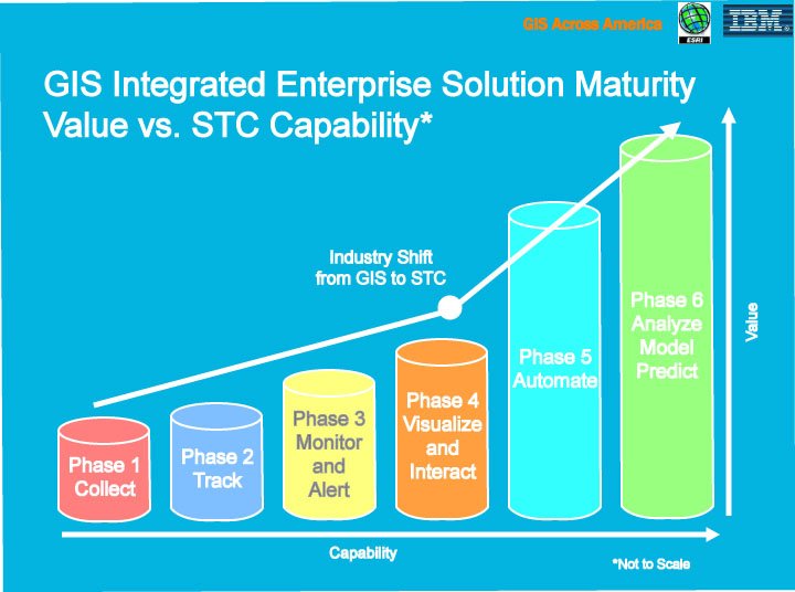
Click
for larger image (Image based on seminar handouts)
.The temporal piece, or the 4th dimension, completes the sphere of understanding necessary to run a comprehensive enterprise.Without it, you can know the Who, What and Where, but not the When.
From Our Homepage
Saying Farewell to an Amazing Journey
Communicating with Maps
Is There a GIS Career Ladder?
What does it mean to be geospatially smart? Series
Ways Real Estate and Property Developers Utilize Melissa GeoData for Data-Driven Decisions
Unlocking Value From Daily Satellite Imagery and Insights
Maximizing the Value of Your Address Data with Geo Addressing
How Indoor Mapping Enhances the Security of Smart Buildings
Look Ahead: AI, Location Intelligence and Efficiency
Collaboration Takes on Sea Level Rise & Dynamic Technology Environments
Brownies for Brownfields
Has Everything Been Mapped Already?
How Is Data Literacy Changing in an Artificial Intelligence Landscape
Portfolios for GIS Professionals: More Than Just Maps
How to Create a Distance Matrix in QGIS - A Step-by-Step Guide
7 Ideas for Bringing GIS into the K-12 Classroom
The Geography of Movement