At each GIS-T meeting two key reports are published: the Summary of State DOT GIS Activities and the Roll Call of States. The Summary of State DOT GIS Activities is a comprised of the results of a survey issued to each state by the FHWA. The GIS managers of the state DOTs are asked to respond to a series of questions related to their organizations, software deployments, cost/benefits and currently active projects. The Roll Call of States is a quick synopsis of the project priorities of each state or province and the issues about which they are most concerned. For the purposes of this article, each report will be summarized. At the end of each summary, a link to the full report will be provided.
The Summary of State DOT GIS Activities
Bruce Spear, recently retired from the FHWA and now with Cambridge Systematics, summarized the results of the State DOT GIS Activities report. For the first time, all 50 states responded to the survey, which was conducted entirely online. One key question that was added to this year's survey required states to acknowledge whether they had put a GIS strategic plan in place. All but six reported that they had a plan in place.
Organization and Staffing
States that maintain a core GIS unit, that is, an organization specifically dedicated to GIS within the DOT and which supports other DOT divisions, continue to be the most common type (55% of the DOTs) of organizational unit. Less prevalent (25%) is an organizational structure that integrates GIS throughout DOT divisions, which the report identifies as an "enterprise GIS" approach. The GIS core units typically report either through the DOT planning (34%) division or the information services (33%) division.
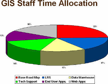
With regard to staffing, GIS departments consist of, on average, seven or eight professionals, while DOTs outsource about 40% of their GIS work. The GIS staff expertise usually consists of those with geography or cartography backgrounds and 21% of DOTs report having a certified GIS professional on staff. However, only 12% of the DOTs report that GIS certification will be a factor in the future and 23% are undecided. The time allocation of staff members is split among six core functions. See the graph below:
 |
GIS Software in Use
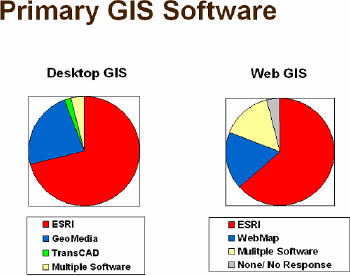
Spear cited that only eight DOTs consider themselves to be exclusive one-vendor software shops, all of those being ESRI. This is down from 13 "exclusively ESRI states" reported last year. The greatest increase is in states reporting two vendors, which jumped from 12 in 2006 to 21 this year. Many of these states identify [Bentley] MicroStation as the second vendor, along with ESRI. For the GIS core units using desktop GIS software, ESRI is used by 71% of the DOTs, Intergraph by 23%. For Web applications, the distribution is 63% ESRI ArcIMIS, while Intergraph's GeoMedia WebMap is used by 25% (see the figure below for more details). For database software, Oracle is used by 50% of the DOTs, while Microsoft SQL Server is used by 25%. Of those using a spatial database management solution, ArcSDE is used by a majority, while Oracle Spatial is used by approximately 13% of the DOTs.
 |
Base Map Scales and Road Network Coverage
DOTs continue a movement to higher resolution map scales, with more than 50% of them stating that they maintain base maps at a scale of 1:5,000 or higher. Very few are at a scale smaller than 1:24,000. All states are now maintaining a digital road centerline database and 73% say they are distributing the data free of charge to whatever public agency wants them. Seventy-five percent of DOTs are now "the keepers" of spatial data beyond transportation network features and 20% report maintaining the geodetic control for the state.
Summary
The states report that the greatest benefit of GIS technology is the ability to tie all of the data together in an enterprise environment, but this is also their greatest challenge, followed closely by CAD/GIS integration.
Web-based applications continue to grow, with significant activity spent on software updating and migration as well as the integration of imagery.
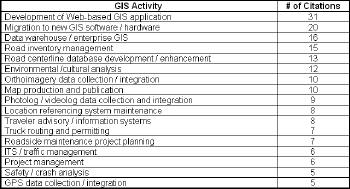
As a review of the statewide GIS activities, the following table provides a brief synopsis of the key projects cited as priorities:
 |
The Summary of State DOT GIS Activities -Diagrams and data (pdf)
The Summary of State DOT GIS Activities -Narrative and Summary (pdf)
The Roll Call of States
Frank Winters of the New York State Office of Cyber Security and Critical Infrastructure Coordination presided over the Roll Call of States. While the complete report (pdf) can be viewed in its entirety, some interesting anecdotes were delivered by those representing each state. Below are a representative few.
Tennessee - The biggest area is assuming and working with state GIS office and developing a common, consolidated road geometry.
Virginia - 511 Virginia is a Virtual Earth and ESRI hybrid.
Washington - Linear Reference System (LRS) updates are a constant struggle and they are concerned with CAD/GIS integration.
Wyoming - GIS will be the front end of the operations for the new Transportation Management Center.
California - An enthusiastic Oscar Jarquin is putting an emphasis on developing with open source solutions and announced that their Traveler Information Map was developed with open source stack. And he is willing to offer this solution to any other state that wants to use it.
Idaho - David Fulton, a self-professed "non-GIS guy," said, "All I did was get SDE Server to work like it's supposed to."
Indiana - They are moving through legislation to create an office of GIS.
Iowa -They are looking to start a statewide LiDAR project.
Maine -They will be integrating their Oracle business intelligence platform with GIS.
Michigan -They are undertaking a huge project involving all of the state agencies and implementation of Oracle Spatial.
Minnesota -They have moved a lot of data to spatial data warehouses. They are also moving GIS to a services-oriented architecture (SOA).
Mississippi - A new division was formed within the state: Transportation Information Division.
Montana -They are seeking funding strategies.
Nebraska -They want to know how people are using Google Earth.
New York -Their big project: modernization between highway data and street centerline data.
Oregon -They are interested in mixed GIS environments of ESRI and GeoMedia.
South Carolina -They are asking: how are people using Google Earth?
Canadian Provinces
The Ministry of Transportation Ontario is working to spatially enable its business data.
Prince Edward Island has a one-person GIS staff but has completed the LRS for all roads with a complete inventory of all road features.
Manitoba has Intergraph-based applications and is interested in Oracle Spatial data but will be using Google Earth.
Summary
There are many states wresting with the spatial data management systems and several cite CAD/GIS integration as an ongoing concern. Imagery is playing a larger part of data management and video logging seems less a priority than in past years. While the work of maintaining an accurate road centerline is still a high priority, the development of Web-based applications to share this information is cited by more states (31) than any other type of ongoing project.
Roll Call of States - Complete report (pdf)