The history of GIS dates back roughly 50 years to a
time when thematic maps were drawn or plotted on translucent film, then
physically laid on top of each other to create a composite image. In
the last five decades, GIS technology has evolved from a
labor-intensive physical pursuit to one that operates with powerful
software-based systems.
A data collection revolution
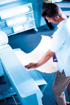
GIS data capture can come from remote sensing and surveying, or it can be derived from non-digital sources through digitization and scanning. Data collection and conversion has traditionally been the most expensive and time-consuming aspect of GIS projects.
The tablet digitizing process historically existed as an acceptable method for creating data points with x and y values. However, this time-draining process was often fraught with challenges - difficulty using the digitizing puck, tablet malfunctions, source materials changing size, registration problems, edge-matching complexity and more. Those days are drawing to a close.
With today's more advanced digitizing methods, it is now possible to scan in a map, bring the scanned map into a GIS, georeference the scanned map, zoom in on the screen and digitize select features. This revolution in technology means users can zoom in on images as much as is needed, digitize using a computer mouse, and more easily edge-match for faster map creation.
Scanner choices and considerations
The convergence of GIS and scanning presents users with a myriad of choices, the most important being which type of scanning technology to use - reduction type or contact image sensor.
Reduction type scanning is similar to the technology used in a traditional camera. An image is reduced through a single camera lens and focused on a sensor, which captures the image based on intensity of light passing through the lens. This creates images of much higher quality than contact image technology; however, since scanners are typically separate from the printing system, it requires a larger footprint. This is most often used for applications where quality is at a premium.
In contact image sensor scanning, an array of fiber optic lenses is directly connected to image sensors that capture information. Because this is a more compact technology that can be used in conjunction with a printing system, it consumes a smaller footprint. However, the images produced are of a lower quality than those made using reduction type scanning. This is most often used for lower-end, consumer-type applications.
In deciding on a scanning technology, keep in mind the following considerations:
Unlike the limitations of scanners past, the advanced features of state-of-the-art scanners actually help to improve GIS workflow:
The power of advanced plotting
Scanner improvements are not the only systems aiding the advancement of GIS technology. New generation plotters are also making an essential contribution.
Over the years, legacy inkjet plotters have been showing signs of strain. Such aging technology can adversely impact workflow and lead to a number of challenges including:
The overall growth in GIS applications is creating the need for more complex and sophisticated scans and plots. Today's technology is answering the call. Advanced tools for scanning and plotting not only tackle increased plotting demands, they are converging to create new, innovative ways to enhance the speed and quality of cartography - all while improving workflow and reducing costs.
Technology developments like robust controller architecture for larger processing capacity, concurrent processing, improved ink and media management, and visibility and control of print jobs are currently available to address the challenges of the past and help pave the way to a brighter future for GIS users.
A data collection revolution
GIS data capture can come from remote sensing and surveying, or it can be derived from non-digital sources through digitization and scanning. Data collection and conversion has traditionally been the most expensive and time-consuming aspect of GIS projects.
The tablet digitizing process historically existed as an acceptable method for creating data points with x and y values. However, this time-draining process was often fraught with challenges - difficulty using the digitizing puck, tablet malfunctions, source materials changing size, registration problems, edge-matching complexity and more. Those days are drawing to a close.
With today's more advanced digitizing methods, it is now possible to scan in a map, bring the scanned map into a GIS, georeference the scanned map, zoom in on the screen and digitize select features. This revolution in technology means users can zoom in on images as much as is needed, digitize using a computer mouse, and more easily edge-match for faster map creation.
 |
Scanner choices and considerations
The convergence of GIS and scanning presents users with a myriad of choices, the most important being which type of scanning technology to use - reduction type or contact image sensor.
Reduction type scanning is similar to the technology used in a traditional camera. An image is reduced through a single camera lens and focused on a sensor, which captures the image based on intensity of light passing through the lens. This creates images of much higher quality than contact image technology; however, since scanners are typically separate from the printing system, it requires a larger footprint. This is most often used for applications where quality is at a premium.
In contact image sensor scanning, an array of fiber optic lenses is directly connected to image sensors that capture information. Because this is a more compact technology that can be used in conjunction with a printing system, it consumes a smaller footprint. However, the images produced are of a lower quality than those made using reduction type scanning. This is most often used for lower-end, consumer-type applications.
In deciding on a scanning technology, keep in mind the following considerations:
- How important is depth of field? Reduction type allows for a larger depth of field, which can be critical when scanning folded or very old documents
- For your needs, will a single camera lens suffice? Contact image (multiple lens) technology lends itself to smaller, more portable scanners, but requires frequent calibration. Reduction type (single lens) produces higher quality and consistent color with no need for image "stitching"
- How important is warm-up time? Innovative new lamp technology is now available on many scanners, which eliminates warm-up delays (typically 10- to 60-minute delays with traditional fluorescent lights) using instant-on capability
- How important is light quality? No matter what scanner you choose, it's important that the illumination is projecting correctly in order to ensure consistent, accurate color and highest quality output
Unlike the limitations of scanners past, the advanced features of state-of-the-art scanners actually help to improve GIS workflow:
- Enhanced ease-of-use - the elimination of warm-up wait time and the availability of customizable job templates for scan-to-file and copy operations enable users to get proper job settings with a one-button operation
- Concurrent processing - today's technology supports concurrent job processing - greatly accelerating workflow by allowing simultaneous scanning, processing, ink refills and paper changes
- Automatic image clean-up technology - software is now available to automatically enhance scanned images by analyzing originals on a pixel-by-pixel basis, ensuring only appropriate information is captured
The power of advanced plotting
Scanner improvements are not the only systems aiding the advancement of GIS technology. New generation plotters are also making an essential contribution.
Over the years, legacy inkjet plotters have been showing signs of strain. Such aging technology can adversely impact workflow and lead to a number of challenges including:
- Insufficient processing power as file sizes grow
- Unsuccessful plot attempts due to limited file processing visibility
- The unnecessary addition of plotters to cope with plotter bottlenecks
- No built-in intelligence to optimize print speed and quality
- Absence of back-channel communication
- The inability to remotely monitor and view plotters
- The need to re-send files after quick check plots
- A lack of upgradeability to meet changing requirements
- More robust file processing - new generation of inkjet plotting technology from Océ, for example, offers significantly greater printing power, virtually eliminating wait times and increasing both hard disk capacity (up to 80 GB) and memory (as much as 1 GB)
- Concurrent processing - plotter controller architecture now affords the power to process, plot, copy and scan simultaneously
- Optimized print quality/speed - users no longer have to sacrifice speed for quality - today's technology automatically optimizes for both
- Versatile ink/media management - the latest inkjet printers enable users to change ink tanks and media while printing is in process, making it simple to match the right media size with varying print jobs for the desired output size
- Color emulation - pre-calibrated color management modes make it possible to replicate the color of jobs produced on legacy inkjet devices, emulating colors to adhere to specific shade requirements and branding guidelines
- Print queue management - advanced management capabilities make it easier to control workflow and meet demanding deadlines by allowing users to prioritize rush jobs, place certain jobs on hold and even change the settings on already-processed jobs
- Upgradeability - modern inkjet plotters, with their ability to be functionally upgraded rather than replaced, actually help to extend the value of your investment
The overall growth in GIS applications is creating the need for more complex and sophisticated scans and plots. Today's technology is answering the call. Advanced tools for scanning and plotting not only tackle increased plotting demands, they are converging to create new, innovative ways to enhance the speed and quality of cartography - all while improving workflow and reducing costs.
Technology developments like robust controller architecture for larger processing capacity, concurrent processing, improved ink and media management, and visibility and control of print jobs are currently available to address the challenges of the past and help pave the way to a brighter future for GIS users.
From Our Homepage
Saying Farewell to an Amazing Journey
Communicating with Maps
Is There a GIS Career Ladder?
What does it mean to be geospatially smart? Series
Ways Real Estate and Property Developers Utilize Melissa GeoData for Data-Driven Decisions
Unlocking Value From Daily Satellite Imagery and Insights
Maximizing the Value of Your Address Data with Geo Addressing
How Indoor Mapping Enhances the Security of Smart Buildings
Look Ahead: AI, Location Intelligence and Efficiency
Collaboration Takes on Sea Level Rise & Dynamic Technology Environments
Brownies for Brownfields
Has Everything Been Mapped Already?
How Is Data Literacy Changing in an Artificial Intelligence Landscape
Portfolios for GIS Professionals: More Than Just Maps
How to Create a Distance Matrix in QGIS - A Step-by-Step Guide
7 Ideas for Bringing GIS into the K-12 Classroom
The Geography of Movement