GIS Web Services Solutions at the City of Hamilton

September 22, 2006
Share

Sharing is Caring

When the new community portal, myHamilton, and the new economic development Web site, Invest in Hamilton, were proposed, there was a high degree of interest in enhancing and expanding the ability to "call" GIS functionality from general Web applications at a reasonable cost. Nothing can beat a visual representation when assisting citizens, businesses and visitors in accessing services, promoting community events, and facilitating investment. When asked to create a solution, I developed several "GIS Web services" based on GeoMedia Web Map, which are hosted in the GIS Services Division in the City of Hamilton, Ontario, Canada.

The GIS Web services solution performs GIS functions within an application, which enables programmers to deliver sophisticated GIS content in less time and with no GIS skills needed! What's more, due to its easy accessibility and reusability, the solution frees up city employees' time and resources.

The solution includes seven Web services. They are divided into two categories: the MapIt tool set, and Report tool set (as shown in the graphic).
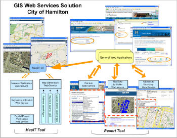
GIS Web services at the City of Hamilton. (Click for larger image)

The MapIT tool consists of a user interface (MapIT-UI) and four GIS Web services. The MapIT-UI is a gateway receiving calls from general Web applications and then sending parameters to, or receiving returns from, the Web services. The MapIT-UI displays a map which includes some user interaction capabilities such as zoom in, zoom out, pan, turn air photo on/off, and a user-friendly map print function. The four Web services include the following:
  1. Address Verification: Captures predefined parameters of street number, name, direction, suffix and community; performs some fuzzy logic validation with the parameters (e.g. alias name, also known as, street number +10 or +100); then returns a unique identifier Address_ID to MapIT-UI.
  2. Capital Project Verification: Captures parameters of feature class and key field, and returns a unique identifier Project_ID to MapIT-UI.
  3. Address Parsing and Keyword Verification: Captures a string from user inputs and parses it into either full street addresses (including street number and name) or non-addressable places (geographic entities such as parks, streets, rivers and lakes).
  4. Map Generation: Based on search type (address search, capital project search, key word search) and the unique identifiers that are passed from the MapIT-UI, this service generates a map that returns to MapIT-UI for display.
Currently there are three Web services for the Report tool. Unlike the MapIT tools, there is no user interface. Any Web application can directly call these Web services and display the geographically related demographic information or attribute information for specific features.
  1. Census Report: Captures boundary type (ward, planning unit, urban or rural) and boundary ID, and displays census data for the boundary area.
  2. Get Data by Buffer: Based on a user's defined distance, it generates a buffer against any known feature, and returns a list of data such as hotels, schools, parks and other facilities within the buffer. The format of the returned data is a .Net ADO dataset that can be easily displayed as a record. Even though it is a report service, there is still an option to return a map if it is needed.
  3. Address to Boundary: It returns boundary information in which the address is situated.
The GIS Web services solution brings GIS functionality to the city's general Web applications more quickly and easily than ever before and at no cost! This solution generates about 2,000 maps daily without staff intervention. The city's general Web applications can now offer better services to the citizens and to the general public by using the GIS Web services. Still more, based on the solutions, a new FindIt search tool was created when the MapHamilton site was made-over. By calling the Web services of Address Parsing and Keyword Verification service and Map Generation service, the FindIt search tool will return a list of matches according to any user entered address or place of interest in the City of Hamilton.

Share

Sharing is Caring


Geospatial Newsletters

Keep up to date with the latest geospatial trends!

Sign up

Search DM

Get Directions Magazine delivered to you
Please enter a valid email address
Please let us know that you're not a robot by using reCAPTCHA.
Sorry, there was a problem submitting your sign up request. Please try again or email editors@directionsmag.com

Thank You! We'll email you to verify your address.

In order to complete the subscription process, simply check your inbox and click on the link in the email we have just sent you. If it is not there, please check your junk mail folder.

Thank you!

It looks like you're already subscribed.

If you still experience difficulties subscribing to our newsletters, please contact us at editors@directionsmag.com