Software as a Service. High resolution images.
Geospatial technology. Future successful geospatial applications may
depend on one or more of these, or other trends. But there’s already
one
player out ahead of the rest: Go iLawn.
Directions Magazine interviewed Grant Gibson of GIS Dynamics
about the service.
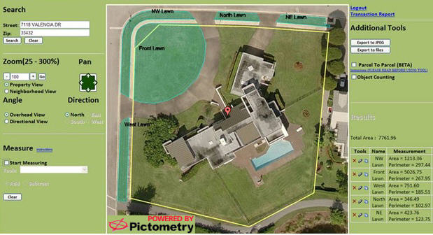
Directions Magazine (DM): What is Go iLawn and what types of companies are the target users?
Grant Gibson (GG): Go iLawn is an online subscription service designed to eliminate on site quoting for lawn and landscape companies. Go iLawn allows a professional to survey a property via a Software as a Service (SaaS) application. The service gives users a powerful blend of our property information combined with oblique imagery and measuring capabilities powered by Pictometry.
Traditionally, in order to provide a potential customer a service quote, a professional must first drive to the property in order to complete a survey. Go iLawn is changing the way lawn and landscape professionals quote by eliminating the need for travel, thereby saving both time and money. Go iLawn provides users with an accurate method of measuring residential and commercial properties to quote services including, but not limited to, fertilization, aeration, landscaping and snow removal without leaving the office.
DM: What does the person putting together the quote need to know to use Go iLawn? Is this something office staff will use?
GG: As a SaaS application, Go iLawn does not require you to purchase or install software. Access to Go iLawn requires an Internet connection and username and password. In order to view a property, a user must enter an address (street address and ZIP Code). The software returns a Pictometry high resolution aerial oblique image of the property with clearly marked county parcel lines.
The Go iLawn software is designed for a variety of users including customer services representatives, sales personnel, management, and field staff. Features include the ability to zoom in/out, pan, measure and label measurements. Additional tools include object counting and a parcel to parcel tool where users can jump from one property to the next without entering a new address. Users can export out their measurements in Excel or text format as well as an image of the property.
DM: Do you use any "off the shelf" or "off the cloud" technology?
GG: GIS Dynamics has developed proprietary technology to make Go iLawn scalable and open architecture.
DM: You only cover certain counties in the U.S. What is the limiting factor? Image resolution? Oblique coverage? Something else?
GG: While coverage for Go iLawn currently depends on the availability of county parcel data and corresponding county imagery, GIS Dynamics is continuously expanding its data set coverage while Pictometry does the same with its extensive nation-wide image library.
DM: Can you share how a typical customer takes advantage of the service? Have any documented significant returns on investment?
GG: By eliminating the need to conduct a physical survey of a property, each survey is completed in minutes from a computer, thereby saving both gas and time. Customers are currently utilizing the service for quoting and direct marketing.
Customers of the Go iLawn service have reported reductions in the time it takes to quote a property and reported the online service to be more accurate than traditional field measuring methods such as the measuring wheel. Eliminating travel time is reducing gas consumption and assisting companies in going green.
Any size company can take advantage of the Go iLawn service. With a tiered pricing structure, this powerful service is an economical approach for companies that would like to reduce costs and increase return on investment.
DM: What's planned for future releases?
GG: GIS Dynamics has received requests to expand the Go iLawn service outside of the United States. The future implementation of international coverage will be dependent upon availability of data sets.
 |
From Our Homepage
Saying Farewell to an Amazing Journey
Communicating with Maps
Is There a GIS Career Ladder?
What does it mean to be geospatially smart? Series
Ways Real Estate and Property Developers Utilize Melissa GeoData for Data-Driven Decisions
Unlocking Value From Daily Satellite Imagery and Insights
Maximizing the Value of Your Address Data with Geo Addressing
How Indoor Mapping Enhances the Security of Smart Buildings
Look Ahead: AI, Location Intelligence and Efficiency
Collaboration Takes on Sea Level Rise & Dynamic Technology Environments
Brownies for Brownfields
Has Everything Been Mapped Already?
How Is Data Literacy Changing in an Artificial Intelligence Landscape
Portfolios for GIS Professionals: More Than Just Maps
How to Create a Distance Matrix in QGIS - A Step-by-Step Guide
7 Ideas for Bringing GIS into the K-12 Classroom
The Geography of Movement