 For
more than a decade the City of Grand Junction, Colorado has received national
acclaim for its thriving business. Among Western Colorado's urban
areas, Grand Junction is the largest, with a population exceeding 120,000.
Over a decade the local economy grew at three times the rate of the population
and was the 12th fastest growing metropolitan economy in the nation during
the 1990s. In 2002, Grand Junction was named fifth in a list of "Entrepreneurial
Hot Spots: The Best Places in America to Start and Grow a Company" and
the greater Grand Junction Metropolitan Area Economy was ranked 17th strongest
in the nation.
For
more than a decade the City of Grand Junction, Colorado has received national
acclaim for its thriving business. Among Western Colorado's urban
areas, Grand Junction is the largest, with a population exceeding 120,000.
Over a decade the local economy grew at three times the rate of the population
and was the 12th fastest growing metropolitan economy in the nation during
the 1990s. In 2002, Grand Junction was named fifth in a list of "Entrepreneurial
Hot Spots: The Best Places in America to Start and Grow a Company" and
the greater Grand Junction Metropolitan Area Economy was ranked 17th strongest
in the nation.
Among the factors contributing to the strength of Grand Junction's economy, was its ability to attract new industries and reap the benefits of rising income. As the economy has grown, so too have the number of commercial developments needed to support its population.
When Grand Junction began its geographic information systems (GIS) implementation in 1991, the city spanned approximately 14 square miles.By the scheduled completion in 1995, the city had nearly doubled in size growing to 25 square miles.Despite the large geographic expansion, Grand Junction's GIS Manager insisted that the city be completely surveyed to ensure the greatest accuracy. This due diligence would later prove to be invaluable for developers as the accuracy was guaranteed.
Today, Grand Junction's GIS (www.gjcity.org) embodies the city's economic growth and serves as a nexus of information for anyone interested in developing or settling within the city limits. Data once regarded as proprietary to a specific city department is now stored and accessible through the Internet facilitating more efficient workflow for the city and developers alike.
"Grand Junction's technology infrastructure was designed to facilitate increased information flow and contact between its local government and the public," says Scott List, GIS analyst for the city's Community Development Department.
The Developer Dance
This nexus has been especially helpful to developers. Developers
interested in working within Grand Junction must first submit a development
application. Prior to its Internet-based GIS, the development application
process was an unduly onerous task.It was not unusual for developers to
spend more than a year on a single application. By conventional development
standards, this was an excessive amount of time for the demands of a fast-growing
city.
The development application was a time-consuming process because developers
were required to consolidate disparate information from a variety of city
departments. For example, developers would first visit the City Planning
Department where a technician would identify the development site and its
surrounding area on a detailed map.With that information, the developer
would proceed to the County Assessor's Office for a manually produced list
of area residents and their addresses because of municipal mandates requiring
that residents be notified in advanced of any new construction. Following
the resident notification, the developer sought water and sewer information
from the Department of Public Works (DPW) in order to incorporate this
information into the development application.
When all the disparate information had been collected, organized and
assembled properly the developer would return to the Planning Department
with a completed application. Any application falling short of the
necessary data in compliance with city code risked rejection until the
deficiencies were corrected.
As previously mentioned the application process alone could take upwards of a year and every bit was required before a developer could actually break ground on new construction. In addition, the application process did not include the time consuming process of conducting mandatory public meetings, to obtain public comment on the proposed project, or contractor bidding.
As Grand Junction began to build its GIS system, the city took great caution to integrate the information most often requested by developers first. Currently, all the information from the various city departments required for a development application is available online using the GIS system.With the GIS system, the new development application lifecycle has been reduced to as little as three months.The software used in Grand Junction's geographic information technology configuration is based on a series of Autodesk products including Map, MapGuide, Civil Series, and VIZ.
A Symbiotic Relationship
In addition to streamlining the application time, the GIS system also
made follow-on construction requirements easier by developing a symbiotic
relationship between the city and business.In the process of constructing
new developments, information that becomes available along the way is shared
or updated via the GIS. For example, once the application is approved,
a survey crew is dispatched within the city to gather field data on the
existing topology prior to construction.Civil engineers use this information
to design new streets and intersections (See Figure 1.)
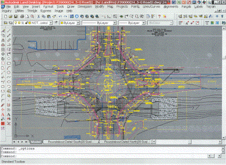
Figure 1. This is the roundabout at 241/2 Rd.and G Rd.Grand
Junction is using Civil
Series to design the roundabout. The city has created tabs
for each of the
sheets that make up the construction drawings so all of the plan
sheets are
in one drawing. This also makes it easier to plot the sheets
since a GIS
operator can highlight the tabs that are needed for printing and
send them
all to the plotter.
If a public meeting is needed to finalize construction plans, area photos are manipulated in conjunction with the existing civil engineering data to create photo realistic renderings of proposed projects areas.These photo-realistic renderings place the complex workings of development plans into a visual format that the average citizen can understand (See Figure 2).
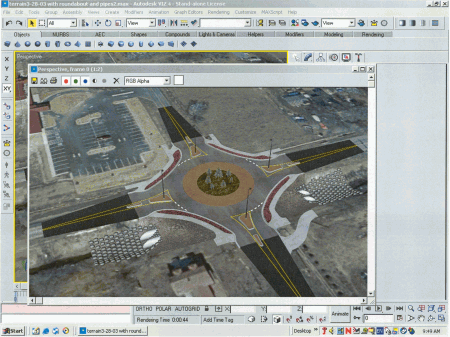
Figure 2.This is a rendering of the same roundabout.
Grand Junction is using 3D
Studio Vis to import the design that was prepared in Civil Series.
The city
has created this rendering for a public meeting so that constituents
can
view how the intersection will look upon completion.
Based on public hearings, final design changes can be easily made.Then final design contracting bids can be submitted based on complete, approved and accurate information about the development design.
The city is also able to provide staking data to the winning contractors' survey crew.Contractors import the points directly from the civil package and bring them into their field instruments.The contractor generates the final "as built" information and provides this to the city. The city in turn imports the data into the GIS and updates the systems layers and maps.
Once the GIS system is updated, SDF files (text files containing data
arranged in a standard format - every line of the file contains data for
one record and each field of the record is assigned to a certain position
within the line) are generated and loaded into the internet-based mapping
system (See Figure 3).Subsequently, information about the new construction
project becomes available online for access by city employees, citizens,
developers and consultants over the Internet.

Figure 3. City District Map (click for larger image)
Grand Junction is also able to proactively disseminate information about land that is ready for new opportunities to developers.To an interested developer, the availability of this critical information makes Grand Junction an even more attractive location for new projects. Developers are able to use the GIS system to conduct more efficient, cost-effective inquiries about development opportunities.
Likewise the Planning Department uses the same information to prepare site plan overviews for decision makers such as the City Council.These plans show officials where the site is located, the surrounding area, applicable zoning mandates and the city's previously established growth plans.
The impetus for developing the GIS systems in the Grand Junction - information sharing, cost savings and efficiency - has yielded benefits that few could claim to have foreseen. The city's use has been limited in no way except for imagination and has allowed the government to not only serve its constituents better, but has also figured out how to foster a relationship with the public that benefits both.