Technology Advancements
How did this demand come about? For starters, several technologies
have emerged that build on the concept of workflow integration.Recently,
development technologies such as .NET and COM have allowed us to build
customizable systems.In the past, systems were delivered based on technology
such as C and C++, which made it very difficult for users to customize
specific portions of their workflow based on their needs.With .NET and
COM, programmers can now use entry-level languages such as Visual Basic
to customize products that create working solutions.
Additionally, significant advancements have been made in the area of graphics card rendering and performance.New enhancements to graphics cards have become available to the mass market and improve the display of large image, feature and terrain datasets.Continuous zooming and roaming capabilities are now readily available, giving them more control over project workflow management.
Innovations in photogrammetric automation and the advent of all-digital workflows that eliminate film processing and scanning have further strengthened workflow integration.The intricate steps involved in automatic point measurement, automatic terrain extraction and simultaneous ortho-color balancing and mosaicking are being simplified.Some products incorporate automated routines that help customers run these functions faster.They also have built-in quality control and reporting tools to ensure accurate outputs.With these automated routines, users at all levels- from novice to expert- can perform photogrammetric steps quickly and accurately.These routines, coupled with the advent of digital workflows make project completion faster and easier than ever before.As digital sensors become more commonly used in the workplace, the industry is seeing processing software integrate smoothly with sensors and other imaging software technology.
Bridging the Gap Between Industries
The GIS and CAD worlds are clearly coming closer together and sharing
data.The once-significant gap between photogrammetry and desktop mapping
is noticeable smaller.Companies that cater to different industries such
as high-end photogrammetry and desktop mapping exemplify this trend.They
are creating products that merge technologies from different industries
and achieve data interoperability.For example, LPS software caters to
both photogrammetry and image processing professionals.A collection of
seamlessly-integrated software tools, LPS is scalable and is a process-driven
workflow that is customizable to complete a broad array of geospatial projects.
Other new products such as Image Analysis and Stereo Analyst for ArcGIS
can handle image processing and stereo feature collection workflows directly
within ESRI's ArcGIS environment.Such products empower GIS professionals
to perform processes they traditionally outsourced and enable different
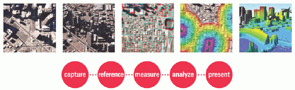
systems to share information.The emergence of products that service all
the links within the Geospatial Imaging Chain of creating, referencing,
measuring, analyzing and presenting geospatial information is significantly
bridging the gap between industries and simplifying workflows.
Streamlining Workflows
Many mapping projects require the use of different processes.Each
process has a different workflow associated with it and oftentimes the
workflows are not neatly integrated.A variety of technologies may be needed
to complete one job, which means using different products, data formats
and systems.How can a user overcome these challenges? By using systems
capable of data interoperability, spreading the workload among different
technology specialists internally or externally and using scalable and
customizable solutions.
In the average workplace, a knowledgebase of different technologies is generally maintained by one or two individuals within a company.As a result, resources working on a project must cleanly work and communicate to meet project deadlines.They must often use multiple software solutions that need to be pieced together in order to complete a project.Productivity is hindered, as organizations find themselves in a juggling act trying to figure out how to share data among the different software.Data interoperability is a necessity in all project workflows that employ more than one hardware or software solution.Additionally, lack of time and manpower cause data quality to be compromised.To streamline production, workflows must be integrated and data interoperability must be achieved between systems in order to accomplish the highest attainable production level while maintaining high accuracy.
Emerging products like those previously mentioned are integrating workflows and attaining data interoperability.Users can complete various tasks within one project faster and more accurately from start to finish.They can do this by sharing project workloads with different specialists within the office or outsourcing specific parts of a project to another company.By sharing responsibilities and/or outsourcing, users realize significant time and cost savings and the accuracy of a project is not compromised.
A key way to achieve workflow integration is to use a scalable and customizable product.No two production shops complete projects in the same way - all do them differently, using a variety of technologies such as photogrammetry, remote sensing, GIS, CAD and data visualization.Mapping professionals need products flexible enough to be scaled to accommodate a variety of workflows, but specific enough so that details can be exposed and modified to meet certain production mapping needs.These products should be easy to use, modified to meet different project needs and able to be used by various workers within an organization.
An example of the importance of workflow integration that applies to related geospatial industries is updating a citywide GIS.Traditionally, the various mapping jobs such as image acquisition, scanning, ortho-mosaicking and data collection have to be outsourced to various subcontractors.This is not a smooth workflow, as it means a client must wait on its sub-contractors to deliver a final product.It is necessary to find companies that are proficient at providing clients with process-driven workflows that deliver quality end results in a timely manner.With such offerings available, one company can now put together and solely manage a team of sub-contractors that can share data among different systems.The company also has the option to use various groups within one organization to complete the project. As both options allow the project to be managed by one company, the workflow is smooth, the data is integratable and the project can be completed faster without compromising overall quality.
The Future of Workflows
Further advancements towards workflow integration are still emerging.
The Internet will play an even bigger role in projects.It will be used
to manage large production projects more efficiently.Field crews will
be able to use sensors in the field to directly update GIS and CAD databases
and provide "live data updates." This will be done by systems that encompass
different technologies under one umbrella.These technologies will include
hardware, software, IT and live feature updating technologies.These are
exciting times for technology and it will be interesting to see new advancements
emerge and make product workflows easier than ever before.