Areva Resources Southern Africa pilots standard
technology platform
for managing and optimizing the use of its exploration information
assets in South Africa
When France's Areva, the world leader in technology solutions for nuclear power generation, acquired UraMin in mid-2007, that Canadian company was a junior success story. UraMin had picked up some low-grade concessions in Namibia near the huge Rossing mine when the uranium price was still relatively low, and proceeded to build its African portfolio. A rising uranium price made those acquisitions increasingly valuable and attractive to Areva, which was looking to diversify its resource base and secure long-term uranium supplies.
Renamed Areva Resources Southern Africa, the new subsidiary is expected to provide Areva with 7,000 tons of uranium per year by 2012. Starting later this year, production will come from three main deposits: Trekkopje in Namibia, Bakouma in the Central African Republic and Ryst Kuil in South Africa.
Today, Areva South Africa has an impressive portfolio of exploration projects throughout the continent that are benefitting from Areva's rare combination of expertise in uranium deposits and African exploration. But while project diversity is a blessing in exploration, it can also create data management challenges. In 2007, the company recognized it needed a better way to handle and share its exploration data to improve productivity and ensure project managers had access to the best available information.
Typical of many global mining companies, Areva's exploration geoscientists used several different software packages with no efficient way to integrate or share their knowledge and information. Meanwhile, the company's data managers were getting bogged down with incoming data that - with the right tools and some training - could be managed by the geoscientists in the field. And visual presentations to the company's decision makers were not as clear and comprehensible as they could have been.
Ariva partnered with Geosoft to take a more strategic approach to Exploration Information Management that would establish a complete technology solution and new standards for managing and effectively using all its exploration data assets in South Africa.
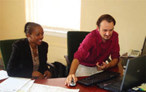
Olivier Masset, manager of Resources and GIS, and Nozuko Mani, GIS manager with Areva South Africa, led the needs assessment and business strategy for the exploration technology initiative. "We were spending a huge amount of time in data handling, manipulation and QC and we wanted a streamlined system with tools to empower data creators with self-managing their own data tasks," said Mani.
Given the diversity of software packages being used in the field and different offices, and the fact that there were a variety of data repositories, integration was also crucial. "At the end of it, we wanted a simplified view of the different datasets for our managers, and a common way to access data for our geologists working on projects," said Masset.
The anchor for Areva's Exploration Information Management solution is Geosoft's DAP server technology, which has allowed Areva's geoscientists access to data on demand from a single interface instead of having to tap into separate repositories for information. Integration with their Datamine MineTrust, Maxwell Datashed and LeaseControl systems expanded the breadth of data available to explorationists throughout the organization.
"Our DAP server is enabling us to build a library of maps and information for each project that we can share not only with geologists within our group, but with all exploration groups within our company," said Masset.
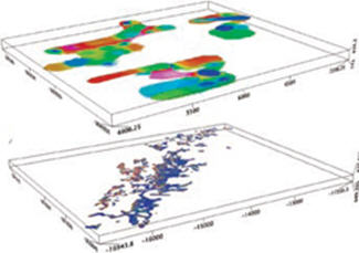
Areva South Africa has also standardized on common tools for its exploration projects: Geosoft's Oasis Montaj for advanced mapping and data processing of geophysics, geology and geochemistry; Target and Target for ArcGIS to create sections and 3-D models for subsurface (drillhole) data within its ArcGIS environment.
The tight integration between Geosoft exploration software and ESRI's ArcGIS has been critical; it has enabled Areva geologists to access, explore and work with their data directly within their ArcGIS or Geosoft environment, depending on the project on which they are working. Exchange of maps and data between the two environments is also fast and efficient with ArcGIS built into the Geosoft mapping platform.
Together, these tools have provided Areva Resources' multi-disciplinary exploration team in South Africa with a suite of spatial analysis tools that improve workflow by increasing efficiency, making decision making easier and supporting better communication between project team members and management. The improved productivity that comes from managing and sharing exploration information efficiently is a key business benefit.
"Our Geosoft and GIS software helped us to map everything out and manage our projects more effectively," said Masset. "We can combine and consider not only the geology, but all the relevant project information. That accelerates our decision making on - for instance - where to focus our exploration or whether to start drilling or resample."
According to Masset, before Areva Resources introduced the Geosoft software to its field offices, data would be sent to the head office in Johannesburg, where it would be made into sections and field maps before being sent back to the field. Using common exploration tools, the geoscientists can now complete these tasks in the field, saving time at head office and allowing project managers to make immediate decisions about where to explore next.
Masset is particularly enthusiastic about the ability to integrate data from the field into the exploration model, continuously providing his team with added information and fresh perspectives on the mineral potential of a particular project.
Data mobility is also an important advantage. With this solution, managers and geologists can move from region to region and still have easy access to data housed in the DAP server in Johannesburg. "Access to information and the ability to share information in real-time is important to us," said Masset. "The ability to do this on a global basis, where someone from southern Africa can go to Canada and find the same data, is a competitive advantage that enables us to be more flexible and quicker in developing our projects."
Compatibility with other programs, not only within the Geosoft suite but from other software providers (e.g. AutoCAD), is another feature that makes the job easier for Mani. "As a person managing the company's GIS database which stores critical information about 3D maps, borehole plans and sections for analysis, I would say Geosoft has enormous capabilities, including bringing in data from different formats used in the mining and exploration industry."
"We're encouraged with our progress," said Mani. "As more geologists and managers are trained on the new tools, they are gaining confidence in the quality of the data and their ability to extract information from their data. There's no doubt this will impact our ability to develop our projects and make meaningful decisions."
As a result, Areva has made its new Southern African subsidiary a test pilot for establishing a common platform for exploration including protocols, best practices and software tools that are standard across the organization. If proven successful, the common exploration platform Areva Southern Africa is striving to create could become a model not only for its parent company, but for the mining sector as well.
The core platform benefits of the Geosoft DAP Server solution include the ability to perform complex spatial and/or metadata searches and the ability to automatically window, reproject and resample data.
Integration between Areva's DAP Server and other in-house exploration data repositories streamlined the data searching/retrieval process and reduced reliance on specific software client applications. Areva published the data stored in its Maxwell Datashed and LeaseControl systems via its DAP server.
As a result, any user within the Areva organization can now browse, preview and retrieve any required drillhole or tenement information (including all associated metadata) regardless of what client applications they have installed.
Hunsaker Inc: Exploring the data-rich Nevada goldfields
As a well-established consulting geologist working in the middle of the Nevada goldfields, Buster Hunsaker has adopted software and GIS as a critical part of his exploration tool kit - both in the field and in the office.
Being faster and more efficient in using technology for geological insight and project management has given him an edge in what can be a competitive business, especially during cyclical downturns in the mining industry like the one we are experiencing today. More importantly, it's enabled him to produce better results for his customers.
"Our expertise in GIS has opened a lot of doors for us," said Hunsaker, who specializes in early stage gold exploration projects. "As a consultant, bringing both our experience and technology to bear on projects is a tremendous advantage. We see a real gap in the application of technology to exploration. There are not as many senior people applying it as there should be."
The Carlin gold belt in north-central Nevada is one of the richest in the world. Hunsaker estimates that about 8% of global gold production comes from deposits within 100 km of his headquarters in Elko, Nevada. Because the state has been so intensively mined and explored over the years, there is a rich store of available data, including a comprehensive subsurface database.
That's where the application of digital technology comes in handy. Without the tools to process and make sense of it, all those data would be mindboggling at best and virtually useless at worst.
Using ESRI's ArcView to visualize geographic data in combination with Geosoft's Target for ArcGIS to manage drill projects, Hunsaker has been able to integrate volumes of old and new data, both public and private, to highlight areas with mineral potential, work within different scales, and generate 3-D renderings of the information.
"There are a lot of new geological concepts coming out in Nevada," he said. "We can take the new geologic maps and apply existing data to them and it gives us new ways to interpret the existing data."
Though Hunsaker has been using GIS for years, many mining companies are just beginning to see the value of integrating geological, geochemical and geophysical data from government geological surveys - which are increasingly publishing data in ESRI formats - with their own exploration data, as part of their workflow. The most obvious advantages are efficiencies in project and data management, time savings, increased productivity and better decision making.
The introduction of extensions for GIS systems such as Geosoft's Target for ArcGIS has made the suite of spatial analysis tools even more powerful by providing the ability to visualize subsurface geological data within a GIS environment. "We wouldn't consider doing something without the third dimension, if we have drill data available," said Hunsaker, "and Target provides the ability to handle that third dimension quickly and easily. That's both the geophysics as well as the drillhole data."
"Having the 3D perspective also means we're quite comfortable bringing in a lot of data because we're confident we can handle it and it won't overwhelm us," said Hunsaker. Hunsaker's adoption of GIS for mineral exploration began 12 years ago when he was looking for an efficient way to track federal mining claims. A colleague directed him to ArcView and he has never looked back. "ArcView's ability to handle large amounts of data led us to expand from land title data to all kinds of geologic data," he said.
As Hunsaker's experience with GIS grew, he was able to take the mostly raster data available in Nevada and convert them into GIS format. That gave him another edge over the competition. "From a business viewpoint it has become a good income stream for us."
Another unique aspect of Hunsaker's approach to exploration has been his use of ESRI's ArcPad, a software program that allows data capture in the field on ultra-rugged field computers or hand-held devices. The software is commonly used in urban areas where there is easy access to cell phone networks, but is just beginning to penetrate the mineral exploration industry.
Using ArcPad has allowed Hunsaker to generate data in GIS format while he is in the field, resulting in an instant compatibility between field and office that would not be possible were he still using a notebook to scribble observations about outcrops and other geological information.
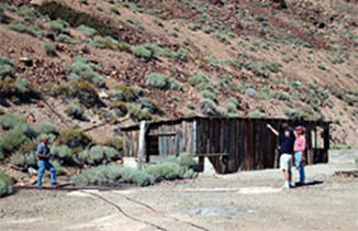
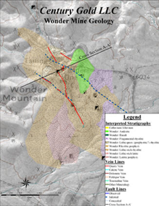
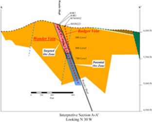
In the historic gold mining district of Wonder, Nevada, for instance, Hunsaker used ESRI's ArcMap to convert 34 years of data generated by his client and a century of archival data into a standard GIS coordinate system. He then took the subsurface data - including results from more than 100 boreholes - and applied Geosoft's Target for ArcGIS to generate cross sections.
He added even more value to the historic data by using ArcPad to
complete additional surface mapping in the field, creating another
layer of digital information that could be used to explore the
district. "The ArcMap model and the Geosoft extension allowed me to
generate sections that have the latest mapping from ArcPad windowed in
the plan portion, straight out of the field," he said.
As important as it is today, adapting technology to exploration will be even more essential in the future.
"We are generating massive amounts of data, all of it digital and most in GIS format. You need technology to effectively explore all this new data and fit it in to your projects," said Hunsaker. "The new technology that's coming on stream, like Geosoft DAP and Dapple, is phenomenal. You can take an AirCard even in an area where you have limited coverage, and you can take a cell connection with your tablet computer and access these data sets."
"Don't even think about the old tools," he advises other explorationists. "Think about the new tools that are coming on board. You need to become really efficient with data."
When France's Areva, the world leader in technology solutions for nuclear power generation, acquired UraMin in mid-2007, that Canadian company was a junior success story. UraMin had picked up some low-grade concessions in Namibia near the huge Rossing mine when the uranium price was still relatively low, and proceeded to build its African portfolio. A rising uranium price made those acquisitions increasingly valuable and attractive to Areva, which was looking to diversify its resource base and secure long-term uranium supplies.
Renamed Areva Resources Southern Africa, the new subsidiary is expected to provide Areva with 7,000 tons of uranium per year by 2012. Starting later this year, production will come from three main deposits: Trekkopje in Namibia, Bakouma in the Central African Republic and Ryst Kuil in South Africa.
Today, Areva South Africa has an impressive portfolio of exploration projects throughout the continent that are benefitting from Areva's rare combination of expertise in uranium deposits and African exploration. But while project diversity is a blessing in exploration, it can also create data management challenges. In 2007, the company recognized it needed a better way to handle and share its exploration data to improve productivity and ensure project managers had access to the best available information.
Typical of many global mining companies, Areva's exploration geoscientists used several different software packages with no efficient way to integrate or share their knowledge and information. Meanwhile, the company's data managers were getting bogged down with incoming data that - with the right tools and some training - could be managed by the geoscientists in the field. And visual presentations to the company's decision makers were not as clear and comprehensible as they could have been.
Ariva partnered with Geosoft to take a more strategic approach to Exploration Information Management that would establish a complete technology solution and new standards for managing and effectively using all its exploration data assets in South Africa.
Olivier Masset, manager of Resources and GIS, and Nozuko Mani, GIS manager with Areva South Africa, led the needs assessment and business strategy for the exploration technology initiative. "We were spending a huge amount of time in data handling, manipulation and QC and we wanted a streamlined system with tools to empower data creators with self-managing their own data tasks," said Mani.
 |
Given the diversity of software packages being used in the field and different offices, and the fact that there were a variety of data repositories, integration was also crucial. "At the end of it, we wanted a simplified view of the different datasets for our managers, and a common way to access data for our geologists working on projects," said Masset.
The anchor for Areva's Exploration Information Management solution is Geosoft's DAP server technology, which has allowed Areva's geoscientists access to data on demand from a single interface instead of having to tap into separate repositories for information. Integration with their Datamine MineTrust, Maxwell Datashed and LeaseControl systems expanded the breadth of data available to explorationists throughout the organization.
"Our DAP server is enabling us to build a library of maps and information for each project that we can share not only with geologists within our group, but with all exploration groups within our company," said Masset.
Areva South Africa has also standardized on common tools for its exploration projects: Geosoft's Oasis Montaj for advanced mapping and data processing of geophysics, geology and geochemistry; Target and Target for ArcGIS to create sections and 3-D models for subsurface (drillhole) data within its ArcGIS environment.
The tight integration between Geosoft exploration software and ESRI's ArcGIS has been critical; it has enabled Areva geologists to access, explore and work with their data directly within their ArcGIS or Geosoft environment, depending on the project on which they are working. Exchange of maps and data between the two environments is also fast and efficient with ArcGIS built into the Geosoft mapping platform.
Together, these tools have provided Areva Resources' multi-disciplinary exploration team in South Africa with a suite of spatial analysis tools that improve workflow by increasing efficiency, making decision making easier and supporting better communication between project team members and management. The improved productivity that comes from managing and sharing exploration information efficiently is a key business benefit.
"Our Geosoft and GIS software helped us to map everything out and manage our projects more effectively," said Masset. "We can combine and consider not only the geology, but all the relevant project information. That accelerates our decision making on - for instance - where to focus our exploration or whether to start drilling or resample."
 |
According to Masset, before Areva Resources introduced the Geosoft software to its field offices, data would be sent to the head office in Johannesburg, where it would be made into sections and field maps before being sent back to the field. Using common exploration tools, the geoscientists can now complete these tasks in the field, saving time at head office and allowing project managers to make immediate decisions about where to explore next.
Masset is particularly enthusiastic about the ability to integrate data from the field into the exploration model, continuously providing his team with added information and fresh perspectives on the mineral potential of a particular project.
Data mobility is also an important advantage. With this solution, managers and geologists can move from region to region and still have easy access to data housed in the DAP server in Johannesburg. "Access to information and the ability to share information in real-time is important to us," said Masset. "The ability to do this on a global basis, where someone from southern Africa can go to Canada and find the same data, is a competitive advantage that enables us to be more flexible and quicker in developing our projects."
Compatibility with other programs, not only within the Geosoft suite but from other software providers (e.g. AutoCAD), is another feature that makes the job easier for Mani. "As a person managing the company's GIS database which stores critical information about 3D maps, borehole plans and sections for analysis, I would say Geosoft has enormous capabilities, including bringing in data from different formats used in the mining and exploration industry."
"We're encouraged with our progress," said Mani. "As more geologists and managers are trained on the new tools, they are gaining confidence in the quality of the data and their ability to extract information from their data. There's no doubt this will impact our ability to develop our projects and make meaningful decisions."
As a result, Areva has made its new Southern African subsidiary a test pilot for establishing a common platform for exploration including protocols, best practices and software tools that are standard across the organization. If proven successful, the common exploration platform Areva Southern Africa is striving to create could become a model not only for its parent company, but for the mining sector as well.
The core platform benefits of the Geosoft DAP Server solution include the ability to perform complex spatial and/or metadata searches and the ability to automatically window, reproject and resample data.
Integration between Areva's DAP Server and other in-house exploration data repositories streamlined the data searching/retrieval process and reduced reliance on specific software client applications. Areva published the data stored in its Maxwell Datashed and LeaseControl systems via its DAP server.
As a result, any user within the Areva organization can now browse, preview and retrieve any required drillhole or tenement information (including all associated metadata) regardless of what client applications they have installed.
Hunsaker Inc: Exploring the data-rich Nevada goldfields
As a well-established consulting geologist working in the middle of the Nevada goldfields, Buster Hunsaker has adopted software and GIS as a critical part of his exploration tool kit - both in the field and in the office.
 |
Being faster and more efficient in using technology for geological insight and project management has given him an edge in what can be a competitive business, especially during cyclical downturns in the mining industry like the one we are experiencing today. More importantly, it's enabled him to produce better results for his customers.
"Our expertise in GIS has opened a lot of doors for us," said Hunsaker, who specializes in early stage gold exploration projects. "As a consultant, bringing both our experience and technology to bear on projects is a tremendous advantage. We see a real gap in the application of technology to exploration. There are not as many senior people applying it as there should be."
The Carlin gold belt in north-central Nevada is one of the richest in the world. Hunsaker estimates that about 8% of global gold production comes from deposits within 100 km of his headquarters in Elko, Nevada. Because the state has been so intensively mined and explored over the years, there is a rich store of available data, including a comprehensive subsurface database.
That's where the application of digital technology comes in handy. Without the tools to process and make sense of it, all those data would be mindboggling at best and virtually useless at worst.
Using ESRI's ArcView to visualize geographic data in combination with Geosoft's Target for ArcGIS to manage drill projects, Hunsaker has been able to integrate volumes of old and new data, both public and private, to highlight areas with mineral potential, work within different scales, and generate 3-D renderings of the information.
"There are a lot of new geological concepts coming out in Nevada," he said. "We can take the new geologic maps and apply existing data to them and it gives us new ways to interpret the existing data."
Though Hunsaker has been using GIS for years, many mining companies are just beginning to see the value of integrating geological, geochemical and geophysical data from government geological surveys - which are increasingly publishing data in ESRI formats - with their own exploration data, as part of their workflow. The most obvious advantages are efficiencies in project and data management, time savings, increased productivity and better decision making.
The introduction of extensions for GIS systems such as Geosoft's Target for ArcGIS has made the suite of spatial analysis tools even more powerful by providing the ability to visualize subsurface geological data within a GIS environment. "We wouldn't consider doing something without the third dimension, if we have drill data available," said Hunsaker, "and Target provides the ability to handle that third dimension quickly and easily. That's both the geophysics as well as the drillhole data."
"Having the 3D perspective also means we're quite comfortable bringing in a lot of data because we're confident we can handle it and it won't overwhelm us," said Hunsaker. Hunsaker's adoption of GIS for mineral exploration began 12 years ago when he was looking for an efficient way to track federal mining claims. A colleague directed him to ArcView and he has never looked back. "ArcView's ability to handle large amounts of data led us to expand from land title data to all kinds of geologic data," he said.
As Hunsaker's experience with GIS grew, he was able to take the mostly raster data available in Nevada and convert them into GIS format. That gave him another edge over the competition. "From a business viewpoint it has become a good income stream for us."
Another unique aspect of Hunsaker's approach to exploration has been his use of ESRI's ArcPad, a software program that allows data capture in the field on ultra-rugged field computers or hand-held devices. The software is commonly used in urban areas where there is easy access to cell phone networks, but is just beginning to penetrate the mineral exploration industry.
Using ArcPad has allowed Hunsaker to generate data in GIS format while he is in the field, resulting in an instant compatibility between field and office that would not be possible were he still using a notebook to scribble observations about outcrops and other geological information.
In the historic gold mining district of Wonder, Nevada, for instance, Hunsaker used ESRI's ArcMap to convert 34 years of data generated by his client and a century of archival data into a standard GIS coordinate system. He then took the subsurface data - including results from more than 100 boreholes - and applied Geosoft's Target for ArcGIS to generate cross sections.
 |
 |
As important as it is today, adapting technology to exploration will be even more essential in the future.
"We are generating massive amounts of data, all of it digital and most in GIS format. You need technology to effectively explore all this new data and fit it in to your projects," said Hunsaker. "The new technology that's coming on stream, like Geosoft DAP and Dapple, is phenomenal. You can take an AirCard even in an area where you have limited coverage, and you can take a cell connection with your tablet computer and access these data sets."
"Don't even think about the old tools," he advises other explorationists. "Think about the new tools that are coming on board. You need to become really efficient with data."
From Our Homepage
Saying Farewell to an Amazing Journey
Communicating with Maps
Is There a GIS Career Ladder?
What does it mean to be geospatially smart? Series
Ways Real Estate and Property Developers Utilize Melissa GeoData for Data-Driven Decisions
Unlocking Value From Daily Satellite Imagery and Insights
Maximizing the Value of Your Address Data with Geo Addressing
How Indoor Mapping Enhances the Security of Smart Buildings
Look Ahead: AI, Location Intelligence and Efficiency
Collaboration Takes on Sea Level Rise & Dynamic Technology Environments
Brownies for Brownfields
Has Everything Been Mapped Already?
How Is Data Literacy Changing in an Artificial Intelligence Landscape
Portfolios for GIS Professionals: More Than Just Maps
How to Create a Distance Matrix in QGIS - A Step-by-Step Guide
7 Ideas for Bringing GIS into the K-12 Classroom
The Geography of Movement